Sold2018Vintage WWII News Map of the Russian Front, 1943Title/Content of Map: Newsmap. Date Printed: 27/09/1943 Cartographer: ANONYMOUS Publisher: ARMY INFORMATION BRANCH 1943-09-27 WASHINGTON, DC Size: Wall - 35"H. x 47"W "211th week of the war. 93rd weekSee Sold Price
Sold2018Vintage WWII Colliers War Map of Europe, 1942Title/Content of Map: Colliers War Map of Europe Date Printed: 1942 Cartographer: RAND MCNALLY & COMPANY Publisher: P. F. COLLIER & SON CORPORATION 1942 NEW YORK Size: Folio – 19.00 H x 25.75 W InchSee Sold Price
Sold201911 Vintage Assorted World War II Maps of Europe11 Vintage Assorted World War II Maps of Europe from the 1940's, used condition, wear, worn.See Sold Price
Sold2020Original WWII-Era Map of FranceOriginal WWII-Era Map of France - Offered Without Reserve - There is NO ESTIMATE on this item. - Vintage Original WWII Era Map of the Zones of France, Railroads Shown, Important Beaches and LocationsSee Sold Price
Sold2022LOT OF AMERICAN WWII MILITARY PROPAGANDA POSTERSA collection of six American WWII military propaganda posters Newsmap Armed Forces, 1943 - 1945. The posters contain information about the progress of the war, photographs and maps. World War II And ASee Sold Price
Sold2020Original WWII U.S. Army Silk Evasion MapsOriginal WWII U.S. Army Silk Evasion Maps - Offered Without Reserve - There is NO ESTIMATE on this item. - Vintage Original WWII U.S. Army Silk Evasion Maps for Aviators Depicting Central FranceSee Sold Price
Sold2019Six (6) Vintage Prints of MapsLot of Six (6) Vintage Prints of Maps. Images of central Europe, atlas of the world, British colonies in North America, France, and Europe. Size range from 20-3/4 x 26-3/4" W to 15-3/4" H x 13-5/8" W.See Sold Price
Sold2022Vintage Bastille Gay Parade Plastic Photo SlideLangres France, July 1945, WW2 - segregated army, 2X2 inchesSee Sold Price
Sold2021Newsmap US army WWII publication Armed service forceVintage folded poster distributed to the army during WWII , those were not widly distributed , used in officer quarter and service men facility .This poster report on the first week after D.Day June 1See Sold Price
Sold2023U.S. MILITARY WWII FIELD MAPS 1943-1944(5)170300 U.S. MILITARY WWII FIELD MAPS 1943-1944(5) U.S. military WWII field maps 1943-1944 to include one original Europe Road Map Series 1 first edition France with name of soldier Caldwell, two WWIISee Sold Price
Sold2022Daily News end of WWII newspapersDaily News August 15, 1945 and May 8, 1945 end of WWII in Europe and Japan newspapers (not known if complete)See Sold Price
Sold2023WWII U.S. MILITARY FIELD MAPS 1939-1945 - (4)170301 WWII U.S. MILITARY FIELD MAPS 1939-1945 - (4) WWII U.S. military field maps 1939- 1945 to include one East and West Omaha beach scanned "Bigot" Field maps, one France (12500) Isigny field map,See Sold Price
Sold2022WW2 'WESTERN FRONT' in 1940. Bird's eye view before invasion of France 1940 mapTITLE/CONTENT OF MAP: 'Daily Mail Air-View Map of the Western Front' DATE PRINTED: 1940 IMAGE SIZE: Approx 97.0 x 74.0cm, 38 x 29 inches (Large) TYPE: Vintage colour map; Scale 10 miles: 1 inch CONDITSee Sold Price
Sold2021Two WWII Illustrated Campaign Maps FramedOperations of First United States Army in Europe from June 6, 1944 to May 9, 1945, surrounded by division logos. Measures 20"H x 19.5"W framed, 17.75"H x 18"W unframed. First U.S. Army & Fifth USSR CaSee Sold Price
Sold2020WWII 78th Infantry Division Color Insignia Army War MapWWII 78th Infantry Division Color War Map. Titled: Lighting Strikes Twice. 1918-1945. 1918: St. Mihiel, Lorraine, Meuse-Argonne. 1945: Ardennes, Rhineland, Central-Europe. Prepared by the 303 EngineerSee Sold Price
Sold2015MUSSOLINI BENITO: (1883-1945) Italian Fascist DictatorMUSSOLINI BENITO: (1883-1945) Italian Fascist Dictator of World War II. Vintage signed 7.5 x 10.5 photograph of Il Duce seated in a head and shoulders pose. Signed, with a slightly hurried signature (See Sold Price
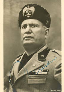
Sold2018MUSSOLINI BENITO: (1883-1945)MUSSOLINI BENITO: (1883-1945) Italian Fascist Dictator of World War II. Vintage signed postcard photograph, the image showing Il Duce in a half length pose, wearing his military fascist uniform. SigneSee Sold Price
Sold2023World War 2. Eastern Front. 16 April-7 May 1945. Final Russian Campaign 1959 mapTITLE/CONTENT OF MAP: 'The War in Eastern Europe - Final Russian Campaign in Central Europe - Operations, 16 April-7 May 1945' DATE PRINTED: 1959 IMAGE SIZE: Approx 25.0 x 33.5cm, 9.75 x 13 inches (LaSee Sold Price
Sold2022Now All Together Original Vintage Poster by C.C. Beall for WWII 7th War LoanThis poster from 1945 by Cecil Calvert (C.C.) Beall (1892-1967) and commissioned by the Official US Treasury was made for promoting the 7th War Loan, just days after the victory in Europe. Beall was cSee Sold Price
Sold2023Now All Together Original Vintage Poster by C.C. Beall for WWII 7th War Loan LargeThis poster from 1945 by Cecil Calvert (C.C.) Beall (1892-1967) and commissioned by the Official US Treasury was made for promoting the 7th War Loan, just days after the victory in Europe. Beall was cSee Sold Price
Sold2023Now All Together Original Vintage Poster by C.C. Beall for WWII 7th War LoanThis poster from 1945 by Cecil Calvert (C.C.) Beall (1892-1967) and commissioned by the Official US Treasury was made for promoting the 7th War Loan, just days after the victory in Europe. Beall was cSee Sold Price
Sold2023Now All Together Original Vintage Poster by C.C. Beall for WWII 7th War Loan LargeThis poster from 1945 by Cecil Calvert (C.C.) Beall (1892-1967) and commissioned by the Official US Treasury was made for promoting the 7th War Loan, just days after the victory in Europe. Beall was cSee Sold Price
Sold2018Chinkiang ZHENJIANG. China. WW2 ROYAL NAVY INTELLIGENCETITLE/CONTENT OF MAP: 'Fig. 58. Chinkiang' DATE PRINTED: 1945 IMAGE SIZE: Approx 7.5 x 9.0cm, 3 x 3.5 inches (Small) TYPE: Vintage Second World War naval intelligence colour map CONDITION: Fair: VersoSee Sold Price
Sold2022WWII 1945 87th Infantry Division Framed Battle Operations MapWWII 1945 87th Infantry Division Framed Battle Operations Map. Route of the Golden Acorn Division: France, Luxembourg, Belgium, Germany, and Czechoslovakia. Approximate size is 19 x 29 inches. NicelySee Sold Price
Jun 20The Ross Art GroupOriginal WWII Vintage Poster - A Careless Word A Needless Sinking by Anton Fischer 1943$350
Jun 20The Ross Art GroupNow All Together Original Vintage Poster by C.C. Beall for WWII 7th War Loan Large$500
Jun 20The Ross Art GroupOriginal Vintage Chocolat Menier Le Tour de Monde Poster by Jannot 1956 Chocolate Map$500
6 days LeftWorthington GalleriesAntique H/C Map EUROPE SOUS CHARLEMAGNE EN 814: EMPIRES D'OCCIDENT ET D'ORIENT$25
Jun 20The Ross Art GroupOriginal Air France Planisphere Brown Vintage Map by Lucien Boucher 1948$1,200
4 days LeftFive Star AuctionsA Vintage French LALIQUE Fish Head Figural Frosted & Crystal Bowl Centerpiece, Signed$800
1 day LeftJasper521775 d'Anville Map of Middle Ages Europe -- Germany, France, Italy, Spain, British Isles, In an$70
Jun 20The Ross Art GroupOriginal Vintage WWII Poster Back Your Infantry Buy Extra Bonds by Schlaikjer 1945$250
Jun 20The Ross Art GroupOriginal Vintage WWII George Washington Carver Victory Bond Poster by Kautz 1945$800
6 days LeftAnnzstiques Auction HouseVintage WWII Era U.S. Stainless Steel Mess Kit E.A. Co. Dated 1945$29
Jun 20The Ross Art GroupOriginal Vintage Air France World Route Map Vickers Viscount Poster 1956 Constellation$600
1 day LeftJasper521775-1780 North West Africa with Cape Verde and Canary Islands. By Bonne and Raynal$20