Sold2021Maps 1813-1904 Mixed Lot of 4. Ireland, Canada, AfricaLot of 4 Engraved and Lithographed Maps. Incl Wellington Channel (Canada) Belfast/Cork Town Plans, Parliamentry Map of Ireland and an Untitled Map of Africa. Examples by Bruce, Fullarton and BartholomSee Sold Price
Sold2022UK & Ireland 19th Cent. Lot of 6 Town & City PlansIncl Dublin, Plymouth, Portsmouth, Glasgow, Edinburgh, and Portrush/Mullaghmore/Galway/Londondenderry/Sligo. Steel Engraved and Lithograph Maps. Examples by Brockhaus, Fullarton/Swanston and BartholomSee Sold Price
Sold2022English town plans.- Braun (Georg) and Franz Hogenberg.NO RESERVE English town plans.- Braun (Georg) and Franz Hogenberg. Nordovicum Angliae Civitas, bird's-eye plan of Norwich, from 'Civitates Orbis Terrarum', engraving with original hand-colouring, platSee Sold Price
201716th Century Town Plans from Braun & HogenbergTitle: The City Maps of Europe. 16th Century Town Plans from Braun & Hogenberg Chicago. Rand McNally. 1991 Author(s): Goss, John First edition. Condition: Fine copy in fine dust jacket (in mylar). FolSee Sold Price
Sold2024MANCHESTER & SALFORD town plan by LAURENT. Large 102x95cm 1793 old antique mapTitle: MANCHESTER & SALFORD town plan by LAURENT. Large 102x95cm 1793 old antique mapDescription: A Topographical plan of Manchester and Salford with the adjacent parts; shewing also the different allSee Sold Price
Sold2020LEGO Collector Set #10184 Town Plan New and UnopenedLEGO Collector Set #10184 Town Plan New and Unopened: Incredible LEGO collector set. All of the LEGO sets in the auction are from a single home, high end collector of LEGO's. These are all unopened boSee Sold Price
Sold2018THE GREAT SALT LAKE (MORMON) CITY'. Town plan &TITLE/CONTENT OF MAP: 'The Great Salt Lake (Morman) City and Surrounding Country; Map of the Great Salt Lake and Adjacent Country in the Territory of Utah' DATE PRINTED: 1863 IMAGE SIZE: Approx 44.5 xSee Sold Price
Sold2022HAVANA. Vintage town plan. Railways & streetcar lines. Cuba. Caribbean 1923 mapTITLE/CONTENT OF MAP: 'Havana' DATE PRINTED: 1923 IMAGE SIZE: Approx 18.5 x 15.0cm, 7.25 x 6 inches (Medium); Please note that this is a folding map. TYPE: Vintage map CONDITION: Good; suitable for frSee Sold Price
Sold2022HAVANA. Vintage town plan. Railways & streetcar lines. Cuba. Caribbean 1927 mapTITLE/CONTENT OF MAP: 'Havana' DATE PRINTED: 1927 IMAGE SIZE: Approx 18.5 x 15.0cm, 7.25 x 6 inches (Medium); Please note that this is a folding map. TYPE: Vintage map CONDITION: Good; suitable for frSee Sold Price
Sold20191769 Gentleman's Magazine Colonial Town PlanThe October 1769 issue of Gentleman’s Magazine, printed at London. 48 pages, no plates. Includes articles on Plan for Settling New Colonies and on a new species of Penguins. Much else, Fine, magazinSee Sold Price
Sold2023HAVANA. Vintage town plan. Railways & streetcar lines. Cuba. Caribbean 1923 mapHavana' by Sifton, Praed & Co. Ltd, St. James's St. London S.W. (1923). Vintage map, 18.5 x 15.0cm, 7.25 x 6 inches; Please note that this is a folding map. Additional Information: CAPTION PRINTED BELSee Sold Price
Sold2022HAVANA. Vintage town plan. Railways & streetcar lines. Cuba. Caribbean 1935 mapTITLE/CONTENT OF MAP: 'Part of Havana' DATE PRINTED: 1935 IMAGE SIZE: Approx 18.5 x 15.5cm, 7.25 x 6.25 inches (Medium); Please note that this is a folding map. TYPE: Vintage map CONDITION: Good; suitSee Sold Price
Sold2018SDUK (Pub) 1830's Town Plan Map of Parma, Italy"Parma" Steel Engraved Map Published 1830's, London for "Maps by the Society for the Diffusion of Useful Knowledge" Paper Size: 16.5 x 13.5 inch (42 x 34cm) Good ConditionSee Sold Price
2022Original Hand-Colored Plan and View of Grodno in 1562.An historic view of Grodno, Belarus. An engraving from Braun & Hogenberg's Civitatus Orbis Terrarum, printed in Cologne, and acknowledged to be the most important book of town plans and views publisheSee Sold Price
Sold2017Antique French Map and Plan of Boston, MassachusettsTitle/Content of Map: Antique French Map and Plan of Boston, Massachusetts Date Printed: 1757 Cartographer: Bellin, Jacques Nicolas Size (in): 10 x 6 One of the earliest obtainable town plans of BostoSee Sold Price
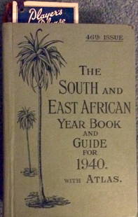
Sold2016Vintage 1940 Decorated HC South/East African Travel bkVintage 1940 Hardcover South & East African Travel Book. "The South and East African Year Book and Guide 1940, with Atlas, Town Plans, and Diagrams. By A. Gordon Brown. HARDCOVER. 1940 Sampson, Low, MSee Sold Price
Sold2022MAPS: John Speed (England, 1552-1629), threeMAPS: John Speed (England, 1552-1629), three hand-colored maps on paper: one a map of Suffolk with town plan of Ipswich, dated 1610 in block, described and divided into hundreds, inset plan of IpswichSee Sold Price
Sold2022English county maps.- Northern England.- Speed (John)NO RESERVE English county maps.- Northern England.- Speed (John) Anno Darbieshire described, county map, inset town plan of Derby and inset view of St Anne's well at Buxton, engraving, 385 x 510 mm (1See Sold Price
Sold2020Ivan Schwebel (Israeli/American, 1932-2011)Ivan Schwebel (Israeli/American 1932-2011). Etching on paper. The Matronita Passing Mamilla with the Jerusalam Town Plan. Unsigned. In wood frame. Includes three handwritten and typed letters from SchSee Sold Price
2017The Great Salt Lake (Mormon) CityDescription: The Great Salt Lake (Mormon) City. Town plan & environs maps. WELLER, 1863 Dimensions: Approx 44.5 x 31.5cm, 17.5 x 12.25 inches Please note that this lot has a confidential reserve. WhenSee Sold Price
Sold2020Antique Johnson and Ward "Holy Land" MapDESCRIPTION: map of the Holy Land, based upon the 12 tribes and contemporary (to mid-19th Century) borders. Insets of view of Damascus and town plan of Jerusalem. Shows towns, roads, rivers, lakes, moSee Sold Price
Sold2024Detailed Plan Of The City Of Ghent, c.1785Detailed plan of the City of Ghent, including fortifications, town plan, roads, farms, rivers, and a decorative compass rose. From Tindal's Continuation of Rapin's History. Genuine Antique MapSee Sold Price
Sold20231719 Mallet map of Dublin -- DublinTitle: 1719 Mallet map of Dublin -- Dublin Cartographer: A Mallet Year / Place: 1719, Frankfurt Map Dimension (in.): 5.9 X 3.9 in. This is a rather nice town plan of Dublin, showing the Leffer River,See Sold Price
4 days LeftScollard AuctionsPeriod Engraving of The Arms & Seals of Cities & Borough Towns by William Jackson circa 1714$90
2 days LeftJasper521732 Homann Map of Nurnberg -- Grundris der des Heil Rom. Reichs Freyen Stadt Nurnberg$190
Jun 07Freeman's | Hindman[MAP]. SARTINE, Antoine Plan de la Barre et du Havre de Charles-Town...1778. RARE REVOLUTIONARY WAR$1,000(1 bid)
2 days LeftJasper521795 Lewis Map of Maryland -- The State of Maryland, from the best Authorities$360
2 days LeftJasper521794 de la Rochette Map of the English Channel and Bay of Biscay -- A Chart of the British Channel$240
7 days LeftNazmiyal AuctionsAntique Art Nouveau Irish Donegal Rug 17 ft x 10 ft 2 in (5.18 m x 3.1 m)$15,000
7 days LeftTremont AuctionsChippendale carved pier table with marble top, probably Irish, late 18th Century. The figure$1,000
7 days LeftNazmiyal AuctionsAntique Irish Arts and Crafts Rug 20 ft 6 in x 14 ft (6.25 m x 4.27 m)$7,000(1 bid)
7 days LeftNazmiyal AuctionsSquare Size Antique Irish Donegal Rug 13 ft 6 in x 13 ft (4.11 m x 3.96 m)$8,000(1 bid)


![[MAP]. SARTINE, Antoine Plan de la Barre et du Havre de Charles-Town...1778. RARE REVOLUTIONARY WAR (1 of 1)](https://p1.liveauctioneers.com/197/329395/177650540_1_x.jpg?height=282&quality=70&version=1715364962)


