Sold20211873 World MapAuthor: Bartholomew Title: 1873 World Map Medium: Ink on Paper Dimensions: 18"X13.5" World map dated 1873. Drawn on Sir J. Herschel's Projection. Part of Zell's Descriptive Hand Atlas of the World. PuSee Sold Price
Sold2017Tallis World Map World on Mercator's Projection 1851Tallis World Map The World on Mercator's Projection 1851 . J. Tallis, 1851 London, 10.5 X 14 In.. This Is a Decorative and Striking Steel Engraved World Map That Was Produced from the Same Plate UsedSee Sold Price
Sold2016Annals & Memoirs Of The Court Of PekingAnnals & Memoirs Of The Court Of Peking (From The 16th To The 20th Century). BACKHOUSE, Sir E[dmund] [1873-1944] & J.O.P.BLAND. Published by London: William Heinemann, [1914]. 8vo. pp. x, 531, [1]. tiSee Sold Price
Sold2021World in double globe projection. 1780, by J. de laTitle: World in double globe projection. 1780, by J. de la Porte, Paris Date/Period: 1780 Materials: Hand colored copperplate engraved Size: 9x7'' No Antarctica, pacific north west missing, both New GSee Sold Price
Sold2018J. ESTEY & CO. 1873 ORGANS ADVERTISING POSTERJ. Estey & Co. Brattleboro Vermont 1873 Organs Advertising Poster. Reads: Most Extensive organ makers in the World. Manufacturers of the celebrated Estey. 26" x 30" Framed.See Sold Price
Sold2018FIRST WORLD WAR / WWI MILITARY AND RELATED VOLUMES, LOTFIRST WORLD WAR / WWI MILITARY AND RELATED VOLUMES, LOT OF 12, including J.H. Boraston, ed., "Sir Douglas Haig's Despatches (December 1915-April 1919)", 1919, J.M. Dent & Sons, with ten original mapsSee Sold Price
Sold20201873 World Hemispherical MapTitle: 1873 World Hemispherical Map Author: Bartholomew Medium: Ink on Paper Dimensions: 18.5"X14" Description: Hemispherical World map dated 1873. Edited and by J.G. Bartholomew. Published by GeorgeSee Sold Price
Sold20191835 Hammond World Map -- The WorldTitle/Content of Map: 1835 Hammond World Map -- The World Cartographer: J Hammond Size: 11 x 17 in. A nice world map showing the Eastern and Western Hemispheres as well as polar projections and climatSee Sold Price
Sold2021World On Mercator's ProjectionPublication Date: 1841-03-15 Title: World On Mercator's Projection Cartographer: WALKER, J. & C. Publisher: SOCIETY FOR THE DIFFUSION OF USEFUL KNOWLEDGE/S.D.U.K. Height: 15.3 Width: 23.8 Misfolded atSee Sold Price
Sold2019World On Mercator's ProjectionReserve Reduced! Title/Content of Map: World On Mercator's Projection Date: c1870 Cartographer: WALKER, J. & C. Material/Medium: EDWARD STANFORD/S.D.U.K. Size: 15.5Height - 24Width Two sheets joined.See Sold Price
Sold2019Map of the World On Mercator's Projection,Title/Content of Map: Map of the World On Mercator's Projection, Date: 1874 ca. Cartographer: BEERS, J. B. & CO. Size: 14.25Height - 23Width Publisher: J.B. BEERS & CO. Detailed, showing nautical distSee Sold Price
Sold2018Asia from the Latest Authorities.Title/Content of Map: Asia from the Latest Authorities. Date: 1807 Cartographer: BARLOW, J. sculp. Size: 7.3X8.75 Polar projection. From Rev. E. Blomfield's geography, A general view of the world. LowSee Sold Price
Sold2023 [LIVINGSTONE, David, Dr. (1813-1873), association]. KIRK, J...[LIVINGSTONE, David, Dr. (1813-1873), association]. KIRK, John, Sir (1832-1922). Autograph letter signed (“John Kirk”) to Mrs. Carnegie, 30 January 1868. 2-page bifolium, 8vo, signed on inSee Sold Price
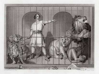
Sold2022Sir Edwin Henry Landseer Van Amburgh and the Lions 1879 engravingSir Edwin Henry Landseer. (English, 1802-1873). Van Amburgh and the Lions. Antique steel engraving on thick wove paper after the original oil on canvas by master engravers A. C. Alais and W. J. AlaisSee Sold Price
Sold2024Chart Of The World According To Mercators Projection Showing Tracks & Discoveries Of Capt. CookPublished by Wilkie & Robinson, J Mawman, and the other propietors, engraved for Guthries new system of geographySee Sold Price
Sold2017Map of The World On Mercators Projection, 1848Map: The World On Mercators Projection Size: Folio – 11.00 H x 13.20 W Inches Publisher: Orr & Sons & J. Morrison 1848 London/Glasgow From Edinburgh General Atlas. Shows Texas labeled in the North ASee Sold Price
Sold2021WWI "The Great Victory Generals of the World" CalendarCanadian. 1910s. Lithographed paper. Features Field Marshal Sir Douglas Haig, Marshal Ferdinand Foch, General John J. Pershing and General Armando Diaz each holding a flag of their Country. Marked, "4See Sold Price
Sold2021Double hemisphere world map with additionalTitle: Double hemisphere world map with additional projections. 1752 by Homann Heirs Date/Period: 1762 Materials: Copperplate engraved Size: 24 x 20 1/2 1762, by J. B. Homann & Homann Heirs, from "AtlSee Sold Price
Sold2019North America.Title: North America. Publication Date: 1893 Cartographer: LOWRY, J. W. ? Publisher: BLACKIE & SON Size: 19.6Height - 13.3Width Map from The Descriptive Atlas of the World. No.48. Polar projection. MaSee Sold Price
2022Francis Newton Souza Gentleman Pastel DrawingNew York, India, England,1924-2002 Depicts a bald man dressed in brown against a vibrant orange background. Souza studied at the at the Sir J.J. School of Art in Mumbai but was expelled for participatSee Sold Price
Sold2024A lot of three publications on pendulums and the determination of longitudeA lot of three publications on pendulums and the determination of longitude, including J.F.W. Herschel's Philosophical Transactions paper "Account of A Series of Observations, Made in 1825, for the puSee Sold Price
Sold2024Stone Age Scandinavian Type Lozenge-Shaped Pierced Battle AxeheadNeolithic Period, 4th-3rd millennium B.C. With slightly convex cutting edge, second edge to butt. Cf. Evans, Sir J., Ancient Stone Implements of Great Britain, 2nd edition, 1897, items 55, 56, 66. 1.0See Sold Price
Sold2021History of the World by Sir Walter Ralegh 1614 1stThe History of the World In Five Books by Sir Walter Ralegh (Raleigh). 1614. At London Printed for Walter Burre. 669 pp. Includes engraved title page; frontispiece and 8 maps with Chronological TableSee Sold Price
Sold2021Sir Alfred J. Munnings - Racing Drawings (2)Sir Alfred J. Munnings - British, 1878-1959 Racing Drawings (2) Pencil 4" x 6" 2 double sided drawings presented in on frame (4 drawings in all) Provenance: Frost and ReedSee Sold Price
Jun 12Leland LittleAttributed Sir John Watson Gordon (Scottish, 1788-1864), Portrait of Louisa Fearns$50
Jun 12Leland LittleThomas Luny (British, 1759-1837), Battle of Tory Island, 12th October 1798$850(4 bids)
2 days LeftPlakas AuctionsB. PRABHA (1933-2001) "LADY WITH BIRD" SIGNED TOP LEFT, OIL ON CANVAS£3,000
2 days LeftPlakas AuctionsB.PRABHA (1933-2001) "UNTITLED" FISHERWOMAN, SIGNED TOP LEFT, OIL ON CANVAS£6,000
Jun 13Swann Auction Galleries(WORLD.) Henry Teesdale; and John Dower (engraver). A New Chart of the World$1,500
3 days LeftRay's Premier AuctionAnimete Creation "Our Living World" by The Rev. J. G. Wood. 6 Volume Set. Hardcover.$10
5 hrs LeftJasper521660 HISTORY of the WORLD by WALTER RALEIGH antique ILLUSTRATED w/ MAPS English$700
208 Lots AwayHermann Historica GmbHFranz Poledne (1873 - 1932) - Russian Corporal in First World War, 1915 - 1917See Sold Price
3 days LeftFreeman's | HindmanAn archive of ephemeral materials from the World Science Fiction Convention. Roughly 1939-1991.$350
3 days LeftFreeman's | HindmanAward given to Forrest J. Ackerman by Isaac Asimov at the 11th WorldCon. 1953. FIRST HUGO EVER$2,500
3 days LeftFreeman's | HindmanSouvenir program booklet for Fourth Annual World Science Fiction Convention. 1946. SIGNED BY$250
3 days LeftFreeman's | HindmanBERGERAC, Cyrano de. Selenarchia. Or, the Government of the World in the Moon: A Comical History.$2,250
4 days LeftSimpson Galleries, LLC.AN AMERICAN CIVIL WAR ERA ATLAS, "Johnson's New Illustrated Family Atlas of the World with Physical$300
3 days LeftFreeman's | HindmanMURCHISON, Roderick Impey, Sir. The Silurian System. 1839. COMPLETE WITH VERY RARE HAND-COLORED$1,500
3 days LeftFreeman's | HindmanNUETZELL, Albert. Original artwork for the cover of an unidentified issue of Fantastic Adventures.$250(3 bids)


![Annals & Memoirs Of The Court Of Peking: Annals & Memoirs Of The Court Of Peking (From The 16th To The 20th Century). BACKHOUSE, Sir E[dmund] [1873-1944] & J.O.P.BLAND. Published by London: William Heinemann, [1914]. 8vo. pp. x, 531, [1]. ti](https://p1.liveauctioneers.com/4247/86181/44316835_1_x.jpg?height=310&quality=70&version=1457738399)


![[LIVINGSTONE, David, Dr. (1813-1873), association]. KIRK, J...: [LIVINGSTONE, David, Dr. (1813-1873), association]. KIRK, John, Sir (1832-1922). Autograph letter signed (“John Kirk”) to Mrs. Carnegie, 30 January 1868. 2-page bifolium, 8vo, signed on in](https://p1.liveauctioneers.com/928/301544/160920939_1_x.jpg?height=310&quality=70&version=1694462960)