Sold2017de la Rochette/Faden: Antique Map Lesser Antilles, 1784Map: A Chart of the Antilles, or: Charibbee, or: Caribs Islands, with the Virgin Isles Cartographer: De la Rochette/Faden Place & Date: London / 1784 Size: 18" x 20 3/8" Condition: b&w (except for wasSee Sold Price
Sold2018Antique Chart Of The Antilles Of The CaribbeanFrame: 24.25" x 21 1/8". Image sight: 22 5/8" x 19 5/8". Reproduction of a chart of the Antilles or Charibee or Caribs islands with the virgin isles by LS de la Rochette. London published by William FSee Sold Price
Sold2018Important Taino Three Pointer Stone Zemi FigurePre-Columbian, Hispaniola, Greater Antilles Islands, Taino/ Arawak Indians, ca. 1000 to 1500 CE. Among the only items specifically referenced by Spanish chroniclers of the 15th century. Classically foSee Sold Price
Sold2018Incredible Taino Stone Dagger - Stylized Serpent**Originally Listed At $6000** Pre-Columbian, Hispaniola, Greater Antilles Islands, Taino/ Arawak Indians, ca. 1000 to 1500 CE. Gorgeous light green stone ceremonial dagger or scepter in the form of aSee Sold Price
Sold2018Pre-Columbian Taino Stone ZemiHispaniola, Greater Antilles Islands, Taino/ Arawak Indians, ca. 1000-1500 CE. This striking example features a stylized anthropomorphic face that depicts a skull-like human face with circular sunkenSee Sold Price
Sold2017Exceptional Taino Stone ZemiPre-Columbian, Hispaniola, Greater Antilles Islands, Taino/ Arawak Indians, ca. 1000 to 1500 CE. Among the only items specifically referenced by Spanish chroniclers of the 15th century, a quintessentiSee Sold Price
Sold2023Taino Stone Three Pointed Zemi Figure**First Time At Auction** Pre-Columbian, Hispaniola, Greater Antilles Islands, Taino/ Arawak Indians, ca. 1000 to 1500 CE. Among the only items specifically referenced by Spanish chroniclers of the 15See Sold Price
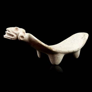
Sold2018Pre-Columbian Taino Stone DuhoPre-Columbian Taino Stone Duho from Hispaniola, Greater Antilles Islands, Taino/ Arawak Indians, ca. 1000-1500 CE. Carved stone duho depicting a stylized anthropomorphic face that depicts a skull-likeSee Sold Price
Sold2018Pre-Columbian Taino Stone ZemiHispaniola, Greater Antilles Islands, Taino/ Arawak Indians, ca. 1000-1500 CE. This striking example features a stylized anthropomorphic face that depicts a skull-like human face with circular sunkenSee Sold Price
Sold2023Taino Stone Zemi Figure, 3-Pointed TrigonolithPre-Columbian, Hispaniola, Greater Antilles Islands, Taino / Arawak Indians, ca. 1000 to 1500 CE. A remarkably well-preserved stone zemi figure presenting in a traditional 3-pointed form known as a trSee Sold Price
Sold2018Pre-Columbian Fully Carved Human Effigy Monolithic AxPre-Columbian Fully Carved Human Effigy Monolithic Style Ax Fully Carved Human Effigy Monolithic Style Ax, Pre-Columbian, Puerto Rico, Greater Antilles Islands, Taino/ Arawak Indians, ca. 1000 to 1500See Sold Price
Sold2018Per-Columbian Fully Carved Cemi IdolPer-Columbian Fully Carved Cemi Idol Fully Carved Cemi Idol, Pre-Columbian, Puerto Rico, Greater Antilles Islands, Taino/ Arawak Indians, ca. 1000 to 1500 CE. EX. Ed Lucas Collection 1949 (1000-1500 CSee Sold Price
Sold2018Pre-Columbian Carved Double Human Effigy Cemi IdolPre-Columbian Fully Carved Double Human Effigy Cemi Idol Fully Carved Double Human Effigy Cemi Idol, Pre-Columbian, Puerto Rico, Greater Antilles Islands, Taino/ Arawak Indians, ca. 1000 to 1500 CE. ESee Sold Price
Sold2022Carte des Iles Antilles par J. B Poirson, 1802Property from the Collection of John and Virginia Duncan, Savannah, GA Description: Carte des Iles Antilles par J. B Poirson, 1802, Hand Colored Engraving, French map of the Antilles Islands, J. BSee Sold Price
Sold2023West Indies. Caribbean islands Antilles Gulf of Mexico Florida. THOMSON 1830 mapTitle: West Indies. Caribbean islands Antilles Gulf of Mexico Florida. THOMSON 1830 map Description: West Indies' by Drawn & engraved for John Thomson's "New General Atlas" (1830). Antique early 19thSee Sold Price
Sold2019WEST INDIA ISLANDS. Caribbean Indies Antilles Bahamas.TITLE/CONTENT OF MAP: 'West India Islands' Show the West Indies, Antilles, Windward Islands, Leeward Islands, Cuba, the Bahamas, Hispaniola, Turks & Caicos Islands. Vignettes: Kingston, Jamaica, fromSee Sold Price
Sold2018BRITISH WEST INDIES ISLANDS. Jamaica Antilles VirginTITLE/CONTENT OF MAP: 'THE BRITISH ISLANDS IN THE WEST INDIES; Jamaica, Trinidad, Virgin Islands, Leeward Islands (St Christopher, Nevis, Barbuda, Antigua), St Lucie, St Vincent, Barbadoes, Tobago, DoSee Sold Price
Sold2024LESSER ANTILLES. Windward & Leeward islands. Puerto Rico. Trinidad 1947 mapTITLE/CONTENT OF MAP: 'Lesser Antilles inset Puerto Rico, Trinidad' DATE PRINTED: 1947 IMAGE SIZE: Approx 22.5 x 33.5cm, 8.75 x 13.25 inches (Large) TYPE: Vintage colour atlas map CONDITION: Good; suiSee Sold Price
Sold20204-ASSORTED 1ST DAY ISSUE ENVELOPES WITH STAMPSON INFO CARDS ST. CHRISTOPHER-NEVIS-ANGUILLA, NEPAL, NETHERLANDS ANTILLES AND NORFOLK ISLANDSee Sold Price
Sold2023WEST INDIA ISLANDS'. Caribbean Indies Antilles Bahamas. TALLIS/RAPKIN 1851 mapTitle: WEST INDIA ISLANDS'. Caribbean Indies Antilles Bahamas. TALLIS/RAPKIN 1851 map Description: West India Islands' by Map drawn and engraved by J. Rapkin; vignette illustrations drawn by H WarrenSee Sold Price
Sold2023Johnson's West Indies. Bermuda Islands. Caribbean Bahamas Antilles 1866 mapTitle: Johnson's West Indies. Bermuda Islands. Caribbean Bahamas Antilles 1866 map Description: Johnson's West Indies // The Bermuda Islands' by Alvin Jewett Johnson (1866). Large, decorative hand colSee Sold Price
Sold2018Antilles, Or West India IslandsTitle/Content of Map: Antilles, Or West India Islands Date Printed: 1893 ca. Cartographer: FISK & CO. Size: 9.25X12.25 Montreal plan on reverse. From The Columbian Atlas of the world we live in. MargiSee Sold Price
Sold2017Virgin Islands to Margarita Island, Venezuela Map, 1680Isles d'Amerique dites Caribes et Antilles et de Barlovento. A beautifully colored exemplar of Du Val's uncommon map of the Lesser Antilles from the Virgin Islands to Margarita Island off the coast ofSee Sold Price
Sold2019WEST INDIES Antilles Caribbean Cuba Bahamas WindwardTITLE/CONTENT OF MAP: 'THE ANTILLES OR WEST INDIA ISLANDS' DATE PRINTED: 1874 IMAGE SIZE: Approx 32.5 x 42.0cm, 12.75 x 16.5 inches (Large) TYPE: Antique steel engraved map with original outline handSee Sold Price
3 days LeftTremont AuctionsJoseph Mellor Hanson. 1956. Matinicus Island, Maine. "Matinicus and Her Satelites". Coastal seascape$200(1 bid)
Echoes of Glory International Military Auction HouseWWII Bringback Philippine Islands Native Cleaver Machete (A)$35(2 bids)
4 days LeftSchilb Antiquarian Rare Books1848 1ed Wreck of the Glide Fiji & Wallis Islands Native Shipwrecks Dix Oliver$4(2 bids)
4 days LeftPeterborough Auctions LLCA Massim Betelnut Mortar and Pestle, Trobriand Islands, Papua New Guinea$50
Jun 14DuMouchellesJim Dine (American, B. 1935) Offset Lithographs on Paper, Ca. 1981-82, "Cape And Islands Chamber$50
Jun 14DuMouchellesJim Dine (American, B. 1935) Offset Lithographs on Paper, Ca. 1980, "Cape And Islands Chamber Music$50
3 days LeftTrillium Antique Prints & Rare BooksPrevost - Chart of the Islands of Java, Sumatra, Borneo, &c.$50
4 days LeftSuccetti GalleryTwo Solomon Islands Barbed Spear. Wood, fiber, cord. They measure 34 3/4 inches and 34 1/2 inches$175