Sold2023Weller, F. S. 1894 Antique Map. Berlin and EnvironsLithograph Map Published 1891-94 by Cassell & Co., London for "Cassell's Encyclopaedia A Storehouse of General Information" by Various Authors. Map by F. S. Weller. Folds as issued. Paper Size: 11 x 9See Sold Price
Sold20211860 Ettling Map of United States -- United States ofTitle: 1860 Ettling Map of United States -- United States of North America (Eastern & Central) Cartographer: T Ettling Year / Place: 1860 c., London Map Dimension (in.): 33.5 X 35.5 in. joined This isSee Sold Price
Sold2017Hardy: Antique New York City Fire Department Map, 1871Title: 1871 Hardy New York City Fire Department Map -- Map of the Boundaries of the Fire Department of the City of New York Made Under the Direction of the Fire Commissioners Cartographer: J Hardy YeaSee Sold Price
Sold2017Ettling: Map of United States of North America, 1860United States of North America (Eastern & Central) T. J. Ettling, c1860 17 x 25. This great Civil War era map covers the country from the Rocky Mountains to the Atlantic seaboard. The map is engravedSee Sold Price
Sold2022Moule, Thomas C1845 British Map. Environs of LondonSteel Engraved Map Published C1845, London for "A Complete and Universal English Dictionary" by the Rev. James Barclay et al. Maps by Thomas Moule. Paper Size: 10.5 x 8 inch (27 x 21cm) Good ConditionSee Sold Price
Sold2023Moule, Thomas C1840 British Map. Environs of LondonSteel Engraved Map Published C1840, London for "A Complete and Universal English Dictionary" by the Rev. James Barclay et al. Maps by Thomas Moule. Paper Size: 10.5 x 8 inch (27 x 21cm) Small top margSee Sold Price
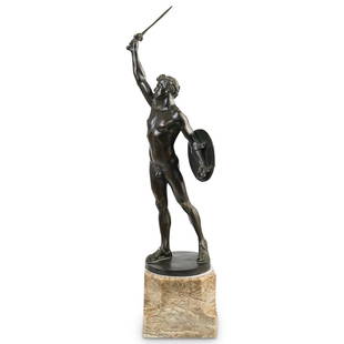
Sold2021Eug. Wagner "Gladiator in Victory Pose" BronzeDESCRIPTION: Eugen Wagner (Berlin 1871-1942) Bronze Sculpture Gladiator in Victory Pose. This is a bronze with dark patina sculpture on a marble base. Signed Eug. Wagner Berlin. Eugen Wagner was a gerSee Sold Price
Sold2017Bronze of Prometheus and eagle by Gotthilf JaegerBronze of Prometheus and eagle by Gotthilf Jaeger.(From Askart)"Gotthilf Jaeger was a sculptor in Berlin (1871 Cologne - 1933 Berlin), studied at the Academy in Karlsruhe Volz and at Städel InstituteSee Sold Price
Sold202219TH CENT WATERCOLOR MAP OF THE UNITED STATES19TH CENT N.E. WATERCOLOR MAP OF THE UNITED STATES BY R.P. DCALON? BERLIN MAR 27TH 1824 - PROB SCHOOLGIRL-BOY MAP BERLIN MA OR NH - BACK MATTED & FRAMED - 14 7/8" X 18 7/8" - TONING, CREASES & IMPERFESee Sold Price
Sold20201871 Colton Map of Missouri -- Colton's Dollar SeriesTitle/Content of Map: 1871 Colton Map of Missouri -- Colton's Dollar Series of Sectional Maps. Missouri Cartographer: GW & CB Colton Year/Place: 1871, New York Size: 26.9 X 29.9 in. This is a superb fSee Sold Price
Sold20181871 Mitchell Antique Map of AlaskaTitle/Content of Map: 1871 Mitchell Map of Alaska -- North Western America Showing the Territory Ceded by Russia to the United States Date Printed: 1871, Philadelphia Cartographer: S Mitchell Size: 11See Sold Price
Sold20181871 Mitchell Map of Texas -- XIII TexasTitle/Content of Map: 1871 Mitchell Map of Texas -- XIII Texas Date Printed: 1871, Philadelphia Cartographer: S Mitchell / Butler Co. Size: 8.3 x 10.5 in. This is very nice map of Texas, part of a schSee Sold Price
Sold2019BERLIN antique town city map plan. Fortifications.TITLE/CONTENT OF MAP: 'BERLIN.' The top image on the right hand side shows the entire map. To view a close up of the map showing the level of printed detail, please click on the bottom image on the riSee Sold Price
Sold20201871 Hardy Map on New York City Police Districts andTitle/Content of Map: 1871 Hardy Map on New York City Police Districts and Precincts -- Map of the County of New York Showing the Wards and Police Precincts and Location of Station Houses CartographerSee Sold Price
Sold20181871 Hardy New York City Fire Department Map -- Map ofTitle/Content of Map: 1871 Hardy New York City Fire Department Map -- Map of the Boundaries of the Fire Department of the City of New York Made Under the Direction of the Fire Commissioners Date PrintSee Sold Price
Sold20181871 Mitchell Map of Dakotas, Nebraska, Kansas,Title/Content of Map: 1871 Mitchell Map of Dakotas, Nebraska, Kansas, Colorado and Wyoming -- County Map of Dakota, Wyoming, Kansas, Nebraska and Colorado Date: 1871, Philadelphia Cartographer: S MitcSee Sold Price
Sold2018Mitchell: Antique Map of New Orleans, 1871Title/Content of Map: 1871 Mitchell Map of New Orleans -- Plan of New Orleans Date Printed: 1871, Philadelphia Cartographer: S Mitchell Size: 9.3 x 10.9 in. An excellent map of the Crescent City, showSee Sold Price
Sold2024EUROPEAN CITIES. London Edinburgh Madrid Lisbon Dublin. JOHNSTON 1900 old mapTITLE/CONTENT OF MAP: 'Environs of London; environs of Dublin; Edinburgh and environs; Madrid; Lisbon and environs' DATE PRINTED: 1900 IMAGE SIZE: Approx 20.0 x 26.5cm, 8 x 10.5 inches (Medium) TYPE:See Sold Price
Sold20181871 Chicago Fire Harper's Weekly Colored Photos --Title/Content of Map: 1871 Chicago Fire Harper's Weekly Colored Photos -- Harper's weekly, Nov. 4, 1871; Chicago Fire Date: 1871 New York Cartographer: Harper's Weekly Size: 11 X 16 in. each sheet, doSee Sold Price
Sold2023Map of Environs de Paris drawn by Ch LaCoste and engraved by RaymondMap of Environs de Paris et ses forts, originally drawn by Ch LaCoste and engraved by Raymond. Overall: 20" h x 26" w Sight size: 13" h x 18" wSee Sold Price
Sold2022Liebmann, Alexander (1871 Berlin - 1942 München) - "Garmisch", Farbradierung, stellenweise inLiebmann, Alexander (1871 Berlin - 1942 München) - "Garmisch", Farbradierung, stellenweise in Weiß koloriert, in der Platte signiert und betitelt, unter der Darstellung in Blei handsigniert,See Sold Price
Sold20181871 MAP OF BULLS BAYAntique 1871 Map of the Entrance to Bull and Combahee Rivers, South Carolina. U.S. Coast survey Benjamin Peirce Superintendent entrance to Bull and Combahee rivers South Carolina 1871. This original nSee Sold Price
2018Ettling: Antique Map of USA SOUTH EAST, 1863TITLE/CONTENT OF MAP: 'United States of North America (Eastern & central)' USA SOUTH EAST. Florida Georgia Carolina coast Bahamas DATE PRINTED: 1863 IMAGE SIZE: Approx 44.5 x 32.0cm, 17.5 x 12.5 incheSee Sold Price
Sold2023NORTHERN CENTRAL AMERICA. Mexico Belize Guatemala Honduras. ETTLING 1863 mapCentral America (Northern Part) Comprising Mexico, Guatemala, Honduras, San Salvador and Nicaragua' by Drawn & Engraved by T. Ettling (1863). Antique map with original outline colour, 31.5 x 44.0cm, 1See Sold Price
7 days LeftJasper521754 but early 1800s Delagrive Map of Paris Environs in Reduced Size -- Reduction des neuf feuilles$60
Jun 23Treasure Quest AuctionsPr. Child's Ulster County, NY 1871-72 Gazetteer & Business Directories$50
Featured7 days LeftJasper52St. Paul, Minneapolis and Environs Rand, McNally & Co's Business Atlas Map of St. Paul And$60
4 days LeftSchilb Antiquarian Rare Books1871 Alfred the Great King of England MAP Battle of Ashdown Vikings Thom Hughes$125(3 bids)
13 hrs LeftJasper52S AMERICA CITIES. Buenos Aires Rio de Janeiro Valparaiso Lima. JOHNSTON 1900 map$35
13 hrs LeftJasper52S AMERICA CITIES. Buenos Aires Rio de Janeiro Valparaiso Lima. JOHNSTON 1906 map$35
13 hrs LeftJasper52S AMERICA CITIES. Buenos Aires Rio de Janeiro Valparaiso Lima. JOHNSTON 1910 map$40
7 days LeftJasper52Cincinnati and Environs. Rand, McNally & Co's New Business Atlas of America Map of Cincinnati.$40
Jun 07Freeman's | HindmanMURCHISON, Roderick Impey, Sir. The Silurian System. 1839. COMPLETE WITH VERY RARE HAND-COLORED$1,500
4 days LeftSchilb Antiquarian Rare Books1871 Holy BIBLE & MAPS Holy Land Hitchcock Analysis Gruden Concordance Theology$120(3 bids)