Sold2024Arid Regions and Closed River Basins of Asia. Sketch map 1885 old antiqueTITLE/CONTENT OF MAP: 'Arid Regions and Closed Basins of Asia' DATE PRINTED: 1885 IMAGE SIZE: Approx 12.0 x 12.0cm, 4.75 x 4.75 inches (Small) TYPE: Antique engraved sketch map CONDITION: Good; suitabSee Sold Price
Sold2024Middle East ethnic divisions. South west Asia. Sketch map 1885 old antiqueTITLE/CONTENT OF MAP: 'Ethnical Divisions of Hither Asia' DATE PRINTED: 1885 IMAGE SIZE: Approx 12.0 x 11.0cm, 4.75 x 4.5 inches (Small) TYPE: Antique engraved sketch map CONDITION: Good; suitable forSee Sold Price
Sold2024The Absheron Peninsula. Azerbaijan. Sketch map 1885 old antique plan chartTITLE/CONTENT OF MAP: 'The Apsheron Peninsula' DATE PRINTED: 1885 IMAGE SIZE: Approx 10.5 x 12.0cm, 4 x 4.5 inches (Small) TYPE: Antique engraved sketch map CONDITION: Good; suitable for framing. PleaSee Sold Price
Sold2024Isothermal Lines of Africa. Sketch map 1885 old antique vintage plan chartTITLE/CONTENT OF MAP: 'Isothermal Lines of Africa' DATE PRINTED: 1885 IMAGE SIZE: Approx 13.5 x 12.0cm, 5.25 x 4.75 inches (Small) TYPE: Antique engraved sketch map CONDITION: Good; suitable for framiSee Sold Price
Sold2024North East Africa 1885 old antique vintage map plan chartTITLE/CONTENT OF MAP: 'North East Africa' DATE PRINTED: 1885 IMAGE SIZE: Approx 31.5 x 23.0cm, 12.5 x 9 inches (Large); Please note that this is a folding map. TYPE: Antique colour map CONDITION: GoodSee Sold Price
Sold2019MAP - Ukraine. MercatorUkraine. Mercator/Hondius, Taurica Chersonesus, 1613 (published). Hand Color. Lovely miniature map of the region north of the Black Sea encompassing the Crimea and the southern steppes of Ukraine. TheSee Sold Price
Sold2023Collection of Maps on North & South AmericasA collection of vintage maps of North and South Americas, some old, some newer, some color, hand colored, and black and white, including Manhattan, United States, South America, and some Caribbean IslSee Sold Price
Sold2020Six Titles on N.C. Revolutionary War Historyincluding [Interesting Revolutionary Incidents: and Sketches of Character, Chiefly in the "Old North State"] by the Rev. E. W. Caruthers, D. D., Philadelphia: Hayes & Zell, 1856, bound in blind stampSee Sold Price
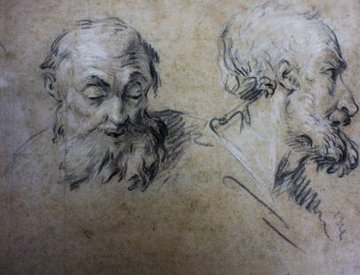
Sold2016Falconet(after); 19thC. Charcoal SketchCharcoal on paper. Sketch - Old Man. After Falconet; 8.75in. X 11.75in.(image size)See Sold Price
Sold2022Return of the Native first edition in book formHeading: Author: Hardy, Thomas Title: The Return of the Native Place Published: London Publisher:Smith, Elder, & Co. Date Published: 1878 Description: 3 volumes. FrontispieSee Sold Price
Sold2023Fragment from the Old North Church in BostonCarved wooden decorative element from the Old North Church in Boston with old note on reverse pencil inscribed "This came from the Old North Church in Boston where Paul Revere hung out the lantern. ISee Sold Price
Sold2023OLD NORTH BRIDGE / CONCORD MASS RELICOak cane with gold-filled handle engraved "Old North Bridge Oak Concord, MA Sept 12 '85. 37 inches.See Sold Price
Sold2022Faden - United States of North America, MapWilliam Faden, (1749-1836), The United States of North America: with the British territories and those of Spain..., London, 1796, "Published as the Act directs, Feby. 11, 1796, by Willm. Faden, GeograSee Sold Price
Sold2024CHINA & JAPAN showing Opium Wars battlefields & dates. JOHNSTON 1913 old mapCAPTION PRINTED BELOW PICTURE: 'China and Japan // Islands of Japan' DATE PRINTED: 1913 IMAGE SIZE: Approx 34.5 x 43.5cm, 13.5 x 17.25 inches (Large); Please note that this is a folding map. TYPE: AntSee Sold Price
Sold2017LARGE LOT OF OLD MAPSINCLUDES LANDMARK MAPMAKING BOOK. LARGE VARIETY OF MAPS.maps are old, some are taped to boards, very fragile, and/or torn/cracking. ***Additional photo links available at http://paceantiques.com/See Sold Price
Sold2022Three 18th Century North Carolina Mapsengravings on laid paper, all unframed, including: John Reid, The State of North Carolina From the Best Authorities, engraver Benjamin Tanner, New York, circa 1796, sheet 16-1/2 x 19 in.; Matthew CareSee Sold Price
Sold2017KURT SCHWITTERS (GERMANY/UK 1887-1948) "MERZ", COLLAGEKURT SCHWITTERS (GERMANY/UK 1887-1948) "MERZ", COLLAGE ON PAPER LAID ON OLD SKETCH BOOK COVER MARKED Z. BAZIN, "FRANKFURTS", SIGNED AND TITLED. SIGHT 11 3/4 X 9"; FRAMED AND GLAZED-14 1/4 X 11 1/2"See Sold Price
Sold2024Willem Blaeu, Map of The AmericasAmsterdam, 1617. Together with "Early Maps" by Tony Campbell, Abbeville Press and "The United States in Old Maps and Prints, Eduard Van Ermen. 3 pieces Sight size: 16-1/2"h x 22"w Overall: 23-1/2"h xSee Sold Price
Sold2016Ming Dynasty Chinese Jade Dragon Belt PlaqueMing Dynasty Chinese Jade Dragon Large Belt Plaque, pierced and engraved with a dragon in vegetation on several layers. Age related wear. Width 5 3/8 inches (13.6 cm.). Provenance: Old North Shore LonSee Sold Price
Sold2023Paula North - Oil on CanvasA large oil on canvas by Paula North. Titled 'Old Montauk Highway.' Signed and titled on stretcher. Circa 1981. 50 x 72 . Measurements are in inches. (Height x Width x Depth)See Sold Price
Sold2024DORIS & RICHARD BEER (Massachusetts, Mid-20th Century), Eight views of Nantucket, Massachusetts:,DORIS & RICHARD BEERMassachusetts, Mid-20th CenturyEight views of Nantucket, Massachusetts: 1) Macy House.2) Orange Street.3) Corner Stores.4) Stone Alley.5) Old Custom House.6) Old North Slip.<See Sold Price
Sold2022Doris and Richard Beer Trio of Nantucket Watercolors Framed TogetherDoris and Richard Beer (American 1898-1967 & 1893-1959) Trio of Nantucket Watercolors Framed Together: Old North Wharf, Orange Street and Straight Wharf, matted and framed 3.75 in. x 4.25 in. FramSee Sold Price
Sold2021Four Doris and Richard Beer Nantucket WatercolorsFour Doris and Richard Beer Nantucket Watercolors, unframed, each pencil signed lower right, "D&R Beer", and pencil titled lower left, "Old North Wharf, Orange Street, Town, and Old Customs House". OnSee Sold Price
Sold2022Art Drawing Book Attributed to Jean-Michel BasquiatArt book attributed to Jean-Michel Basquiat, dated between 1980-81. There are a total of 82 sketches and drawings in the book and an additional 7 drawings & sketches on old composition paper. The mediSee Sold Price
1 day LeftJasper52AFRICAN ISLANDS.Mauritius Madagascar Madeira Canaries St Helena 1897 old map$20(1 bid)
11 hrs LeftJasper521775-1780 North & South Carolina, Georgia and Virginia. By Bonne & Raynal$180(2 bids)
3 days LeftFreeman's | Hindman[MAP]. TODESCHI, Pietro. [Nova et Acurata Totius Americae Tabula auct. G.I. Blaeu] America quarta$5,000
5 days LeftThe North Georgia Auction Company LLCClint Alderman Edgefield Area Potteries Map$200(1 bid)
5 days LeftThe North Georgia Auction Company LLCCarol Salas Meader's Homeplace Folk Art Painting$170(2 bids)
5 days LeftThe North Georgia Auction Company LLCVery Old Wooden Spoon Rack / Kitchen Utensil Rack Holder$60(2 bids)
5 days LeftThe North Georgia Auction Company LLCPair Very Old Albany FDY Co #170 Ship Door Stop / Book Ends$25(1 bid)


![Six Titles on N.C. Revolutionary War History: including [Interesting Revolutionary Incidents: and Sketches of Character, Chiefly in the "Old North State"] by the Rev. E. W. Caruthers, D. D., Philadelphia: Hayes & Zell, 1856, bound in blind stamp](https://p1.liveauctioneers.com/33/158598/80103809_1_x.jpg?height=310&quality=70&version=1577815127)


![[MAP]. TODESCHI, Pietro. [Nova et Acurata Totius Americae Tabula auct. G.I. Blaeu] America quarta (1 of 1)](https://p1.liveauctioneers.com/197/329395/177650542_1_x.jpg?height=282&quality=70&version=1715364962)


