Sold20221818 Map I Stati Uniti Nell America SettentrionaleHistoric Maps 1818 Rare Map Titled "I Stati Uniti Nell' America Settentrionale" by A.B. Borghi, Florence, Italy Choice Crisp Near Mint 1818-Dated, Four-Sheet Copper-Engraved, Hand-Colored Outlines, MaSee Sold Price
Sold2024Tasso Italian Map the United States 1832TASSO, G. (19th Century). Stati-Uniti dell' America Settentrionale dalle Piu Recenti Mappe... Engraved map with original hand color. Venice, 1832. 15 1/4" x 19 3/4" sheet. Scarce map from an Italian eSee Sold Price
Sold2017Passaporto per gli USA - Nicholas BrownPassaporto per gli Stati Uniti d'America rilasciato durante la Repubblica Romana da Nicholas Brown (con sua annotazione e firma autografa). Datato 4 luglio 1849. Testo a stampa con indicazioni manoscrSee Sold Price
Sold20231832 map showing U.S. expansion westHeading: (United States) Author: Tasso, G. Title: Stati-Uniti dell' America Settentrionale dalle Piu Recenti Mappe... Place Published: Venice Publisher: Date Published: 1832 DescriptionSee Sold Price
Sold2023"America settentrionale ed Indie Occidentali" Ca. 1815.“America settentrionale ed Indie Occidentali” Ca 1815. Unknown creator. Hand-colored. The map features most of North America and the Atlantic & Pacific Oceans. The map key is located in thSee Sold Price
Sold2016[STATI UNITI] 1969 (10 dic.) Cosmogramma, uno degli 87[STATI UNITI] 1969 (10 dic.) Cosmogramma, uno degli 87 preparati per la missione spaziale Apollo 12, ma per motivi tecnici non imbarcati e restituiti dopo un periodo di quarantena al capitano della miSee Sold Price
Sold2016[STATI UNITI] 1969 (16 lug.) Spazio, "Insurance Cover",[STATI UNITI] 1969 (16 lug.) Spazio, "Insurance Cover", busta firmata prima della partenza, dai membri dell'equipaggio della storica missione Apollo 11, che portÚ per la prima volta un uomo sulla LSee Sold Price
Sold2016[STATI UNITI] 1969 (16 lug.)/1984 (20 lug.) Spazio,[STATI UNITI] 1969 (16 lug.)/1984 (20 lug.) Spazio, "Insurance Cover", busta firmata prima della partenza, dai membri dell'equipaggio della storica missione Apollo 11, che portÚ per la prima voltaSee Sold Price
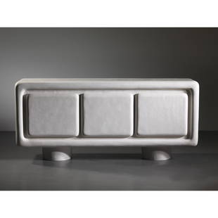
Sold2023Kelly Wearstler (Myrtle Beach 1967) COLINA CREDENZAKelly Wearstler(Myrtle Beach, 1967) COLINA CREDENZA, WHITE RESIN AND WALNUT WOOD INTERIOR CREDENZA MODELLO COLINAin resina bianca modellata a mano e interni in legno di noceProduzione Stati Uniti, 201See Sold Price
Sold2020VLADIMIR KAGAN (Attr.). Wooden and cotton sofaVLADIMIR KAGAN (Attr.) (Worms, 1927 - Palm Beach, 2016). Divano in legno e cotone. Stati Uniti. Anni '50. Mis. Lung. cm. 255 Alt. cm. 79 Prof. cm. 86 ca. Val. 3500/4500See Sold Price
Sold2017Caraffa in argento con corpo di sezione rettangolareCaraffa in argento con corpo di sezione rettangolare sagomato, sbalzato e cesellato con decori floreali; manico ad ansa scanalato. Stati Uniti, argentiere Tiffany & Co, 1875-91 (pattern number 5816; oSee Sold Price
2020Two mahogany armchairsDue poltrone in mogano. Stati Uniti. Anni '80-'90. Mis. Lung. cm. 60 Alt. cm. 68 Prof. cm. 56 ca. Val. 3000/3500See Sold Price
Sold2022PAUL FRANKL. Pair of wooden coffee table. 1960sPAUL FRANKL (Praga, 1878 - Stati Uniti, 1962). Coppia di sgabelli in legno e sughero. Anni '60. Mis. Lung. cm. 75 Alt. cm. 43 Prof. cm. 44 ca. Val. 1500/2000See Sold Price
Sold2022CARAFFA E BACILE IN ARGENTO, SICILIA, XIX SECOLOa superficie liscia; caraffa e bacile sono stati uniti; difetti Alt. cm 28, larg. cm 18; peso gr 639 Alt. cm 9,5, diam. cm 32; peso gr 918 AN ITALIAN SILVER EWER AND BASIN, SICILY, 19TH CENTURY; DEFECSee Sold Price
Sold2017Antique Map of Central America & West Indies, 1845Map: Central America and the West Indies from the Best Authorities. With Republic of Texas Publication Date: 1845 Authors: HARPER & BROTHERS, CHARLES COPLEY (ENGRAVED BY) Publisher: HARPER & BROTHERSSee Sold Price
Sold20171860 Mitchell Mexico, Central America & West Indies Map1860 Map of Mexico, Central America and the West Indies, S. Augustus Mitchell. 13.25 x 21.13 inches. Authentic hand-colored antique map from Mitchell’s 1862 New General Atlas depicts Mexico, CentralSee Sold Price
Sold2017Mitchell: Map of Mexico, Central America & West IndiesItem: Map of Mexico, Central America, and the West Indies Maker: Samuel Augustus Mitchell Jr. Size: 21 x 13 Date: 1860 Samuel Augustus Mitchell (1790-1860) was an American geographer born in ConnectiSee Sold Price
Sold2017Mitchell: Mexico, Central America, & West Indies MapMexico, Central America, and the West Indies, 23.75 x 15.25 in, 1877, S. Augustus Mitchell Please note that this lot has a confidential reserve. When you leave a bid in advance of the auction, submitSee Sold Price
Sold20231892 Johnson Map of Caribbean and Central America -- West Indies and Central AmericaTitle: 1892 Johnson Map of Caribbean and Central America -- West Indies and Central America Cartographer: A J Johnson Year / Place: 1892, New York Map Dimension (in.): 9.3 X 12.3 in. This is a ratherSee Sold Price
Sold2018Bartholomew: Map of Mexico Central America West IndiesTITLE/CONTENT OF MAP: 'Mexico, Central America, & West Indies; Inset maps of Mexico; Greytown; Jamaica; Havana; Panama; Barbuda; Santa Lucia' Panama & Proposed Nicaragua canal DATE PRINTED: 1901 IMAGESee Sold Price
Sold2023MEXICO CENTRAL AMERICA WEST INDIES. Panama & Proposed Nicaragua canals 1912 mapMexico, Central America & West Indies; Inset maps of Leeward & Windward Islands; Mexico; Matina Bay; Jamaica; Havana; Panama Canal;' by John Bartholomew & Co., Edin. (1912). Antique colour atlas map;See Sold Price
Sold2022Times Atlas 1895 Map. Central America & West IndiesLithograph Maps Published 1895, London for "The Times Atlas" Paper Size: 16 x 10.5 inch (41 x 27cm) Good ConditionSee Sold Price
Sold2018Mexico C. America, W. Indies Map 1939National Geographic magazine map: Mexico, Central America and the West Indies. Editor: Gilbert Grosvenor. Date: 1939. Measurement approximate: 41 x 23. Shipping cost: $15.00 excluding Hawaii, Alaska &See Sold Price
Sold2022Travel Collection of works on various regions, 18th-20th centuryTravel Collection of works on various regions, 18th-20th century comprising: [North America, West Indies, etc.].The Colonial Journal. Vol. I. January to July, 1816. London: Baldwin, Cradock, and Joy [See Sold Price
Jun 13Pandolfini Casa D'AstePhilip Baldwin e Monica Guggisberg COROLLA FLOOR LAMP, METAL STRUCTURE, GLASS LAMPSHADE€500
1 day LeftJasper521667 HERBARIO NOVO by Castore DURANTE antique PLANTS BOTANY FULLY ILLUSTRATED$1,100
Jun 14DuMouchellesJoseph Wilson Lowry (Bristish, 1803-1879) Hand Colored Engraving on Paper Ca. 19th Century, "West$10
5 days LeftTrillium Antique Prints & Rare BooksDobson - Map of the West Indies with part of Florida$50
Jun 20The Ross Art GroupOriginal Vintage Holland America Line Enjoy Your Trip by Eppo Doeve c1960$500
Jun 13Swann Auction Galleries(AMERICAS.) Robert Laurie; and James Whittle. A New Map of the Whole Continent of America,$450
7 days LeftWinter Associates Three historical engraved maps of the Caribbean, ranging from 1616-1814, each hand colored, framed$100(1 bid)
16 hrs LeftFreeman's | HindmanAlbert Lorey Groll (America, 1866–1952) - Western Plains$375(2 bids)
4 days LeftFreeman's | Hindman[MAP]. TODESCHI, Pietro. [Nova et Acurata Totius Americae Tabula auct. G.I. Blaeu] America quarta$5,000
4 days LeftDOYLE Auctioneers & AppraisersCarved and Painted Shadowbox Diorama of Provincetown, Massachusetts America, early 20th century$500(1 bid)
Jul 07A-1 Auction(2) 1864 Confederate States of America Loan Bond $1000 2nd & 3rd Series by E. Apperson$125(3 bids)
Jun 14Eldred'sWILLIAM & MARY HIGHBOY TOP CONVERTED TO A CHEST America, Late 18th Century Height 37.25". Width 37".$125
213 Lots AwayDenotter Auctions, LLCFranklin Mint People of Colonial America Fine Pewter Figures Set with Wood Case or Box$35(5 bids)
Jun 26Potter & Potter AuctionsISAACS, Ron (America, b. 1941). A Marriage. 2010. Acrylic t...$300(3 bids)


![[STATI UNITI] 1969 (10 dic.) Cosmogramma, uno degli 87: [STATI UNITI] 1969 (10 dic.) Cosmogramma, uno degli 87 preparati per la missione spaziale Apollo 12, ma per motivi tecnici non imbarcati e restituiti dopo un periodo di quarantena al capitano della mi](https://p1.liveauctioneers.com/3662/95918/48888262_1_x.jpg?height=310&quality=70&version=1478537255)
![[STATI UNITI] 1969 (16 lug.) Spazio, "Insurance Cover",: [STATI UNITI] 1969 (16 lug.) Spazio, "Insurance Cover", busta firmata prima della partenza, dai membri dell'equipaggio della storica missione Apollo 11, che portÚ per la prima volta un uomo sulla L](https://p1.liveauctioneers.com/3662/95918/48888258_1_x.jpg?height=310&quality=70&version=1478537255)
![[STATI UNITI] 1969 (16 lug.)/1984 (20 lug.) Spazio,: [STATI UNITI] 1969 (16 lug.)/1984 (20 lug.) Spazio, "Insurance Cover", busta firmata prima della partenza, dai membri dell'equipaggio della storica missione Apollo 11, che portÚ per la prima volta](https://p1.liveauctioneers.com/3662/95918/48888259_1_x.jpg?height=310&quality=70&version=1478537255)


![Travel Collection of works on various regions, 18th-20th century: Travel Collection of works on various regions, 18th-20th century comprising: [North America, West Indies, etc.].The Colonial Journal. Vol. I. January to July, 1816. London: Baldwin, Cradock, and Joy [](https://p1.liveauctioneers.com/94/251108/130828989_1_x.jpg?height=310&quality=70&version=1655281539)


![[MAP]. TODESCHI, Pietro. [Nova et Acurata Totius Americae Tabula auct. G.I. Blaeu] America quarta (1 of 1)](https://p1.liveauctioneers.com/197/329395/177650542_1_x.jpg?height=282&quality=70&version=1715364962)


