Sold2018SOUTHERN CENTRAL AMERICA. Mosquito New GranadaTITLE/CONTENT OF MAP: 'Central America (Southern Part) Including Venezuela & New Granada' Date: 1863 IMAGE SIZE: Approx 32.0 x 45.5cm, 12.5 x 18 inches (Large) TYPE: Antique map with original outlineSee Sold Price
Sold2019SOUTHERN CENTRAL AMERICA. Mosquito New GranadaTITLE/CONTENT OF MAP: 'Central America (Southern Part) Including Venezuela & New Granada' DATE PRINTED: 1862 IMAGE SIZE: Approx 32.0 x 45.5cm, 12.5 x 18 inches (Large) TYPE: Antique map with originalSee Sold Price
Sold2022Map of United States, JH Colton, ca 1849A framed map of the United States, Map of the United States of America, The British Provinces, Mexico, the West Indies and Central America with part of New Granada and Venezuela by JH Colton, ca 1849,See Sold Price
Sold2020Colton's 1849 wall map of United StatesHeading: Author: Colton, George Woolworth Title: Map of the United States of America, The British Provinces, Mexico, the West Indies and Central America with part of New Granada and Venezuela Place PSee Sold Price
Sold2022(GOLD RUSH.) J.M. Atwood. Map of the United States, Canada, Mexico, Central America, and the West(GOLD RUSH.) J.M. Atwood. Map of the United States, Canada, Mexico, Central America, and the West India Islands with a Portion of Venezuela & New Granada; Showing the Routes Overland and by the IsthmuSee Sold Price
Sold2023NORTHERN CENTRAL AMERICA. Mexico Belize Guatemala Honduras. ETTLING 1863 mapCentral America (Northern Part) Comprising Mexico, Guatemala, Honduras, San Salvador and Nicaragua' by Drawn & Engraved by T. Ettling (1863). Antique map with original outline colour, 31.5 x 44.0cm, 1See Sold Price
Sold2024NORTHERN CENTRAL AMERICA. Mexico Belize Guatemala Honduras. ETTLING 1863 mapTITLE/CONTENT OF MAP: 'Central America (Northern Part) Comprising Mexico, Guatemala, Honduras, San Salvador and Nicaragua' DATE PRINTED: 1863 IMAGE SIZE: Approx 31.5 x 44.0cm, 12.5 x 17.25 inches (LarSee Sold Price
Sold2023South America'. La Plata Bolivia w/ littoral New Granada. ETTLING 1862 mapTitle: South America'. La Plata Bolivia w/ littoral New Granada. ETTLING 1862 map Description: South America' by Drawn & Engraved by T. Ettling (1862). Antique map with original outline colour, 66.5 xSee Sold Price
Sold2023AMAZONIA. Showing "El Dorado?", missions & tribes. Brazil Ecuador. SDUK 1851 mapTitle: AMAZONIA. Showing "El Dorado?", missions & tribes. Brazil Ecuador. SDUK 1851 map Description: SOUTH AMERICA, SHEET I., ECUADOR, NEW GRANADA, VENEZUELA AND PARTS OF BRAZIL AND GUYANA' by CartogrSee Sold Price
Sold2017South America Map, 1844South America, Sheet I., Ecuador, New Granada, Venezuela And Parts Of Brazil And Guyana, 1844 Map. This map was originally published by The Society for the Diffusion of Useful Knowledge in 1842; thisSee Sold Price
Sold2024Venezuela, New Granada & Ecuador by J.W. Lowry. Colombia 1860 old antique mapCAPTION PRINTED BELOW PICTURE: 'Venezuela, New Granada, and Ecuador' DATE PRINTED: 1860 IMAGE SIZE: Approx 36.5 x 53.0cm, 14.5 x 21 inches (Large); Please note that this is a folding map. TYPE: AntiquSee Sold Price
Sold2023Venezuela, New Granada & Ecuador by J.W. Lowry. Colombia 1859 old antique mapTitle: Venezuela, New Granada & Ecuador by J.W. Lowry. Colombia 1859 old antique map Description: Venezuela, New Granada, and Ecuador' by Joseph Wilson Lowry (1859). Antique engraved atlas map with orSee Sold Price
Sold2019AMAZONIA.Showing "El Dorado?", missions & tribes.TITLE/CONTENT OF MAP: 'SOUTH AMERICA, SHEET I., ECUADOR, NEW GRANADA, VENEZUELA AND PARTS OF BRAZIL AND GUYANA' This fascinating map of the North West part of South America/Amazonia covers Ecuador, NeSee Sold Price
Sold2020AMAZONIA indicating "El Dorado?", missions & tribesTITLE/CONTENT OF MAP: 'SOUTH AMERICA, SHEET I., ECUADOR, NEW GRANADA, VENEZUELA AND PARTS OF BRAZIL AND GUYANA' This fascinating map of the North West part of South America/Amazonia covers Ecuador, NeSee Sold Price
Sold2018Tallis: Illustrated Map of Northern South AmericaReserve Reduced! Map Title: Venezuela, New Granada, Equador, and the Guayanas. Cartographer: John Tallis Place/Date: London / 1850 Size: 12 3/4" x 9 3/4" Condition: outline and wash color; overall ageSee Sold Price
Sold2023S AMERICA NW. Venezuela, New Granada(Colombia) w/Panama Ecuador.BLACKIE 1886 mapTitle: S AMERICA NW. Venezuela, New Granada(Colombia) w/Panama Ecuador.BLACKIE 1886 map Description: Venezuela, United States of Colombia (Or New Granada), and Ecuador' by Blackie & Son (1886). AntiquSee Sold Price
Sold2019MAP - Southern US & Mexico. D'AnvilleSouthern United States, Mexico & Central America. D'Anville/Santini, Carte du Mexique, et de la Nouvelle Espagne, Contenant la Partie Australe de l'Amerique Septentle., 1779 (dated). Hand Color. A lovSee Sold Price
2018Ettling: Antique Map of USA SOUTH EAST, 1863TITLE/CONTENT OF MAP: 'United States of North America (Eastern & central)' USA SOUTH EAST. Florida Georgia Carolina coast Bahamas DATE PRINTED: 1863 IMAGE SIZE: Approx 44.5 x 32.0cm, 17.5 x 12.5 incheSee Sold Price
Sold2018Ettling: Antique Map of USA NORTH EAST, 1863TITLE/CONTENT OF MAP: 'United States of North America North Eastern sheet' New England & Mid-Atlantic states. DATE PRINTED: 1863 IMAGE SIZE: Approx 45.5 x 33.0cm, 17.75 x 13 inches (Large) TYPE: AntiqSee Sold Price
Sold20231836 map of North America1836 map of North America, engraved by Illman & Pilbrow in 1836 for Southern District of New York, in old frame, overall 18"T x 15"WSee Sold Price
Sold20211721 Map of America With California as an IslandHistoric Maps 1721 Hand-Colored "A New Map of America from the Latest Observations" with "California" Shown as an Island 1721 Hand-Colored Engraved Western Hemisphere Map titled, "A New Map of AmericaSee Sold Price
Sold2024Pownall Map of North America with the West India IslandsPOWNALL, Thomas (1720-1805). A New Map of North America with the West India Islands, divided according to the Preliminary Articles of Peace, Signed at Versailles, 20, jan 1783, wherein are particularlSee Sold Price
Sold2020Mitchell Map of Western U.S.*** START PRICE IS THE RESERVE *** [America] MITCHELL, Samuel Augustus (1792-1868). A New Map of Texas, Oregon and California with the Regions Adjoining. Engraving with original hand color, with origiSee Sold Price
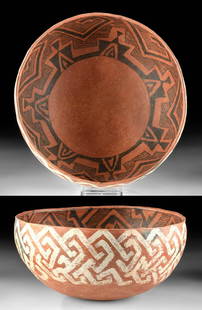
Sold2021Published Native American St. John's Pottery BowlSouthwestern USA, east central Arizona/west southern New Mexico, Ancestral Puebloan (Anasazi), ca. 1175 to 1300 CE. A splendid vessel of hemispherical form and vibrant coloring, created using the coilSee Sold Price
Featured3 days LeftJasper52South America. New Granada & Venezuela. Colombia Panama. SWANSTON 1860 old map$50
Featured3 days LeftJasper52Venezuela, New Granada & Ecuador by J.W. Lowry. Colombia 1860 old antique map$40
3 days LeftJasper52AMAZONIA.Showing "El Dorado?", missions & tribes. Brazil Ecuador.SDUK 1844 map$130
3 days LeftJasper52S AMERICA NW. Venezuela, New Granada(Colombia) w/Panama Ecuador.BLACKIE 1882 map$10
Featured3 days LeftJasper52Johnson's Venezuela, New Granada, Ecuador, Peru, Bolivia, Chile, Guiana 1861 map$85
Featured3 days LeftJasper52Andean States. Venezuela New Granada Ecuador Peru Colombia. SIDNEY HALL 1854 map$25
3 days LeftJasper52AMAZONIA showing "El Dorado?" & Missions. Brazil Ecuador Colombia SDUK 1874 map$120
Featured3 days LeftJasper52SOUTHERN MEXICO & CENTRAL AMERICA. Yucatan Belize Mosquito Coast.SDUK 1844 map$35
3 days LeftJasper52SOUTHERN MEXICO & CENTRAL AMERICA. Yucatan Belize Mosquito Coast. SDUK 1846 map$25
Featured3 days LeftJasper52South America. Bolivia with Litoral. New Granada. Banda Oriental. HALL 1854 map$35
3 days LeftJasper52La partie méridionale du Brésil et du Perou. SANTINI/D'ANVILLE 1784 old map$80
Featured3 days LeftJasper52Americae Australis / Peruana by Bertius / Langenes. South America 1603 old map$280


![Mitchell Map of Western U.S.: *** START PRICE IS THE RESERVE *** [America] MITCHELL, Samuel Augustus (1792-1868). A New Map of Texas, Oregon and California with the Regions Adjoining. Engraving with original hand color, with origi](https://p1.liveauctioneers.com/1968/163248/82424595_1_x.jpg?height=310&quality=70&version=1583340284)