Sold2022KENT – LYDD – MANUSCRIPT ESTATE MAP 'A Map of a Farm lying in the Parish of Lydd in ...KENT – MANUSCRIPT ESTATE PLAN 'A Map of a Farm lying in the Parish of Lydd in the County of Kent Belonging to the Reverd. Mr Richard Monins 1774.', manuscript map by Henry Maxted & Isaac Terry,See Sold Price
Sold2019Rockland county, NY Ariel maps Real Estate map rareRockland county, NY Ariel maps Real Estate map rareSee Sold Price
Sold20231810 Modern Geography America MAP + World Map Massachusetts Elijah Parish1810 Modern Geography America MAP + World Map Massachusetts Elijah Parish Elijah Parishs “New System of Modern Geography” is an early 19th-century American geography textbook. Published inSee Sold Price
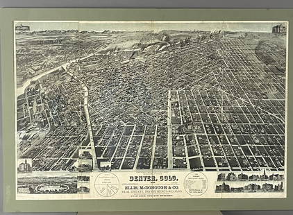
Sold2017Antique Real Estate Zone Map of Chicago, 1910Title/Content of Map: 1910 c. Real Estate Zone Map of Chicago -- Zone Map of Chicago Date Printed: 1910 c., Chicago Cartographer: Cook Co. Real estate Digest Size: 16.3 X 10.8 in. An interesting realSee Sold Price
Sold2022TWO 16TH TO 18TH CENTURY MAPSA lot of two sixteenth to eighteenth century maps. To include: "A Map of the Parish of St. Giles's" Sheet: 14" x 16.75" "Londinum Feracissimi", engravings on laid paper Sheet: 14.75" x 21"See Sold Price
Sold2024Early Map of North AmericaMap of North America Hand Colored Map. Map showing the Mexico when it contained California and Texas, as well as the United States claim on the west coast stretching to meet the Russian Possessions ofSee Sold Price
2023The Delaware River and Outdoor RecreationThe Delaware and Outdoor Recreation 10 Maps Maps show:State Parks, forests and game landsRiver access and recreation areasWhere to fish, swim and boatRapids, poolSee Sold Price
Sold2015(2pc) [INSURANCE MAPS OF GREENWICH, CONN.]published by Sanborn Map Company, 1920; plus a Greenwich real estate map, 25 3/4 x 23 1/2"See Sold Price
Sold2021Kent Estate Map, Chevening.- Barham (surveyor) The HomeKent Estate Map, Chevening.- Barham (surveyor) The Home Farm In Chevening Kent Belonging to The Ri.t Hon.ble Lord Amherst, manuscript watercolour estate map on vellum, fold, 475 x 500mm., 1797; and anSee Sold Price
Sold2022Real estate map for south part of San Francisco 1868Heading: -1868 Author: Kower, Emile Title: Map of the Golden Gate Homestead Association Place Published: San Francisco Publisher:Britton & Rey's Lithographic Steam Press Date Published: 1868<See Sold Price
Sold2020Real estate map of Berkeley Woods with ms. noted, 1917Heading: (California - Contra Costa County) Author: Title: Map of Berkeley Woods Contra Costa County, Cal. Scale 1 in. = 100 feet Place Published: [Berkeley, CA] Publisher: Date Published:See Sold Price
Sold2022France.- Manuscript estate maps.- Marche (Lecoy de la) [Survey of the estates of Château-France.- Manuscript estate maps.- Marche (Lecoy de la) [Survey of the estates of Château-Renault], manuscript, double-page preface and 2 tables, 9 double-page hand-coloured maps (numbered 2-10, aSee Sold Price
Sold2020Pocket real estate map of Bellingham WA 1910Heading: (Washington - Bellingham) Author: Title: Map of Bellingham north, Washington Place Published: Bellingham, Wash. Publisher:Bellingham Bay Improvement Co Date Published: 1910 DeSee Sold Price
Sold2022Sutro Heights real estate map c.1895Heading: -1895 Author: Title: Map of Sutro Heights. Lots for Sale by Will E. Fisher & Co., Agents Place Published: San Francisco Publisher: Date Published: c.1895 Description: LSee Sold Price
Sold20212 Early Estate Maps2 early estate maps. Hand colored all over with frame. 17" wide, 23" tall.See Sold Price
Sold2024Gano Estate Map, Spring Grove, Avondale & Cincinnati RailwayAmerica, 19th century. A map and letter dating to 1881 on the topic of the Gano Estate pertaining to the Spring Grove, Avondale & Cincinnati Railway. 428See Sold Price
Sold2018Decoupage C1880-1940 Set of 4. Natural History on MapsRecently Made Decoupage containing items published C1880-1940. Cut images laid onto Somerset Maps. Size: 11 x 8.5 inch (28 x 22cm) A little soiling. Good conditionSee Sold Price
Sold2018Map of San Francisco and Bay Counties With DetailedTitle/Content of Map: Map of San Francisco and Bay Counties With Detailed Information of Value Date: 1915 Cartographer: BALDWIN & HOWELL (REAL ESTATE AGENTS) Size: 12.5X16 Folding map on sheet 22"x17"See Sold Price
Sold2023ANTIQUE FLORIDA FRAMED MAPS - LOT OF 2148268 ANTIQUE FLORIDA FRAMED MAPS - LOT OF 2 Antique Florida map framed map to include one 1853 U.S. Coast Survey Chart or Map of St. George's Sound, Florida, and one unsigned map of Florida denotedSee Sold Price
Sold2021Vintage Richfield Highway Maps in CaseFour maps are included in this lot with original Richfield Map Case. Maps for California, Alaska, Oregon and Washington.See Sold Price
Sold2018Maps and Map MakersMaps and Map Makers Key reference work Author: Ronald Vere Tooley Illustrations Color B/W Illustrations Size: 4to Binding HarSee Sold Price
Sold2023Vintage Washington State Maps Topography MapsVintage Washington State Maps Topography Maps This is a set of 5 Washington State Topography Maps that show Surveys from the early 1900s. These are vintage reprints of the initial surveys done. TheseSee Sold Price
Sold2022Reproduction of 18th Century North America MapReproduction of 18th Century North America Map This map is a 20th century hand-colored lithographic reproduction of a 17th century map of the colonial territories held by Spain, England, and France. TSee Sold Price


![(2pc) [INSURANCE MAPS OF GREENWICH, CONN.]: published by Sanborn Map Company, 1920; plus a Greenwich real estate map, 25 3/4 x 23 1/2"](https://p1.liveauctioneers.com/522/81470/42273580_1_x.jpg?height=310&quality=70&version=1446235682)


![Real estate map of Berkeley Woods with ms. noted, 1917: Heading: (California - Contra Costa County) Author: Title: Map of Berkeley Woods Contra Costa County, Cal. Scale 1 in. = 100 feet Place Published: [Berkeley, CA] Publisher: Date Published:](https://p1.liveauctioneers.com/642/174090/87617742_1_x.jpg?height=310&quality=70&version=1595023143)
![France.- Manuscript estate maps.- Marche (Lecoy de la) [Survey of the estates of Château-: France.- Manuscript estate maps.- Marche (Lecoy de la) [Survey of the estates of Château-Renault], manuscript, double-page preface and 2 tables, 9 double-page hand-coloured maps (numbered 2-10, a](https://p1.liveauctioneers.com/5458/260724/135800184_1_x.jpg?height=310&quality=70&version=1662479034)