Sold2022Sketch G Showing the Progress in Section No. 7 ...Title: Sketch G Showing the Progress in Section No. 7 ... Date: 1850 Cartographer: U.S. COAST SURVEY Publisher: U.S. COAST SURVEY Description: in the year 1849 reconnoissance of Pensacola and PerdidoSee Sold Price
Sold2022Sketch I Showing the Progress of the Survey in Section No.9 [Texas Gulf Coast]Publication Date: 1853 Title: Sketch I Showing the Progress of the Survey in Section No.9 [Texas Gulf Coast] Cartographer: ANONYMOUS Publisher: U.S. COAST SURVEY Height: 17.5 Width: 21.6 TriangulationSee Sold Price
Sold2024Sketch I Showing the Progress of the Survey in Section No.9 1848 to 53Publication Date: 1853 Title: Sketch I Showing the Progress of the Survey in Section No.9 1848 to 53 Cartographer: U.S. COAST SURVEY Publisher: U.S. COAST SURVEY Height: 7.3 Width: 21.6 The year afterSee Sold Price
Sold2021Sketch I Showing the Progress in Section No.Ix fromTitle: Sketch I Showing the Progress in Section No.Ix from 1848 to 1866 [Vicinity of Galveston] Cartographer: U.S. COAST SURVEY Publisher: GPO Size: 10 X 25 Shows triangulation of Galveston Bay. A litSee Sold Price
Sold2020Sketch C Showing the Progress of Section No.III fromPublication Date: 1861 Title: Sketch C Showing the Progress of Section No.III from 1843 to 1860 Cartographer: U.S. COAST SURVEY Publisher: GPO Height: 34.25 Width: 22.75 Triangulation of Chesapeake BaSee Sold Price
Sold2018Chart of Outer Banks, 1853 U. S. Coast SurveyReserve Reduced! Hand-colored chart of the Outer Banks on the east coast of North Carolina and Virginia. “Sketch D Showing the Progress of Section IV, 1845-1853.” Area shown includes Albemarle SouSee Sold Price
Sold2018U.S. Coast Survey 1853 Map of Long Island, New Jersey"Sketch B Showing the progress of Section No. 2" Electrotype Map Published 1843-65, Washington for "Report of the Superintendent of the U.S. Coast Survey..." Published under the supervision and directSee Sold Price
Sold2023Sketch F showing the progress of the survey in Section No. VI from Cape Florida to Tortugas IslandsTitle: Sketch F showing the progress of the survey in Section No. VI from Cape Florida to Tortugas Islands from 1845 to 1861 Cartographer: Publisher: U.S. Coast Survey Height: 19.8 Width: 34 ExceptionSee Sold Price
Sold2021Sketch F. Showing the Progress of the Survey in SectionPublication Date: 1856 Title: Sketch F. Showing the Progress of the Survey in Section VI With a General Reconnoissance of The Coast Of Florida 1848-56 Cartographer: BACHE, A.D. Publisher: U.S. COAST SSee Sold Price
Sold2017Hand-Colored Lithograph Map of the Gulf of MexicoImpressive Hand-Colored Lithograph Map of the Gulf of Mexico, titled "U.S. Coast Survey, A.D. Bache Superintendent, Sketch H, Showing the Progress of the Survey in Section No. 8, 1846-1854", the map iSee Sold Price
Sold2017Florida Lithograph MapU.S. Coast Survey Sketch F Showing the Progress of the Survey in Section V. A.D. Bache (1806-1867). Lithographed map. Washington, D.C., 1855. 23 x 16 1/2 inches visible, 27 1/4 x 21 1/2 inches framedSee Sold Price
Sold2018U.S Coast Survey 1857 Map. New Orleans, Louisiana"Sketch II Showing The Progress of the Survey in Section No. VIII" A Rare Map centred on New Orleans and Lake Pontchartrain. Also showing Bon Secours Bay (Alabama) Isle au Breton Sound and Vermilion BSee Sold Price
Sold2020A.D. Bache U.S. Coast Survey Charts East Coast“A bis” A.D. Bache: Sketch A, Showing the progress of the Survey in SECTION No. 1, From 1844 to 1859. Scale 400,000. 1859. Measures 38” high X 25” wide. Paper size 37 3/4" x 25See Sold Price
Sold2018U.S Coast Survey 1856 Map. New Orleans, Louisiana"Sketch II Showing The Progress of the Survey in Section No. VIII" A Rare Map centred on New Orleans and Lake Pontchartrain. Also showing Bon Secours Bay (Alabama) Isle au Breton Sound and Vermilion BSee Sold Price
Sold2019U S Coast Survey 1896 Large Map. Portland Canal, Alaska"Progress Sketch Showing Triangulation of Portland Canal and Vicinity. S. E. Alaska" Large Lithograph Map Published 1896, Washington for "U.S. Coast and Geodetic Survey" Folds as issued. Rare. Paper SSee Sold Price
Sold2019U S Coast Survey 1896 LG Map. Gulf Coast. Florida, MI"Sketch Showing Progress of Surveys on the Gulf Coast Lake Pontchartrain Mobile and Pensacola Bays" Detailed map showing New Orleans to Santa Rosa Sound, with inset showing Tortugas Harbor. Large LithSee Sold Price
Sold2023Sketch Showing the Progress of the Survey On The Atlantic, Gulf of Mexico and Pacific Coast Of ThePublication Date: 1870 Title: Sketch Showing the Progress of the Survey On The Atlantic, Gulf of Mexico and Pacific Coast Of The United States to November 1870 Cartographer: PIERCE, BENJAMIN PublisherSee Sold Price
Sold2022Sketch Showing the Triangulation & Geographical Positions in Section No.Ii from New York City toPublication Date: 1881 Title: Sketch Showing the Triangulation & Geographical Positions in Section No.Ii from New York City to Point Judith ... 1879 Cartographer: U.S. COAST AND GEODETIC SURVEY SURVEYSee Sold Price
Sold2018U.S. Coast Survey 1853 Map of Cape Cod, MA, NH"Sketch A Shewing the progress of the Survey in Section No. 1" Electrotype Map Published 1843-65, Washington for "Report of the Superintendent of the U.S. Coast Survey..." Published under the supervisSee Sold Price
Sold2020Progress Sketch Sec. VI West Coast of Florida Tampa BayTitle/Content of Map: Progress Sketch Sec. VI West Coast of Florida Tampa Bay and Vicinity ... 1879 Publication Date: 1881 Cartographer: U.S. COAST AND GEODETIC SURVEY Publisher: GPO Description: ShowSee Sold Price
Sold2021Sketch B. Illustrating the Progress of the Survey ofTitle: Sketch B. Illustrating the Progress of the Survey of The Coast in Delaware and Chesapeake Bays and Vicinity in 1845. Cartographer: U.S. COAST SURVEY Publisher: U.S. C. S. Size: 9 X 13.5 TrianguSee Sold Price
Sold2019U S Coast Survey 1896 LG Map. West USA California Texas"Sketch of General Progress June 30. 1896." Showing Central and Western US, with part of Mexico. From Mississippi/Wisconsin through to West Coast. Large Lithograph Map Published 1896, Washington for "See Sold Price
Sold2019U S Coast Survey 1896 LG Map. New Orleans Texas Florida"Sketch of General Progress June 30. 1896" Showing Southern, Eastern and Mid West States, incl Florida, Texas, Gulf of Mexico, Georgia etc. Large Lithograph Map Published 1896, Washington for "U.S. CoSee Sold Price
Sold2023Sketch B. No.1. Illustrating the Progress of the Survey of The Coast in 1845, Showing The PositionsPublication Date: 1848 Title: Sketch B. No.1. Illustrating the Progress of the Survey of The Coast in 1845, Showing The Positions Occupied in Making Observations Upon Currents In Fisher's Island SoundSee Sold Price
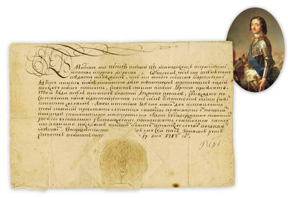
Jun 26University ArchivesPeter the Great 1717 DS Recruiting German Craftsmen, Notably Shipbuilders, Fascinating and Stunning!$4,000
7 hrs LeftTrillium Antique Prints & Rare BooksBuffon's Histoire Naturelle, Quadruped Section - 13 Volumes with 442 Engravings (221 in color, 221$500
4 days LeftDan Morphy AuctionsPLATE CXIII. MAP OF INDIAN TERRITORY SHOWING DISTRIBUTION OF WOODLAND” FROM THE TWENTY-FIRST$100
Jun 18DOYLE Auctioneers & AppraisersA gentleman's hand-held mechanical scoring device for billiards$425(4 bids)


![Sketch I Showing the Progress of the Survey in Section No.9 [Texas Gulf Coast]: Publication Date: 1853 Title: Sketch I Showing the Progress of the Survey in Section No.9 [Texas Gulf Coast] Cartographer: ANONYMOUS Publisher: U.S. COAST SURVEY Height: 17.5 Width: 21.6 Triangulation](https://p1.liveauctioneers.com/5584/270923/141842822_1_x.jpg?height=310&quality=70&version=1670433092)

![Sketch I Showing the Progress in Section No.Ix from: Title: Sketch I Showing the Progress in Section No.Ix from 1848 to 1866 [Vicinity of Galveston] Cartographer: U.S. COAST SURVEY Publisher: GPO Size: 10 X 25 Shows triangulation of Galveston Bay. A lit](https://p1.liveauctioneers.com/5584/192977/97277009_1_x.jpg?height=310&quality=70&version=1612304273)


![[First Australian novelist] Grimstone, Mary Leman (1 of 1)](https://p1.liveauctioneers.com/94/330664/178342107_1_x.jpg?height=282&quality=70&version=1716466933)