Sold2017An extremely attractive map of France and Belgium fromTabula tertia de Europa. Francesco Berlinghieri (1440-1501) attributed to Francesco Roselli (1445-before 1513). from Geographia. Engraved map. Florence: N. Laurentii, Alamanus, before 1482-early sixteSee Sold Price
Sold2022Dudley Sea Chart of DenmarkDUDLEY, Sir Robert (1574-1649). [Denmark] Carta particolare che comincia con il gran fiume Albis e contene parte dell mare Baltico e Ientrata al sondo di Danemarca... Engraved map. Florence, 1646.20 7See Sold Price
Sold2022Dudley Sea Chart of ArgentinaDUDLEY, Sir Robert (1574-1649). [Argentina] Carta particolare della costa di America Australe che comincia al C. di Matas sin al C. di Galegos. Engraved map. Florence, 1646. 20 7/8" x 16 1/8" sheet. SSee Sold Price
Sold2022Dudley Sea Chart of PortugalDUDLEY, Sir Robert (1574-1649). [Portugal] Carta Particolare Del Oceano Che Comincia Con il Capo S. Vincentio E Finisco Con Il Capo Roxo in PortogalloEngraved map. Florence, 1646. 20 7/8" x 17" sheet.See Sold Price
Sold2022Dudley Sea Chart of Western FranceDUDLEY, Sir Robert (1574-1649). [France] Carta particolare della costa di Guasconnia in Francia che comincia con il Fiuime di Burdeaux e Finisce con l'Isola di Heys. Engraved map. Florence, 1646. 20 7See Sold Price
Sold2018SDUK: Antique Map of Florence, Italy, 1835Title/Content of Map: Florence Cartographer: Baldwin & Cradock / SDUK Place & Date: London / 1835 Size: 14 7/8" x 11 1/8" Condition: river, forts, walls and gardens colored; light overall age toningSee Sold Price
Sold20231872 Pianta Della Citta Di Firenze (City of Florence) Map LithographDESCRIPTION: Pianta Della Citta Di Firenze (Plan of the City of Florence) Map of Florence Italy. Each segment backed by canvas. Map marked: "E.E. Oblieghi e V. Romanelli editori proprietari" (Lower MiSee Sold Price
Sold2017SDUK, Map of Florence, 1835Map: Florence Maker: Society for the Diffusion of Useful Knowledge (SDUK) Date: 1835 Size: 11 x 14.75 inches A wonderfully detailed plan of Florence with original hand coloring. Many place names and nSee Sold Price
Sold2020Large Contemporary Florence Map Print TapestryLarge Contemporary Florence Map Print Tapestry. Map of Florence printed on canvas with wood pediment and rod. Measures approximately 74 inches x 100 inches.See Sold Price
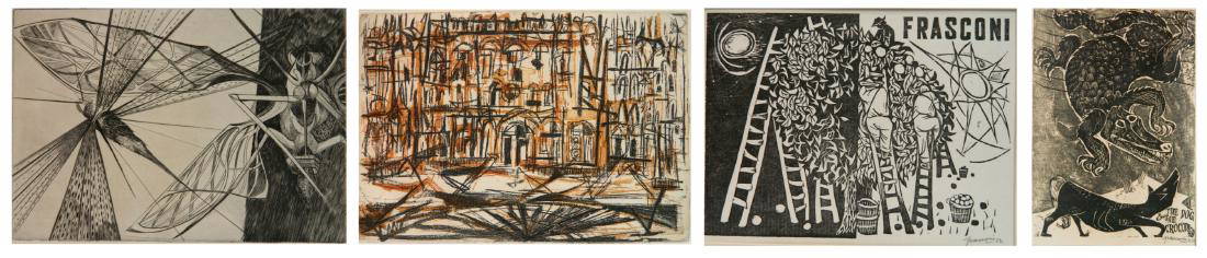
Sold20184 Print Club of Cleveland prints4 Print Club of Cleveland prints- 1.) and 2.) Antonio Frasconi- Dog and Crocodile; Day and Night- 2 woodcuts; 3.) Rudy Pozzatti- ''Palazzo Florence''- etching; and 4.) Walter Rogalski- ''Locust''- etcSee Sold Price
Sold20231835 of Florence -- Florence, FirenzeTitle: 1835 of Florence -- Florence, Firenze Cartographer: SDUK Year / Place: 1835, London Map Dimension (in.): 11 X 14.8 in. This is an excellent map of Florence, Italy. Four bridges are shown to croSee Sold Price
Sold2017Lot of Pop-Out City Maps, otherComprises pop-out maps of Florence, Rome, Seattle and more, and folding maps of London, Paris, others.See Sold Price
Sold2021Hand Drawn Map of Firenze (Florence)Appears to be a 20th century hand drawn copy of an 18th century map, well done, 17" x 22 1/4" sight, 26 1/4" x 32 1/4" framed.See Sold Price
Sold2017Florence, old MapLa Citta de Firenze Capitale del Gran Ducato di Toscana, Florence Signature: Unsigned. Medium: Etching. Framing: Unframed. Artist: unknown. Size: 6.25 x 14.25""All condition information is available bSee Sold Price
Sold2021Antique Map of Tuscany (Florence), ItalyAntique Map of Tuscany (Florence), Italy. Dominio Fiorentino-Blaeu-1646(after). Antique hand colored map of Tuscany; 15.5in. X 19.5in.(image size)See Sold Price
Sold2017Mattheus Seutter, Antique Map of Firenza, c.1730Antique map of Firenza / Florence, Italy by Mattheus Seutter, Augsburg c.1730. Copperplate engraving, the image measures 18-7/8" x 22". Sheet measurement 20-3/8" x 25". Elaborate cartouche of the citySee Sold Price
Sold2018Florence C1920 Large Folding Map. Italy"Carta dei Dintorni di Firenze" Lithograph Map Published C1920, Florence by the Societa Editrice Fiorentina. Illustrated boards. Descriptive Italian Text on verso. Paper Size: 27.5 x 19.5 inch (70 x 4See Sold Price
Sold2020Rudy Pozzatti etching and engravingRudy Pozzatti (American 1925- )- ''Palazzo, Florence''- etching and engraving in colors, 1955, signed and dated in pencil, edition of 250, The Print Club of Cleveland publication no. 33, very good conSee Sold Price
Sold2017Rudy O. Pozzatti intaglioRudy O. Pozzatti (American 1925- )- ''Palazzo, Florence''- etching, engraving, aquatint, soft ground and lift ground in colors, 1954, signed in pencil, edition of 250 plus 10, The Print Club of ClevelSee Sold Price
Sold2023Rudy Pozzatti (American, 1925-2021)Rudy Pozzatti (American, 1925-2021) Palazzo, Florence, Etching and engraving in colors, Signed and dated in pencil lower right. The Print Club of Cleveland Publication No. 33 for 1955. Edition of 250.See Sold Price
Sold20211902 Medieval Towns Ancient Florence Italy1902 Medieval Towns Ancient Florence Italy Constantinople Ferrara MAPS 4v Hutton William Holden Hutton’s “Medieval Towns” is an early 20th-century set of histories on iconic ancient towns includSee Sold Price
Sold2022A map and view of town of Florence, 18th century.1)A map and view of the town of Florence, 18th century, unknown maker - some discoloration around mat and border, and 2 small burn marks (?) near center, otherwise very good condition - see photos forSee Sold Price
Sold2017Stackhouse: Antique Map of Northern Italian States 1783Title/Content of Map: Northern Italian states Venice, Milan, Florence, Genoa with Switzerland Date Printed: 1783 Cartographer: Thomas Stackhouse Material/Medium: Paper Size: 16" x 20" Original hand coSee Sold Price
Sold201717 vintage travel maps/brochures/pamphlets17 vintage travel maps/brochures/pamphlets including Florida Silver Springs; Map of principle events George Washington; Germany; Rome to Florence; Howe Caverns; Sunoco Florida road map; Standard oil SSee Sold Price
Jun 29JM Hobby Supply and Railroad Artifact AuctionsFlorence & Cripple Creek RR Public Timetable-September 1894$400
Jun 07Freeman's | HindmanWOOLWARD, Florence. The Genus Masdevallia... 1890-1896. FIRST EDITION.$1,200
1 day LeftAlbion AuctionsMarmocchi, F. C. 1845 Hand Col Map. Judaica - Jewish World & Israelites Camp$5
1 day LeftAlbion AuctionsMarmocchi, F. C. 1845 Hand Col Map. Holy Land. Persia Empire, Alexander the Great$5
1 day LeftAlbion AuctionsMarmocchi, F. C. 1845 Hand Col Map. Black Sea. Greece Armenia Turkey Russia$5
May 30Forum AuctionsItaly.- Zuccagni-Orlandini (Attillio) Atlante Geografico degli stati Italiani...[&] Atlante£1,500


![Dudley Sea Chart of Denmark: DUDLEY, Sir Robert (1574-1649). [Denmark] Carta particolare che comincia con il gran fiume Albis e contene parte dell mare Baltico e Ientrata al sondo di Danemarca... Engraved map. Florence, 1646.20 7](https://p1.liveauctioneers.com/1968/250616/130196505_1_x.jpg?height=310&quality=70&version=1654190895)
![Dudley Sea Chart of Argentina: DUDLEY, Sir Robert (1574-1649). [Argentina] Carta particolare della costa di America Australe che comincia al C. di Matas sin al C. di Galegos. Engraved map. Florence, 1646. 20 7/8" x 16 1/8" sheet. S](https://p1.liveauctioneers.com/1968/250616/130196501_1_x.jpg?height=310&quality=70&version=1654190895)
![Dudley Sea Chart of Portugal: DUDLEY, Sir Robert (1574-1649). [Portugal] Carta Particolare Del Oceano Che Comincia Con il Capo S. Vincentio E Finisco Con Il Capo Roxo in PortogalloEngraved map. Florence, 1646. 20 7/8" x 17" sheet.](https://p1.liveauctioneers.com/1968/250616/130196507_1_x.jpg?height=310&quality=70&version=1654190895)
![Dudley Sea Chart of Western France: DUDLEY, Sir Robert (1574-1649). [France] Carta particolare della costa di Guasconnia in Francia che comincia con il Fiuime di Burdeaux e Finisce con l'Isola di Heys. Engraved map. Florence, 1646. 20 7](https://p1.liveauctioneers.com/1968/250616/130196506_1_x.jpg?height=310&quality=70&version=1654190895)


![Italy.- Zuccagni-Orlandini (Attillio) Atlante Geografico degli stati Italiani...[&] Atlante (1 of 4)](https://p1.liveauctioneers.com/5458/329231/177514980_1_x.jpg?height=282&quality=70&version=1715269091)


