Sold2016Large plan of Paris 1814Heading: Author: Bonnisel, J. Title: Plan de la Ville et Faubourgs de Paris avec ses Monuments… Place Published: Paris Publisher: Date Published: 1814 Description: EngravedSee Sold Price
Sold2023Esnauts (Jacques) Nouveau Plan Routier de la Ville et Faubourgs de Paris Avec ses Principaux EdificeEsnauts (Jacques) and Michel Rapilly. Nouveau Plan Routier de la Ville et Faubourgs de Paris Avec ses Principaux Edifices Par M. Pichon, large wall map of Paris, the border decorated with 28 vignettesSee Sold Price
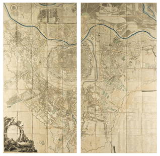
Sold2016Planning.- Haussmann (Georges Eugène) Plan GeneralPlanning.- Haussmann (Georges Eugène, Baron) Plan General de la Ville de Paris et de ses Environs comprenant les Bois de Boulogne et de Vincennes..., title comprising large mounted photograph ofSee Sold Price
Sold2016Plan of Paris 1803Heading: Author: Jean, Pierre Title: Plan Routier de la Ville et Faubourg de Paris, divisé en 12 municipalités Place Published: Paris Publisher:Chez Jean Date Published: 1803, An 11 DeSee Sold Price
Sold2023MAP: Robert de Vaugondy "Plan de la Ville et des Faubourgs de Paris" map of Paris circa late 1700's,MAP: Robert de Vaugondy "Plan de la Ville et des Faubourgs de Paris" map of Paris circa late 1700's, folded into paper holder, 22 1/2" x 33"See Sold Price
Sold2018Bellin: Antique Map of Early Boston, 1757Title/Content of Map: Plan de la Ville de Boston et ses Environs Cartographer: Bellin Place & Date: Paris / 1757/1760 Size: 10 5/8" x 6 3/8" Condition: b&w; light overall age toning; a few spots in thSee Sold Price
Sold20241812 large French map of Paris plan routier de la Ville et faubourgLarge engraving of Paris and its surrounding area dated 1812 , cooper engraving in the manner of the Turgot map ,Jean Pierre printer , a Paris, chez Jean, Rue St Jean de Beauvais, N° 10, It is thSee Sold Price
Sold2018Austria.- Grimm (Maximilian von) Grundriss der Kl: Kl:Austria.- Grimm (Maximilian von) Grundriss der Kl: Kl: Haupt und Residenzstadt Wien mit ihren Vorstadten nach den Neuen Hausnumern 1797 / Plan de la Ville de Vienne et de ses Fouxbourgs avec le DenombSee Sold Price
Sold2020Georges Louis Rouge Plan of Paris Map 1765Georges-Louis Le Rouge (ca. 1712-1780), "Plan de Paris et de ses faubourgs en l'état qu'il étoit en 1765." This attractive map features the city of Paris along with points of interest. DimensionSee Sold Price
Sold2016c. 1770 Georgeous Hand-Colored Plan of BostonColonial America Hand-Colored Plan of Boston Town and Harbor by Bellin c. 1770 Colonial Era, “Plan de la Ville de Boston et Ses Environs,” Jacques Nicolas Bellin, Choice Crisp Extremely Fine. ThisSee Sold Price
Sold2023Plan de la Ville et Fauxbourgs de ParisPlan de la Ville et Fauxbourgs de Paris, 1763 historic wall map of Paris, 1777 "Divise en 20 quartiers dont la plus grande partie a ete rectifiee" by Debarme paper size 60" x 70 1/2", frame size 62" xSee Sold Price
Sold2023Delisle Map of Paris, France, Hand Colored 1716Important Map of Paris by Guillaume De L'Isle, Full Title: Plan de la Ville et Fauxbourgs de Paris. Dressee sur les observations astronomiques de l'Academie Royale des Sciences et sur les operations gSee Sold Price
Sold2021[MAPS] SÉBASTIEN DE PONTAULT, CHEVALIER DE[MAPS] SÉBASTIEN DE PONTAULT, CHEVALIER DE BEAULIEU. Plan de la Ville, et Chateau de Valence... Paris: circa 1690. 17 1/2 x 21 inches, hand-colored engraving. Usual folds, generally a clean exampSee Sold Price
Sold2020[MILITARY ARCHITECTURE] 9 plans together[Fortifications and Military Architecture.] A collection of nine maps sold together including Fer, Nicolas de. PLAN DE LA VILLE OUVRAGES ET CHTEAU DE NAMUR. Paris, [c. 1692] 36 x 51.5 cm. **And eightSee Sold Price
Sold2022DEL RIO, JOSE Plan du Port et de la Ville de la Havanne leve en 1798. [Paris:] par Ordre du MinistreDEL RIO, JOSE Plan du Port et de la Ville de la Havanne leve en 1798. [Paris:] par Ordre du Ministre de la Marine et des Colonies, l'An IX de l'Ere Francaise, [circa 1800]. Engraved map with the "DepoSee Sold Price
Sold2022New road map of the city of Paris 1839 Rosselin editeur engravingNouveau plan routier de la ville de Paris, Guide exacte de cette capitale : en 12 arrondissemens avec leurs mairies et en 48 quartiers, 1839V. ROSSELIN (19th century), print editor, Paris, EstablishedSee Sold Price
Sold2017Bellin: Antique Map Plan of Portobello, Panama, 1756Map: Plan de la Baye et Ville de Portobelo en 1736 Cartographer: Bellin Place & Date: Paris / 1756 Size: 12 7/8" x 7 5/8" Condition: b&w; overall age toning; with folds as issued Bellin's detailed chaSee Sold Price
Sold2018Haussard: Bay and Town of Portobelo, PanamaMap: Plan de la Baye et Ville de Portobelo en 1736 Cartograper: Haussard Place / Date: Paris / 1750s Size: 8 7/8" x 4 7/8" Condition: b&w. light overall age toning and a few minor spots and folds as iSee Sold Price
Sold2017Bellin: Plan of Malacca City/Tonkin River Basin ChartMap: Plan de la Ville et Forteresse de Malaca [and on the same sheet] Carte du Cours de la Riviere de Tunquin [Tonkin] Depuis Cacho jusqu'a la Mer Cartographer: Bellin Place & Date: Paris / 1750/1760See Sold Price
Sold20211748 Plan Isle of Macau ChinaCirca 1748 Plan De La Ville Et Du port De Macao by Jacques Bellin. Printed at Paris. Fine condition, measures 7.5 x 10". Reserve: $80.00 Shipping: Domestic: Flat-rate of $6.00 to anywhere within the cSee Sold Price
Sold2022SARTINE, ANTOINE DE Carte d'une partie des côtes de la Floride et de la Louisiane, contenant leSARTINE, ANTOINE DE Carte d'une partie des côtes de la Floride et de la Louisiane, contenant le cours du Mississipi, depuis ses... [Paris: Dépôt des Cartes et Plans de la Marine], 1778.See Sold Price
Sold2021J. Jerome, Rue Monge 38 Paris Map - 1880 - Backed onPAU ET SES ENVIRONS DEIDE AU 18 DE LIGNE ET A LA VILLE DE PAU 1880 J. Jerome, Rue Monge 38 Paris. Map backed on Linen. Has normal discoloration for age but is in excellent condition. Measures approx.See Sold Price
Sold2021Bellin, Jacques-Nicolas - Plan du port et ville deBellin, Jacques-Nicolas (1703-1772) Plan du port et ville de Louisbourg dans l'Isle royale (1744) Description: P.N.B. Ing. de la M. 1744. Extract from the Petit atlas maritime published in Paris in 17See Sold Price
Sold20231713 DESCRIPTION OF PARIS 3 volumes antique ILLUSTRATED w/ 28 FOLDING PLATESGermain Brice Description de la Ville de Paris et de Tout ce Qu'elle contient de plus remarquable... Paris: Francois Fournier, 1713 Illustrated with 28 folding copper plates. Size 4 by 6.5" Original fSee Sold Price
5 days LeftJasper52Carte du Lac de Genève et des pays circonvoisins'. Geneva plan. CHOPY 1740 map$550
5 days LeftSwann Auction Galleries(VUES d'OPTIQUE.) Group of 15 hand-colored engraved European vues.$300
4 days LeftJasper521804 TRAVELS of Ledyard & Lucas in Africa antique w/ MAPS Voyages de MM. Lédyard$240
BonhamsGRANDPRE (LOUIS DE) Voyage a la côte occidentale d'Afrique, fait dans les annees 1786 et 17...£500
Jun 16Maison Jules VeilinghuisOld panoramic view of the siege Oudenaarde by Frans Van der Meulen, copper engraving (Veuë de la€500
2 days LeftRapid Estate Liquidators and Auction Gallery1908 Souvenirs Et Campagnes Par R. De La Ville$55
5 days LeftJasper52Carte L’Asie. Asia. Mughal Empire. Oirat Kingdom. Tartary. VAUGONDY 1750 map$280


![[MAPS] SÉBASTIEN DE PONTAULT, CHEVALIER DE: [MAPS] SÉBASTIEN DE PONTAULT, CHEVALIER DE BEAULIEU. Plan de la Ville, et Chateau de Valence... Paris: circa 1690. 17 1/2 x 21 inches, hand-colored engraving. Usual folds, generally a clean examp](https://p1.liveauctioneers.com/292/204169/103522320_1_x.jpg?height=310&quality=70&version=1621026354)
![[MILITARY ARCHITECTURE] 9 plans together: [Fortifications and Military Architecture.] A collection of nine maps sold together including Fer, Nicolas de. PLAN DE LA VILLE OUVRAGES ET CHTEAU DE NAMUR. Paris, [c. 1692] 36 x 51.5 cm. **And eight](https://p1.liveauctioneers.com/1124/187577/94368877_1_x.jpg?height=310&quality=70&version=1607095126)
![DEL RIO, JOSE Plan du Port et de la Ville de la Havanne leve en 1798. [Paris:] par Ordre du Ministre: DEL RIO, JOSE Plan du Port et de la Ville de la Havanne leve en 1798. [Paris:] par Ordre du Ministre de la Marine et des Colonies, l'An IX de l'Ere Francaise, [circa 1800]. Engraved map with the "Depo](https://p1.liveauctioneers.com/292/250642/130213494_1_x.jpg?height=310&quality=70&version=1654271664)


![Bellin: Plan of Malacca City/Tonkin River Basin Chart: Map: Plan de la Ville et Forteresse de Malaca [and on the same sheet] Carte du Cours de la Riviere de Tunquin [Tonkin] Depuis Cacho jusqu'a la Mer Cartographer: Bellin Place & Date: Paris / 1750/1760](https://p1.liveauctioneers.com/5584/105261/53910605_1_x.jpg?height=310&quality=70&version=1497542970)

![SARTINE, ANTOINE DE Carte d'une partie des côtes de la Floride et de la Louisiane, contenant le: SARTINE, ANTOINE DE Carte d'une partie des côtes de la Floride et de la Louisiane, contenant le cours du Mississipi, depuis ses... [Paris: Dépôt des Cartes et Plans de la Marine], 1778.](https://p1.liveauctioneers.com/292/250642/130213716_1_x.jpg?height=310&quality=70&version=1654271664)


