Sold2017Map of Sicily Islands 1814Engraving, Map by John Pinkerton, 1814. Map features just islands but was part of a four panel map grid. Dimensions: 11 1/4" x 14 1/4" Please note that this lot has a confidential reserve. When you leSee Sold Price
Sold2023ASC Anderson: Asia MinorASC Anderson: Asia Minor Engraved map with hand-coloring, 1814; together with Giovanni Montecalerio: Confinia Prou Bonoiensis, engraved map with hand-coloring, c. 1715; and Mappa Fluxus et Refluxux raSee Sold Price
Sold2022Antique Map Print - India - AsiaSet of 4 Map Prints. Antique lithographic map originates from "Letts's Popular Atlas", being a series of maps delineating the whole surface of the globe, with many special and original features; and aSee Sold Price
Sold2022Antique Map Print - Russia in Asia - Syria - TurkestanSet of 4 Map Prints. Antique lithographic map originates from "Letts's Popular Atlas", being a series of maps delineating the whole surface of the globe, with many special and original features; and aSee Sold Price
Sold2023Atlas: “Mitchell’s New General Atlas,” Augustus Mitchell, 1864Hand-colored lithographic maps, original boards disbound, lacks maps of Louisiana, California, Utah, Asia, Denmark, Switzerland and Hindoostan, remaining maps with bright colors Sold as a collection oSee Sold Price
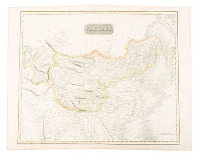
Sold2019Map of Tartary comprising most of AsiaHeading: (Maps) Author: Thomson, John Title: Tartary Place Published: Edinburgh Publisher: Date Published: 1814 Description: Engraved map, hand-colored in outline. 49.8x59.5See Sold Price
Sold20201813 Geography Atlas MAPS Benjamin Davies World Turkey1813 Geography Atlas MAPS Benjamin Davies World Turkey ASIA USA Ireland Davies’ “A new system of modern geography” was written as a middle ground between the verbose grammars of Pinkerton, GuthrSee Sold Price
Sold2017Carey: Map of Russian Empire in Europe & Asia, 1814Map: The Russian Empire, in Europe and Asia. Publication Date: 1814 Authors: M. CAREY, CAREY, MATHEW Publisher: M. CAREY Size: Folio – 11.30 H x 15.90 W Inches Korea shown as part of Chinese TartarySee Sold Price
Sold2022Map of State of Nations from unique 1814 Watson atlas“State of Nations at the Christian Era from Pinkerton on the Goths” scarce map from the unique Atlas of Ten Select Maps of Ancient Geography by John P. Watson. This is the only known editiSee Sold Price
Sold20231814 map of Mexico showing Provincia Texas, M. CareyExtremely scarce and desirable map of Mexico or “New Spain” from Mathew Carey’s rare 1816 General Atlas. One of the earliest maps of Mexico published in America. Shows “ProvinSee Sold Price
Sold2017Pinkerton: Map of the Southern United States, 1809Map: 1809 Pinkerton Map of the Southern United States Maker: J. Pinkerton Published: 1809 London Size: 20 x 27.5 in. plus matting. A different and unique perspective of the Southern US showing VirginiSee Sold Price
Sold20181814 Map of New Jersey -- The State of New Jersey,Title/Content of Map: 1814 Map of New Jersey -- The State of New Jersey, Compiled from the Most Authentic Information Date: 1814, Philadelphia Cartographer: M Carey Size: 18.5 x 13 in. A rather attracSee Sold Price
Sold2024Carey, pub. 1814 - Map of the State of TennesseeThis engraved map is from Mathew Carey's General Atlas, improved and enlarged: being a collection of maps of the world and quarters, their principal empires, kingdoms, &c. The work was published in PhSee Sold Price
Sold20201813 Pinkerton Map of the Arabian Peninsula and the RedTitle/Content of Map: 1813 Pinkerton Map of the Arabian Peninsula and the Red Sea -- Arabia Date: 1813, London Cartographer: J Pinkerton Size: 20 X 28 in. This is a stunning large format map of the ArSee Sold Price
Sold2022Very scarce 1814 Map of Virginia, Mathew CareyMathew Carey's map of Virginia, one of the best large format maps of the state to appear in a Commercial Atlas. From an extremely scarce 1816 edition of Carey’s General Atlas (the same map as inSee Sold Price
Sold2022LAPIE ORIGINAL ANTIQUE MAP ASIA MINOR 1831L' ASIE MINEURE 1831 SIZE: 25.5 X 20 INCHES APPROX. UNFRAMEDSee Sold Price
Sold2024Carey, pub. 1814 - Map of Mexico or New SpainThis engraved map is from Mathew Carey's General Atlas, improved and enlarged: being a collection of maps of the world and quarters, their principal empires, kingdoms, &c. The work was published in PhSee Sold Price
Sold20171809 Pinkerton Map of North East United States1809 Pinkerton Map of North East and Mid-Atlantic United States -- United States of America Northern Part J. Pinkerton 1809 London 20 x 27.5 in. plus matting. A detailed sharp map of the Mid-AtlanticSee Sold Price
Sold20161812 Pinkerton Map of Southern ItalyCirca 1812 map. Frame: 33.75" x 26" image sight: 28.5" x 20.75"See Sold Price
Sold2022[MAP-CUBA] Official Map of Cuba. Folding lithographic map of Cuba published in Trumbull White's[MAP-CUBA] Official Map of Cuba. Folding lithographic map of Cuba published in Trumbull White's Pictorial History of Our War With Spain, 1898. An inset features the city plan of Havana and text headedSee Sold Price
Sold2023MAP, Asia, PtolemySouthern Asia. Ptolemy/Ruscelli, Tabula Asiae IX, from Geographia Cl. Ptolemaei Alexadrini..., 1562 (circa). Black & White. This Ptolemaic map covers most of present-day Iran, Afghanistan, and PakistaSee Sold Price
Sold2023Lizars, Daniel 1831 LG Rare HC Map. Asia on 2 SheetsLarge Folio Copper Engraved Map Published 1831-2 by John Hamilton, Successor to Daniel Lizars, Edinburgh for "The Edinburgh Geographical and Historical Atlas..." First Edition by Daniel Lizars. Very fSee Sold Price
Sold2023Bowen, Thomas 1789 Large Map. Asia"A New & Accurate Map of Asia" Copper Engraved Map Published 1789-91 by C. Cooke, London for "The New Royal Encyclopedia, Or, Complete Modern Universal Dictionary of Arts and Sciences..." by William HSee Sold Price
Sold20221814 map of Romanum Imperium by Robt. WilkinsonVintage hand colored map from the unique Atlas of Ten Select Maps of Ancient Geography by John P. Watson. This is the only known edition of this atlas. The map is by Robert Wilkinson. A legend on theSee Sold Price
1 day LeftTrillium Antique Prints & Rare BooksCarey, pub. 1814 - Map of the East Indies with India, China, & New Holland (Australia)$50(1 bid)
1 day LeftTrillium Antique Prints & Rare BooksCarey, pub. 1814 - Map of New South Wales, Australia$50
6 days LeftJasper52Amér. Mér. Guyane Anglaise #4 bis. Guyana Suriname. VANDERMAELEN 1827 old map$30
6 days LeftJasper52Amér Sep Grandes Antilles 73 Jamaica Pedro Bank San Andrés VANDERMAELEN 1827 map$45
6 days LeftJasper52Amér. Sep. Curacao #74. Aruba Bonaire Puerto Rico Beata. VANDERMAELEN 1827 map$130
6 days LeftJasper52Amér Sep Porto Rico #69 Puerto Rico & Virgin Islands VANDERMAELEN 1827 old map$130
6 days LeftJasper52Amér. Sep. Ile de Cuba #67. Cuba & Jamaica Cayman Islands. VANDERMAELEN 1827 map$150
6 days LeftHunt and Peck Estate Services, Inc.1696 Jaillot Mapping The Ottoman Empire at the End of the 17th Century$140
1 day LeftTrillium Antique Prints & Rare BooksPtolemy & Magini, pub. 1620 - Map of the Ancient World with Africa, Europe, Asia$50
5 days LeftJasper521680 Jansson/Duval Map of Middle East -- Tabula Itineris Decies Mille Graecorum sub Cyro Contra$140(1 bid)
May 16Potter & Potter AuctionsPOLAND, Edwin Christian (1903 – 1991). The Evergreen Playgr...$200
6 days LeftHunt and Peck Estate Services, Inc.Abraham Ortelius Natoliae, Quae Olim Asia Minor, Nova Descriptio$100


![[MAP-CUBA] Official Map of Cuba. Folding lithographic map of Cuba published in Trumbull White's: [MAP-CUBA] Official Map of Cuba. Folding lithographic map of Cuba published in Trumbull White's Pictorial History of Our War With Spain, 1898. An inset features the city plan of Havana and text headed](https://p1.liveauctioneers.com/292/250642/130213661_1_x.jpg?height=310&quality=70&version=1654271664)


