Sold2023Pacific Islands. Polynesia Micronesia Melanesia. Fiji Caroline &c TIMES 1900 mapTITLE/CONTENT OF MAP: 'Polynesia' DATE PRINTED: 1900 IMAGE SIZE: Approx 26.0 x 39.5cm, 10.25 x 15.5 inches (Large) TYPE: Antique colour atlas map CONDITION: Good; suitable for framing. Please check thSee Sold Price
Sold2020Large Pacific Islands Tapa Cloth, ca. 1970**First Time At Auction** Pacific Islands, Fiji, Samoa, Hawaii, Tonga, the Cook Islands, or Papua New Guinea, ca. 1970 CE. A stunning tapa cloth presenting multiple bands of stylized geometric motifsSee Sold Price
Sold202370304: A Marshall Islands Navigation Map Micronesia, 1A Marshall Islands Navigation Map Micronesia, 19th century Constructed of coconut palm leaf midribs and shells. Such maps or charts were for navigating specific atolls and islands in MicrSee Sold Price
2024Huge / Fine 19th C. Hawaiian Kou Wood Meat Platter**First Time At Auction** North Pacific, Hawaiian Islands, ca. 19th century CE. A marvelous and massive meat serving platter of rectangular form with rounded shorter sides and a shallow bowl, intendedSee Sold Price
Sold202119th C. Hawaiian Volcanic Stone Fishing Sinker**First Time At Auction** North Pacific, Hawaiian Islands, ca. 18th to 19th century CE. A porous piece of volcanic stone carved into a fishing weight. The sinker has a shallow groove encircling the ceSee Sold Price
Sold2023Beautiful 19th C. Hawaiian Kou Wood Umeke (Bowl)**First Time At Auction** North Pacific, Hawaiian Islands, ca. 19th century CE. A beautiful and sizable serving vessel hand-carved from richly-grained kou wood known as an umeke (also umeke la'au pakaSee Sold Price
Sold2023Huge 19th C. Hawaiian Wood Feast Platter**First Time At Auction** **This item is heavy/oversized, and may require 3rd party shipping. Please inquire about shipping cost prior to bidding** North Pacific, Hawaiian Islands, ca. 19th century CESee Sold Price
Sold20211721 Map of America With California as an IslandHistoric Maps 1721 Hand-Colored "A New Map of America from the Latest Observations" with "California" Shown as an Island 1721 Hand-Colored Engraved Western Hemisphere Map titled, "A New Map of AmericaSee Sold Price
Sold2022Munson's A New Map of the Western Rivers, 1846MUNSON, Sam[ue]l B[ishop] (1806-1880). A New Map of the Western Rivers. Or Travellers Guide Exhibiting the Mississippi, Missouri, Ohio, and Illinois Rivers, with all the Principal Towns, Islands & DisSee Sold Price
Sold2023Wyland, "Island Time" Hand Signed Original Painting on Board with Certificate of Authenticity."Island Time" is an original painting on Board by Wyland that is hand signed and comes with a certificate of authenticity. The frame is imperfect with moderate wear. Measures approximately 46" x 32" (See Sold Price
Sold2023Wyland- Original Painting on Canvas "Island Time"Artist: Wyland. Medium: Original Painting on Canvas. Title: Island Time. Size: 24" x 36". Measures approx. 33" x 45" (framed). Signature: Hand Signed by the artist. Certificate of Authenticity: Is incSee Sold Price
Sold2023A Fiji Islands "Totokia" Pineapple ClubFijian Islands, incised bands of extensive decoration along the shaft depicting two crescent moons and one human form, curving to a spiked bulbous head at end, overall 39 in. Provenance: Christie's NeSee Sold Price
Sold2022Totokia - ClubFiji Islands Wood, 93,5 cm Provenance: Collected by Pierre Michel Alphonse Laurent (1769-1841) naval ensign on "La Topaze" or by his son Michel Albert Laurent (1815-1888) Jean-PaSee Sold Price
Sold2023Gorgeous 18th C. Hawaiian Kou Wood Bowl, Old RepairsNorth Pacific, Hawaiian Islands, ca. 18th century CE. A grandiose and gorgeous calabash bowl, skillfully hand-carved from wood of the kou tree - an inherently beautiful Hawaiian hardwood with a warm gSee Sold Price
Sold2021Large 18th C. Hawaiian Wood & Sennit Fishing HookNorth Pacific, Hawaiian Islands, ca. 18th century CE. A gorgeous wooden fishing hook used for shark or other larger fish with a curved profile and barb on the tip. At the top is a length of sennit (coSee Sold Price
Sold20211958-A Disneyland Souvenir Park Map.(Disneyland, 1958) A large souvenir map of Disneyland from 1958. This map was the first of three versions of the first-year, large format souvenir maps. This 1958-A map features subtle differences froSee Sold Price
Sold2020Mitchell Map of Western U.S.*** START PRICE IS THE RESERVE *** [America] MITCHELL, Samuel Augustus (1792-1868). A New Map of Texas, Oregon and California with the Regions Adjoining. Engraving with original hand color, with origiSee Sold Price
Sold202219th C. Caroline Islands Yap Limestone Rai CurrencyOceania, Micronesia, Caroline Islands, Yap region, ca. 19th century CE. This is a massive wheel shaped stone disc known as a "rai" (also a raay or dei) with a wide hole drilled through the center. TheSee Sold Price
Sold2023PETER DE SEVEPETER DE SEVE (American, b. 1958), Coney Island boardwalk scene [New Yorker cover illustration], published September 6, 1993, pen, ink and watercolor on paper, signed lower right. Hinge-mounted, matteSee Sold Price
Sold2022Colom's Map of the Western Indian Ocean, c. 1658COLOM, Arnold (1624-1668). Oost Indien van Cabo de Bona Esperanca tot Ceilon. Engraved map with original hand color in outline. Amsterdam, c. 1658. 22 1/4" x 25 1/2" sheet. Colom's Zee Atlas is amongSee Sold Price
Sold2022Jim Reno Large Western Bronze Sculpture Quttin Time In Texas Cowboy Horse SignedThis lot includes:Gallery COA & free domestic shipping (*insurance and international shipping for an additional charge)Artist: Jim Reno Title: Quittin Time In TexasMedium: BronzeSize: 23" x 14" x 14"SSee Sold Price
Sold2022ORTELIUS, ABRAHAM. Americae Sive Novi Orbis, Nova Descriptio.ORTELIUS, ABRAHAM. Americae Sive Novi Orbis, Nova Descriptio. Double-page engraved map of the Western Hemisphere. 17½x22¼ inches sheet size, wide margins, Spanish text on verso; uncolored; cSee Sold Price
Sold2022(CAPTAIN COOK.) John Webber, et al. [Atlas to] A Voyage to the Pacific Ocean.(CAPTAIN COOK.) John Webber, et al. [Atlas to] A Voyage to the Pacific Ocean. 2 engraved maps, 61 engraved plates. Folio, 22½x17 inches, contemporary boards, well-worn and partly disbound; dampstSee Sold Price
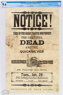
Sold20221968 AOR-3.104 Grateful Dead Portland Notice Poster 9.6Time for a Pacific Northwest POWERHOUSE! We are pleased to offer this amazing specimen of one of THE classic Grateful Dead concert posters from the 1960s. This stop on the PNW tour was at the PSC CollSee Sold Price
Jun 02Schilb Antiquarian Rare Books1880 Captain James Cook Voyages Hawaii Pacific Australia Kippis South Sea Navy$1(1 bid)
Jun 02Schilb Antiquarian Rare Books1848 1ed Wreck of the Glide Fiji & Wallis Islands Native Shipwrecks Dix Oliver$1(1 bid)
2 days LeftFreeman's | HindmanSir Jacob Epstein (British, 1880-1959) Tiger King (Man of Aran), conceived 1933$3,000
46 mins LeftJasper521798 La Perouse Map of the Samoan Islands -- Chart of the Archipelago of Navigators…$110
46 mins LeftJasper521775-1780 North West Africa with Cape Verde and Canary Islands. By Bonne and Raynal$20
2 days LeftWestern Trading PostTwo Limited Edition Drawings By Bill Owens And Robert "Shoofly" Shufelt$100
549 Lots AwayPacific Global Auction2021 1 Kilo Cook Islands Real Heroes Firefighter Silver Coin (Colorized, Box + CoA)$1(1 bid)
683 Lots AwayPacific Global Auction2019 British Virgin Islands 1 oz Silver Una & The Lion Frosted BU$1
Jun 02Schilb Antiquarian Rare Books1871 Alfred the Great King of England MAP Battle of Ashdown Vikings Thom Hughes$110(3 bids)


![Munson's A New Map of the Western Rivers, 1846: MUNSON, Sam[ue]l B[ishop] (1806-1880). A New Map of the Western Rivers. Or Travellers Guide Exhibiting the Mississippi, Missouri, Ohio, and Illinois Rivers, with all the Principal Towns, Islands & Dis](https://p1.liveauctioneers.com/1968/250616/130196575_1_x.jpg?height=310&quality=70&version=1654190895)


![Mitchell Map of Western U.S.: *** START PRICE IS THE RESERVE *** [America] MITCHELL, Samuel Augustus (1792-1868). A New Map of Texas, Oregon and California with the Regions Adjoining. Engraving with original hand color, with origi](https://p1.liveauctioneers.com/1968/163248/82424595_1_x.jpg?height=310&quality=70&version=1583340284)

![PETER DE SEVE: PETER DE SEVE (American, b. 1958), Coney Island boardwalk scene [New Yorker cover illustration], published September 6, 1993, pen, ink and watercolor on paper, signed lower right. Hinge-mounted, matte](https://p1.liveauctioneers.com/2331/293803/155976745_1_x.jpg?height=310&quality=70&version=1687549247)


![(CAPTAIN COOK.) John Webber, et al. [Atlas to] A Voyage to the Pacific Ocean.: (CAPTAIN COOK.) John Webber, et al. [Atlas to] A Voyage to the Pacific Ocean. 2 engraved maps, 61 engraved plates. Folio, 22½x17 inches, contemporary boards, well-worn and partly disbound; dampst](https://p1.liveauctioneers.com/199/251723/130782456_1_x.jpg?height=310&quality=70&version=1655133895)


![1598 Munster/Petri Maps of Elba [verso] Sicily -- Elba [verso] Sicilia (1 of 2)](https://p1.liveauctioneers.com/5584/328338/176911646_1_x.jpg?height=282&quality=70&version=1715113718)


![[SANTA FE RAILWAYS]. Two ATSF railroad prints. 1955. Includ... (1 of 3)](https://p1.liveauctioneers.com/928/325952/175495377_1_x.jpg?height=282&quality=70&version=1712935174)


