20182 World War II maps2 World War II maps. Pacific and European Theater. Title: 2 World War II map. Framed. Medium: Print. Size: 9.5 X 7.5See Sold Price
Sold20234 WWII Silk Pilots Escape or Invasion MapsGroup of 4 World War II era silk Air Force pilots escape maps, one of Sicily and Italy, Ryojun, Manchuria/Pei-P'Ing China, Otomari, Japan/Vladimiro-Aleksandrovskoye, Greece/Bulgaria-Romania 15" x 19"-See Sold Price
Sold20221946 Factual Chart of WWII Asiatic Pacific Operations MapFACTUAL CHART OF WORLD WAR II Asiatic-Pacific Operations folder and chart / poster with Generals and Admirals. The folder is 14 x 15 inches tall. The folding map poster itself is 38 x 57 inches. 1st eSee Sold Price
Sold2023WWII German Invasion of England 2nd Ed. MapsWorld War 2 german military plan maps of london, england invasion. 2nd edition, 1941. Includes 5 maps and folder. All maps are in tact, some yellowing and minor wear to fold creases due to age.See Sold Price
Sold2024WW2 Pacific Ocean. Japanese-occupied China Indochina Philippines 1942 old mapTITLE/CONTENT OF MAP: 'Pacific Ocean' DATE PRINTED: 1942 IMAGE SIZE: Approx 27.5 x 44.0cm, 10.75 x 17.25 inches (Large) TYPE: Vintage colour map CONDITION: Good; suitable for framing. However, pleaseSee Sold Price
Sold2021WWII UNITED PRESS WAR MAP w 7 INDIVIDUAL MAPS JAPANTitle: WWII UNITED PRESS WAR MAP w 7 INDIVIDUAL MAPS JAPAN HAWAII WORLD PACIFIC THEATER Additional Information: WWII UNITED PRESS WAR MAP w 7 INDIVIDUAL MAPS JAPAN HAWAII WORLD PACIFIC THEATER WWII UNSee Sold Price
Sold2018World War II Victory MapVictory in the Pacific. A pictoral map. Designed and published by Ernest Dudley Chase, Winchester Mass. Matted and framed Good condition S: 15.5 x 23.5 F: 26.5 x 34.5See Sold Price
Sold2020WWII US Army Medics Bullion Embroidered Ribbon BarSoutheast Asian made embroidered one piece ribbon bar with a bullion Combat Medic Badge, Bronze Star, Asiatic-Pacific Ribbon with invasion arrowhead, and more. This dates to 1960's era production baseSee Sold Price
Sold2022WW2 'WESTERN FRONT' in 1940. Bird's eye view before invasion of France 1940 mapTITLE/CONTENT OF MAP: 'Daily Mail Air-View Map of the Western Front' DATE PRINTED: 1940 IMAGE SIZE: Approx 97.0 x 74.0cm, 38 x 29 inches (Large) TYPE: Vintage colour map; Scale 10 miles: 1 inch CONDITSee Sold Price
Sold2022WWII Factual Chart of WWII World War Two Asiatic-Pacific Operations MapFACTUAL CHART OF WORLD WAR II Asiatic-Pacific Operations folder and chart / poster with Generals and Admirals. The folder is 14 x 15 inches tall. The folding map poster itself is 38 x 57 inches. 1st eSee Sold Price
Sold2022[WORLD WAR II]. Collection of photographs, Japanese maps, and a diary collected by USN Lt. Cmdr. J.[WORLD WAR II]. Collection of photographs, Japanese maps, and a diary collected by USN Lt. Cmdr. J. John Fox while stationed in the Pacific, including: 53 reconnaissance photos from the Battle of OkinSee Sold Price
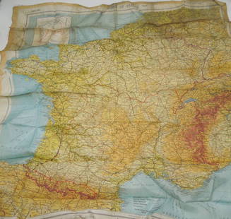
Sold2023WWII March 1944 Zones of France Silk Escape MapMarch 1944 Original silk escape map of France. This would be the type of item carried by US Paratroopers during the Invasion of Normandy, as well as US aviators flying missions over France.See Sold Price
Sold2022WWII US 10th Army Infantry Captain Uniform Pacific CIB, Bronze Star Medal, Purple HeartPacific Theater (PTO) / Tenth Army WWII Infantry Captain's uniform named to Stevens. Sterling CIB, plastic covered ribbons with 2x BSM’s, PH, and Invasion Arrowhead, bullion overseas bars, etc.See Sold Price
Sold2023German invasion of Belgium and France, May-June 1940. World War 2 1953 old mapTITLE/CONTENT OF MAP: 'The German assault in the west, May-June, 1940' DATE PRINTED: 1953 IMAGE SIZE: Approx 19.0 x 25.0cm, 7.5 x 10 inches (Medium); Please note that this is a folding map. TYPE: VintSee Sold Price
Sold2023WORLD WAR 2. Maginot & Siegfried line defences. Pre-invasion of France 1940 mapTitle: WORLD WAR 2. Maginot & Siegfried line defences. Pre-invasion of France 1940 map Description: Western Front showing forests and main defences: Section 1' by George Philip & Son (March 1940). VinSee Sold Price
Sold2023WORLD WAR 2. Maginot & Siegfried lines defences. Pre-invasion. Belgium 1940 mapTitle: WORLD WAR 2. Maginot & Siegfried lines defences. Pre-invasion. Belgium 1940 map Description: Western Front showing forests and main defences: Section 2' by George Philip & Son (March 1940). VinSee Sold Price
Sold2022German invasion of Belgium and France, May-June 1940. World War 2 1953 old mapTITLE/CONTENT OF MAP: 'The German assault in the west, May-June, 1940' DATE PRINTED: 1953 IMAGE SIZE: Approx 19.0 x 25.0cm, 7.5 x 10 inches (Medium); Please note that this is a folding map. TYPE: VintSee Sold Price
Sold2019World War 2 U.S. Navy PhotographsMagazine of Photographs of the U.S. Navy in the Pacific from Pearl Harbor to Tokyo Bay.See Sold Price
Sold[WWII]. Diary and ephemera archive of Emerson J. Duricky, 3rd Brigade Army, Amphibious.[WWII]. Diary and ephemera archive of Emerson J. Duricky, 3rd Brigade Army, Amphibious. World War II Pacific Theatre archive including an 85pp diary, documents, terrain maps, reunion poster, postcardsSee Sold Price
Sold2022DOUGLAS MACARTHUR(1880 - 1964) American general and Allied Supreme Commander in the Pacific in World War II, accepted the surrender of Japan and was later dismissed by Truman for advocating an invasion of China. GlossSee Sold Price
Sold2023DOUGLAS MACARTHUR(1880 - 1964) American general and Allied Supreme Commander in the Pacific in World War II, accepted the surrender of Japan and was later dismissed by Truman for advocating an invasion of China. SignaSee Sold Price
Sold2021INVADER 'Invasion Map NYC' Lithograph Print'Invasion Map New York City' by Invader, 2003 16.5 x 23.6 Inches Offset lithograph on fine art paper. Open edition (Sold Out). Mint Condition. Ships folded. ARTIST BIO Invader is one of the most enSee Sold Price
Sold2024Very Rare Original Ephemera WW2 Pacific War PropagandaThe dimensions of these items are in average (some differences can occur) 5" to 10" by 6" to 8". This lot is located in Boca Raton, Fl and its shipment will be made directly by Artelisted. Shipping inSee Sold Price
Sold2024Very Rare Original Ephemera WW2 Pacific War PropagandaProvenance from the estate of a Military Museum in South Florida. This lot is located in Boca Raton, Fl and its shipment will be made directly by Artelisted. Shipping insurance is the responsibility oSee Sold Price
2 days LeftJasper521753 Prevost Map of Pacific Wind Currents -- Representation du Cours ordinaire des Vents de Traverse$85
383 Lots AwayKey Date CoinsLot of 5 Different WWII Japanese Invasion Currency Notes, Various Denominations & Countries$25
19 hrs LeftKey Date CoinsLot of 19 WWII Occupation Japanese Invasion Money Notes - Various Countries & Denominations Grades$90
4 days LeftRail & Road Auctions1951 Chicago, Milwaukee, St. Paul & Pacific Railroad Wall Map - Route of the Hiawathas$50
2 days LeftJasper521884 Rand McNally Map of US Railroad System -- Map Exhibiting the Several Pacific Railroads Prepared$140
6 days LeftTrillium Antique Prints & Rare BooksPrevost - Map of the South Pacific Ocean with New Holland (Australia), New Zealand, and part of the$50(1 bid)
4 days LeftRail & Road Auctions1961 Chicago, Milwaukee, St. Paul & Pacific Railroad Polychrome Wall Map$50
May 17Albion AuctionsStieler, Adolf 1909 Antique Map. New Zealand - South Sea Islands, Pacific Australia Hawaii$5
May 25Eagles Corps International LLCRare Named WW2 WWII 105th regiment 27th infantry division Okinawa invasion WIA Purple heart and$5(1 bid)


![[WORLD WAR II]. Collection of photographs, Japanese maps, and a diary collected by USN Lt. Cmdr. J.: [WORLD WAR II]. Collection of photographs, Japanese maps, and a diary collected by USN Lt. Cmdr. J. John Fox while stationed in the Pacific, including: 53 reconnaissance photos from the Battle of Okin](https://p1.liveauctioneers.com/197/250551/130130063_1_x.jpg?height=310&quality=70&version=1654185975)


![[WWII]. Diary and ephemera archive of Emerson J. Duricky, 3rd Brigade Army, Amphibious.: [WWII]. Diary and ephemera archive of Emerson J. Duricky, 3rd Brigade Army, Amphibious. World War II Pacific Theatre archive including an 85pp diary, documents, terrain maps, reunion poster, postcards](https://p1.liveauctioneers.com/197/293791/155970355_1_x.jpg?height=310&quality=70&version=1688592569)


