Sold2016A Group of Four Hand-colored Engraved Maps, 19th/20thA Group of Four Hand-colored Engraved Maps, 19th/20th Century, Including three maps by Gerardus Mercator depicting Austria Archiducatus, Saltzburg and Flanders, and one map by Frederick de Wit depictiSee Sold Price
Sold2016Two Framed Hand-colored Engraved Maps, 19th/20thTwo Framed Hand-colored Engraved Maps, 19th/20th Century, Including a map of Morea olim Peloponnesus by Gerardus Mercator and of Deventer by Johannes Blaeu. Largest framed dimensions: h: 21 1/2 x w: 2See Sold Price
Sold2018Maps 19th Century. Mixed Lot of 9Engraved and Lithographed Maps, 19th Century (2 are 1911) Incl France, Netherlands, Israel/Palestine, USA, Europe, Switzerland, Bedfordshire and Ancient Britain. Examples by SDUK, Dugdale/Archer, EncySee Sold Price
Sold2018Engraved map of Canada and United StatesCarte de la Region Orientale des Etats-Unis et de la dominion du Canada, 19th century, engraved map with hand coloring, designed by A. Brue, overall (with frame): 19.5"h x 25"wSee Sold Price
Sold2023V. Levasseur MapVictor Levasseur, French, 1800-1870. A mid 19th century engraved map with hand-coloring, titled "Dept. de L'Aude". Very slight foxing. Image 17 1/4 x 12 1/2" high, in a contemporary composite frame wiSee Sold Price
Sold20221874 map of Western states & territories, MitchellInteresting and uncommon variant transitional issue that appeared in only a few editions of Mitchell’s New General Atlas. Fine 19th century engraved (lithographed) map, with original hand color. ShoSee Sold Price
Sold2018ACUÑA, Cristóbal de (1597-1676?). Voyages andACUÑA, Cristóbal de (1597-1676?). Voyages and Discoveries in South-America. London: for S. Buckley, 1698. 8vo (190 x 111 mm). 2 folding engraved maps; 3 title-pages. (Pale spotting.) 19th-century taSee Sold Price
Sold2020Framed map of Ireland, circa 1886Late 19th century colored map of Ireland engraved by the People's Publishing Co., Chicago, circa 1886, 16.5"h x 11.25"w sight of sheet, overall dimensions including frame 27.5"h x 21.75"w x 1.75"d.See Sold Price
Sold2020Brown Map of the Caribbean*** START PRICE IS THE RESERVE *** [America] BROWN, J. (19th Century). West India Islands. Engraved Map with original hand color in outline. Edinburgh, early 19th Century. 8 3/8" x 10 3/8" visible, 15See Sold Price
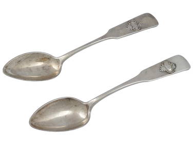
Sold2017LOT (5) ENGRAVED MAPS INCLUDING MARTINIQUE, FROM PETITLOT (5) ENGRAVED MAPS INCLUDING MARTINIQUE, FROM PETIT ATLAS NATIONAL, 19TH CENTURY, 10 X 8"; WINDWARD ISLANDS (ST. LUCIA, ST. VINCENT AND BARBADOS), T. KITCHIN, 18TH CENTURY, 10 1/4 X 8"; ANTILLES ORSee Sold Price
Sold20232 Malham's Naval Gazetteer MapsTwo early 19th century Malham's Naval Gazetteer engraved maps with hand-coloring. Includes "A Correct Chart of the West Indes" and "A Correct Chart of the Coasts of South America". Both dated "1801" uSee Sold Price
Sold2019Large map of Africa in early 19th centuryHeading: Author: Bordiga Fratelli Title: Carta dell' Affrica Place Published: [Milan, Italy] Publisher:Fratelli Bordiga Date Published: [1818?] Description: Copper-engravedSee Sold Price
Sold2022British Isles.- Davies (Benjamin Rees) Davies's New Map of the British Metropolis, 19th century;British Isles.- Davies (Benjamin Rees) Davies's Map of the British Metropolis, showing from Shepherd's Bush to West Ham, and Camberwell to Stoke Newington, engraved map, 665 x 935 mm (26 1/4 x 36 3/4See Sold Price
Sold2019Maps 19th Century. Mixed Lot of 7Lot of 7 Lithographed and Engraved Maps. Incl Europe Continent, Italy (Part Map) South Africa, Worcester/Gloucester, Huntingdonshire, Africa and UK. Examples by Stieler, Weekly Dispatch, Guthrie, JohnSee Sold Price
Sold2020Maps 19th Century. Mixed Lot of 8Lot of 8 Lithographed and Engraved Maps. Incl Europe Continent, Italy (Part Map) South Africa, Worcester/Gloucester, Huntingdonshire, Asia and UK. Examples by Stieler, Weekly Dispatch, Goldsmith, JohnSee Sold Price
Sold2018Maps 19th Century. Mixed Lot of 7Lot of 7 Lithographed and Engraved Maps. Incl Europe Continent, Italy (Part Map) South Africa, Worcester/Gloucester, Huntingdonshire, Africa and UK. Examples by Stieler, Weekly Dispatch, Guthrie, JohnSee Sold Price
Sold2022Two atlases 19th centuryTwo atlases 19th century comprising: Mitchell, S. Augustus. Mitchell's New General Atlas. Philadelphia: S. A. Mitchell, 1869. Folio (330 x 395mm), 40 (of 60) hand-coloured engraved maps, contemporarySee Sold Price
Sold20243 Engraved Maps Rhode Island, Connecticut, Mass3 engraved maps. F.W. Beers & Co. Somerset Village, Massachusetts, circa late 1800s, 14 1/2" x 11" (with frame 19 1/4" x 15 3/4"); Rhode Island, circa late 18th-early 19th century, 7 1/2" x 6 3/8" (wiSee Sold Price
Sold2018LOT (4) ENGRAVED MAPS INCLUDING ENVIRONS OF JERUSALEM,LOT (4) ENGRAVED MAPS INCLUDING ENVIRONS OF JERUSALEM, ROBINSON & SMITH, 1841, 13 3/4 X 18"; SYRIA R.B. DAVIES, 19TH CENTURY, 10 1/2 X 8 1/2"; THE ROMAN ROADS OF BRITAIN, THOMAS LEMAN, 1817, 18 3/8 XSee Sold Price
Sold2022SEVEN ENGRAVED MAPS.European, 18th-19th century. Printed with some hand coloring. Four on laid paper including three German and French military maps, "Plan des Camps de Pisek, 1741", 15.25"h. 20.25"w., battles of PeterwaSee Sold Price
Sold2024Tasso Italian Map the United States 1832TASSO, G. (19th Century). Stati-Uniti dell' America Settentrionale dalle Piu Recenti Mappe... Engraved map with original hand color. Venice, 1832. 15 1/4" x 19 3/4" sheet. Scarce map from an Italian eSee Sold Price
Sold2018Miller Map of the US with Presidential PortraitsMiller, William (19th Century). Map of the United States (with 13 presidential portraits + Capitol in Washington (unfinished). Engraved map. Ohio: William & Thomas Miller, 1852. 23 ½" x 31" sheet.See Sold Price
Sold2017Early Map of Georgia, John Payne, Circa 1810John Payne (American, 18th/19th century), "Georgia from the latest Authorities 1810"-1810/11. An early American engraved map of the Southern United States by mapmaker John Payne (American, 18th/19th cSee Sold Price
Sold2016Antique Map, County of Southampton, Greenwood & Co.Greenwood & Co. (British, 19th century), "Map of the county of Southampton from an Actual Survey, made in the years 1825 & 1826," hand-colored copper-engraved map, engraved by J. and J. Neele, publishSee Sold Price
Jun 14Antique Kingdom19th C. French Guillaume Grohe Signed Louis XVI Engraved Figural Commode Cabinet$6,000
3 days LeftFive Star Auctions19th C. German Engraved Sterling Silver Glass Candy Dish, Hallmarked$600
3 days LeftFive Star AuctionsA Large 19th C. French Engraved Figural Bronze Framed wall Hanging$4,500
4 days LeftWorthington Galleries19th c. Hemisphere World Map, Hohen und Tiefen der Erde in Lambert’s Zenithal-Projection von$10


![Brown Map of the Caribbean: *** START PRICE IS THE RESERVE *** [America] BROWN, J. (19th Century). West India Islands. Engraved Map with original hand color in outline. Edinburgh, early 19th Century. 8 3/8" x 10 3/8" visible, 15](https://p1.liveauctioneers.com/1968/163248/82424566_1_x.jpg?height=310&quality=70&version=1583340284)


![Large map of Africa in early 19th century: Heading: Author: Bordiga Fratelli Title: Carta dell' Affrica Place Published: [Milan, Italy] Publisher:Fratelli Bordiga Date Published: [1818?] Description: Copper-engraved](https://p1.liveauctioneers.com/642/151690/76551225_1_x.jpg?height=310&quality=70&version=1570486555)