Sold2022(PICTORIAL MAPS -- MANUSCRIPT.) [New York City, Queens, 1776].(PICTORIAL MAPS -- MANUSCRIPT.) [New York City, Queens, 1776]. Pen and ink on heavy artist's stock. 15¾x21½ inches sheet size, wide margins; vertical fold at center. Np, mid-19th century ManSee Sold Price
Sold20181968 Bollmann Pictorial Map of New York City -- NewTitle/Content of Map: 1968 Bollmann Pictorial Map of New York City -- New York Picture and Street Map Date Printed: 1968, Braunschweig, Germany Cartographer: H Bollmann, published by Bollmann BildkartSee Sold Price
Sold2023M. Dripps - Maps of New York City, Group of 3Lot 40 M. Dripps American (1812 - 1896) Maps of New York City, Group of 3 (1860) lithograph with hand coloring including New York City and Vicinity by M. Dripps, The Reaches of New York City by NationSee Sold Price
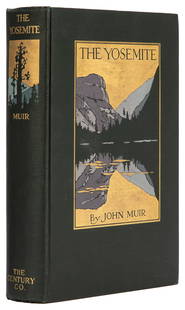
Sold2023 MUIR, John (1838-1914). The Yosemite. New York: The Century...MUIR, John (1838-1914). The Yosemite. New York: The Century Co., 1912. 8vo. 32 full-page plates from photographs, 3 folding maps. Original pictorial dark green cloth, top edge gilt (small spot of ghosSee Sold Price
Sold2022Old Houses in England, Chunter, 1930CHUNTER, ROWLAND. Old Houses in England. New York: John Wiley & Sons; London: Chapman & Hall, 1930. Folio (13 3/4" x 10 3/4"). Red gilt cloth, pictorial map endpapers. Full-page black and white photogSee Sold Price
Sold2022(NEW YORK CITY.) [Joseph Shannon]. Group of 3 folding plates taken from the 1868 Manual of the(NEW YORK CITY.) [Joseph Shannon]. Group of 3 folding plates taken from the 1868 Manual of the Corporation of the City of New York. New York, 1868 - Map of the City of New York. Hand-colored lithograpSee Sold Price
Sold2021Pictorial Map Mohawk IndiansMap of the Land of The Mohawks of Sir William Johnson, of the Palatines and the Mohawk Dutch. Edwin G. Conde, 1932. Native Americans historical map, Counties in New York State. 18 3/4" x 34 1/4".See Sold Price
Sold2023Antique & Vintage Ephemera, NYC Maps & MoreA group lot of vintage and antique ephemera. Primarily New York / New York City ephemera. Maps, bookmarks, and more. One small book measuring 3.5H x 2.5W titled OLD NEW YORK, by HENRY COLLINS BROWN, CSee Sold Price
Sold2023MISC. HISTORICAL BOOKSDARWINISM AN EXPOSITION OF NATURAL SELECTION by Alfred Russell Wallace New York 1889 – With map and illustrations ARIZONA HISTORICAL REVIEW (Vol. 3 #3) July 1936 THE PEOPLES PICTORIAL EDITION.See Sold Price
Sold2022[MAP-CUBA] Official Map of Cuba. Folding lithographic map of Cuba published in Trumbull White's[MAP-CUBA] Official Map of Cuba. Folding lithographic map of Cuba published in Trumbull White's Pictorial History of Our War With Spain, 1898. An inset features the city plan of Havana and text headedSee Sold Price
Sold2022Encyclo. Britannica C1880 Lot 3 Maps. New York City & StateTwo City Plans and a State Map. Lithograph Maps Published 1875-98, Edinburgh & London for "Encyclopaedia Britannica" Ninth Edition. Paper Size: 10.5 x 8 inch (27 x 21cm) and 15.5 x 10.5 inch (39 x 27cSee Sold Price
Sold2020Karamojo Safari by Bell 1949Karamojo Safari by W. D. M. Bell. 1949 with dust jacket price unclipped. Harcourt, Brace and Co., New York. 298 pp. with pictorial map endsheets. Measures 8.375 in. x 5.75 in. x 1.25 in. From a non-smSee Sold Price
Sold20231938 R Taylor White Pictorial Map of New York -- New YorkTitle: 1938 R Taylor White Pictorial Map of New York -- New York Cartographer: Ruth Taylor White Year / Place: 1938, Boston Map Dimension (in.): 11.6 x 8.5 in. This is Ruth Taylor White's charming picSee Sold Price
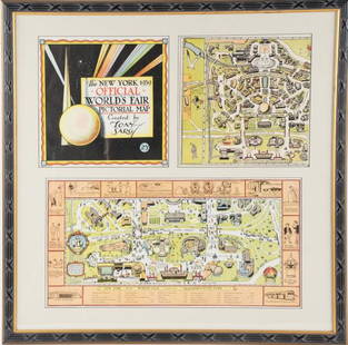
Sold2022Framed Tony Sarg 1939 World's Fair Pictorial MapTony Sarg (American, 1880-1942), "The New York 1939 Official World's Fair Pictorial Map Created by Tony Sarg 25¢" cover and Transportation Zone maps, three pieces matted and under glass in paintedSee Sold Price
Sold2022A RARE GRIBBROEK 1935 NATIVE AMERICAN POSTERRobert Gribbroek (1906-1971) historical pictorial map of New York State focused on its Native American tribes by Arthur Caswell Parker (1881-1955). Filled with portraits of prominent persons and sceneSee Sold Price
Sold2022FLICK, Alexander C. -- PAINE, Paul M. A Map of the History ...FLICK, Alexander C. -- PAINE, Paul M. A Map of the History of New York State. 1928. New York: R.R. Bowker Co. Historical pictorial map of New York with insets of Old New York, Niagara, Tip of Long IslSee Sold Price
Sold2023A Decorative Pictorial Map of The New York Worlds Fair by William L. Longyear (American, 1899-1980)A Decorative Pictorial Map of The New York Worlds Fair by William L. Longyear (American, 1899-1980). Framed. Designed and copyrighted by William Longyear. Lithographed in U.S.A by Polygraphic CompanySee Sold Price
Sold1939 New York World's Fair Official World's Fair Pictorial Map1939 New York Worlds Fair Official Worlds Fair Pictorial Map by Tony Sarg in very good to excellent condition as seen in the photos.See Sold Price
Sold2022Lot of 3 Various Maps of New York CityLot of 3 various maps of New York City, all show various stages of wear, yellowing, slight age staining & some ripping (mostly at the folds): Panorama of the New York Zoological Park, The Supervue MapSee Sold Price
Sold2021(PICTORIAL MAPS -- CHINA.) Group of 3 large offset(PICTORIAL MAPS -- CHINA.) Group of 3 large offset color-printed posters of Chinese natural and cultural heritage sites. China, mid-twentieth century *Taishan Mingsheng Tu. Scenic trail map of Mount TSee Sold Price
Sold2021(PICTORIAL MAPS.) Robert J. Seymour; and Merritt L.(PICTORIAL MAPS.) Robert J. Seymour; and Merritt L. Ryder. Historical Westchester County. Color-printed pictorial map of Westchester County, New York. 22x17 inches sheet size, wide margins; old folds,See Sold Price
Sold2022Marvelous pictorial map of the WorldHeading: (Maps) Author: Ensign & Thayer Title: World at One View Place Published: New York Publisher: Date Published: 1847 Description: Lithographed double-hemisphere map of theSee Sold Price
Sold2023[PICTORIAL MAPS]. Six travel maps and brochures. Includes: ...[PICTORIAL MAPS]. Six travel maps and brochures. Includes: RENTSCHLER, F. Historical Map of the Old Northwest Territory. 1937. New York: Farrar and Rinehart Inc. 23 x 17 ¼”. Folded. StoredSee Sold Price
Sold2024Pictorial Map of the United States, 1849PICTORIAL MAP OF THE UNITED STATES 1849. New York: Ensign and Thayer, [ca. 1849.] Sheet 44" x 32.25".*** An attractive hand-colored map providing a view of the United States as it was in the mid-19thSee Sold Price
Jun 09Estate Collection Auctioneer1986 Photo The Staten Island Anchorage viewed from Narrows Bridge Tower$250
6 days LeftJasper521874 Holmes Plan of New York's Upper East Side -- Map of the Common Lands from 76th to 93rd Street$750


![(PICTORIAL MAPS -- MANUSCRIPT.) [New York City, Queens, 1776].: (PICTORIAL MAPS -- MANUSCRIPT.) [New York City, Queens, 1776]. Pen and ink on heavy artist's stock. 15¾x21½ inches sheet size, wide margins; vertical fold at center. Np, mid-19th century Man](https://p1.liveauctioneers.com/199/251723/130782406_1_x.jpg?height=310&quality=70&version=1655133895)
![[NEW YORK CITY – PICTORIAL MAPS]. Group of 3 pictorial maps... First Image](https://p1.liveauctioneers.com/928/325952/175495562_1_x.jpg?height=300&quality=1&version=1712935174&width=300)
![[NEW YORK CITY – PICTORIAL MAPS]. Group of 3 pictorial maps... First Image](https://p1.liveauctioneers.com/928/325952/175495562_1_x.jpg?height=300&quality=95&version=1712935174&width=300)


![(NEW YORK CITY.) [Joseph Shannon]. Group of 3 folding plates taken from the 1868 Manual of the: (NEW YORK CITY.) [Joseph Shannon]. Group of 3 folding plates taken from the 1868 Manual of the Corporation of the City of New York. New York, 1868 - Map of the City of New York. Hand-colored lithograp](https://p1.liveauctioneers.com/199/251723/130782382_1_x.jpg?height=310&quality=70&version=1655133895)


![[MAP-CUBA] Official Map of Cuba. Folding lithographic map of Cuba published in Trumbull White's: [MAP-CUBA] Official Map of Cuba. Folding lithographic map of Cuba published in Trumbull White's Pictorial History of Our War With Spain, 1898. An inset features the city plan of Havana and text headed](https://p1.liveauctioneers.com/292/250642/130213661_1_x.jpg?height=310&quality=70&version=1654271664)


![[PICTORIAL MAPS]. Six travel maps and brochures. Includes: ...: [PICTORIAL MAPS]. Six travel maps and brochures. Includes: RENTSCHLER, F. Historical Map of the Old Northwest Territory. 1937. New York: Farrar and Rinehart Inc. 23 x 17 ¼”. Folded. Stored](https://p1.liveauctioneers.com/928/305275/163151901_1_x.jpg?height=310&quality=70&version=1697054833)
![Pictorial Map of the United States, 1849: PICTORIAL MAP OF THE UNITED STATES 1849. New York: Ensign and Thayer, [ca. 1849.] Sheet 44" x 32.25".*** An attractive hand-colored map providing a view of the United States as it was in the mid-19th](https://p1.liveauctioneers.com/3532/326332/175680404_1_x.jpg?height=310&quality=70&version=1713150771)


