Sold2023Antique Nautical Chart of the Philippines: Manila Galleons Route by English Pirate George Anson,Title: Antique Nautical Chart of the Philippines: Manila Galleons Route by English Pirate George Anson, 1749 Date/Period: 1749 Materials: Copper plate engravedSize: 21 1/4 x 16 3/4”. Step into tSee Sold Price
Sold2023Nautical Chart of Manila by the English pirate Anson. 1749Title: Nautical Chart of Manila by the English pirate Anson. 1749 Date/Period: 1749 Materials: Copper plate engraved Size: 10 x 9 3/4” Nautical chart of Manila, Philippines. Showing the city andSee Sold Price
Sold2022Nautical chart of the Pacific Ocean, showing the route of the famous Spanish treasure’ManilaTitle: Nautical chart of the Pacific Ocean, showing the route of the famous Spanish treasure’Manila Galleons’, by the English pirate Anson. 1749 Date/Period: 1749 Materials: Copper plateSee Sold Price
Sold2022Nautical chart of Acapulco by the English pirate Anson, 1749Title: Nautical chart of Acapulco by the English pirate Anson, 1749 Date/Period: 1749 Materials: Copper plate engraved Size: 10 x 7 1/4 “ Nautical chart of the port of Acapulco, Mexico. By the ESee Sold Price
Sold2022Nautical chart of Petatian near Acapulco by the English pirate Anson, 1749Title: Nautical chart of Petatian near Acapulco by the English pirate Anson, 1749 Date/Period: 1749 Materials: Copper plate engraved Size: 15 1/2 x 10” Nautical chart of Petatian, near Acapulco,See Sold Price
Sold2022Nautical chart of Coiba island, Panama, by the English pirate Anson. 1749Title: Nautical chart of Coiba island, Panama, by the English pirate Anson. 1749 Date/Period: 1749 Materials: Copper plate engraved Size: 15 1/2 x 10” Nautical chart of the east end of Quibo (CoSee Sold Price
Sold2022Nautical chart of the attack by five ships on Acapulco, by the English pirate Anson. 1749Title: Nautical chart of the attack by five ships on Acapulco, by the English pirate Anson. 1749 Date/Period: 1749 Materials: Copper plate engraved Size: 15 1/2 x 10” Nautical chart of the attacSee Sold Price
Sold2022Nautical chart of Juan Fernandez island. (Robinson Cruseo is) by the English pirate Anson, 1749Title: Nautical chart of Juan Fernandez island. (Robinson Cruseo is) by the English pirate Anson, 1749 Date/Period: 1749 Materials: Copper plate engraved Size: 15 1/2 x 10” Nautical chart of JuaSee Sold Price
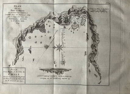
Sold2022Nautical chart of a unidentified bay in Chile. By the English pirate Anson 1749Title: Nautical chart of a unidentified bay in Chile. By the English pirate Anson 1749 Date/Period: 1749 Materials: Copper plate engraved Size: 13 1/2 x 9 3/4” Nautical chart of a unidentified BSee Sold Price
Sold2023Nautical chart of Chequetan harbor near Acapulco, by the English pirate AnsonTitle: Nautical chart of Chequetan harbor near Acapulco, by the English pirate Anson Date/Period: 1749 Materials: Copper plate engraved Size: 15 1/2 x 10" Nautical chart of Chequetan or Seguaaneo, harSee Sold Price
Sold2023Antique Nautical Chart of Juan Fernandez Island: Northeast Side by English Pirate George Anson,1749Title: Antique Nautical Chart of Juan Fernandez Island: Northeast Side by English Pirate George Anson,1749 Date/Period: 1749 Materials: Copperplate engraved Size: 15 1/2 x 10” Explore the legendSee Sold Price
Sold2016Carte du Canal des Isles Philippines, G. Anson 1749Title: Carte du Canal des Isles Philippines Subject: Philippines Maker: George Anson Date: 1749, London Size: 21 x 16.5 inches Chart of the Philippines showing the route of the Spanish treasure ships,See Sold Price
Sold2016Original Imray East India Archipelago Chart No. 4Imray & Son 1880 marine chart of East India Archipelago, showing the western route to China, marine chart No. 4. Stamped with 1881. Shows Borneo, and detailed marine charts of Bruni and Labouan, PalawSee Sold Price
Sold2020Japan. Seto inner sea.Japan. Seto inner sea.XIXth century, [Edo period]Manuscript nautical chart, mm. 3300 x 5750. Very rare commercial nautical chart engraved on wood with the commercial nautical routes highlighted in redSee Sold Price
Sold2023A Fine English Sailor Made (?) Nautical WoolieFramed English warship Woolie showing a vessel on a deep blue sea flying a large number of flags and pennants. Several Union Jacks / Union Jack variants are visible. Attractively framed. Image 14.5&quSee Sold Price
Sold2017SPANISH GALLEON PIRATE SHIP MODELA large and impressive model of the Spanish galleon San Francisco, hand built by Kladiusz Marczuk. The ship features a remote controlled electric motor among other embellishments and sits atop a fitteSee Sold Price
Sold2023VERY RARE 1908 MANILA, PHILIPPINES CARNIVAL POSTERVERY RARE 1908 MANILA, PHILIPPINES CARNIVAL POSTER, lithograph on paper, full-sheet, depicting the Red Devil sprinkling "joy dust" on carnival revelers, signed "Fuster / 1908" in tSee Sold Price
Sold2022MIGUEL ZARAGOZA ARANQUIZNA (Philippines, 1842- Manila, 1923). "Spoliarium". Oil on canvas. ItMIGUEL ZARAGOZA ARANQUIZNA (Philippines, 1842- Manila, 1923). "Spoliarium". Oil on canvas. It has slight restorations. Signed in the lower right corner. Measurements: 50 x 90 cm. This work reproducesSee Sold Price
Sold2019Felix R.Hidalgo(1855-1913)Spain,Philippines Oil"ManilaFelix R. Hidalgo (1855 - 1913) Spain, Philippines Oil "Manila View" Felix Resurreccion Hidalgo (1855 - 1913) Felix Resurreccion Hidalgo was active/lived in Spain, Philippines. Felix Hidalgo is known fSee Sold Price
Sold2020Alfonso A Ossorio Mixed Media BoardAttributed to Alfonso A Ossorio (1916 - 1990). It does not have a COA. Provenance: private collection. Biography: Alfonso Ossorio was born in Manila in the Philippines on August 2, 1916. He moved to tSee Sold Price
Sold2022Baul MundoBaul Mundo Binondo, Manila1565–1815 (Galleon Trade between Manila and Acapulco) kalantas wood (Philippine cedar) 20" x 31" x 18" (51 cm x 79 cm x 46 cm) PROVENANCECollection of Don Zacharias RoSee Sold Price
Sold2022ARROWSMITH, AARON. Chart of the Pacific Ocean.ARROWSMITH, AARON. Chart of the Pacific Ocean. Large engraved navigational chart of the coastlines of Russia, Japan, Korea, China, the Philippines, Indonesia, and Australia. 73¼x31½ inches oSee Sold Price
Sold2023EXCEPTIONAL ENGLISH BRACKET CLOCKLondon, circa 1770, made for the Spanish market by London clockmakers Perkins & Spencer (working 1765-1775), showing a finely crafted mahogany bell top case profusely decorated with running bands of oSee Sold Price
Sold2022A White and Russet Jade Mythical Beast, Han Dynasty (private English collection)A White and Russet Jade Mythical Beast, Han Dynasty (private English collection) crouched and ready for the hunt, its head slightly raised showing its bulging eyes and its sharp fangs tucked in its opSee Sold Price
Jun 08Leon GalleryPhilippe de Pretot, Etienne Andre (c. 1710 - 1787) and William Walton - Carte de Canal des Isles₱30,000
2 days LeftThe Bidder AuctionsThe map of the railways in the Land of Israel - published by the Surveying Department of the British$30
5 days LeftSchilb Antiquarian Rare Books1831 PIRATES in America TORTUGA Capt Morgan Buccaneers Drake Cavendish Voyages$88(9 bids)
5 hrs LeftA & A Auction GalleryPr Bosun English Nautical Brass Oil Lights - Both w/ Plaques - 6.5'' x 4.5'' x 17'' From Capitola$60(1 bid)
Jun 18DOYLE Auctioneers & AppraisersA gentleman's hand-held mechanical scoring device for billiards$375(3 bids)
Jun 05Lion Heart AutographsExceptionally Rare and Stunning Jacqueline Du Pre Signed Photograph$400(1 bid)
Jun 08Simpson Galleries, LLC.JULIUS BIEN (1826-1909) AN AMERICAN CIVIL WAR RECONNAISSANCE MAP, "Map of Texas and Part of New$100
20 hrs LeftCedarburg Auction & Appraisals LLCSet of Four Maps Showing All of Spain and Portugal c. 1700's$450(2 bids)


![Japan. Seto inner sea.: Japan. Seto inner sea.XIXth century, [Edo period]Manuscript nautical chart, mm. 3300 x 5750. Very rare commercial nautical chart engraved on wood with the commercial nautical routes highlighted in red](https://p1.liveauctioneers.com/3336/174968/90450870_1_x.jpg?height=310&quality=70&version=1600527463)


![[MAP]. SPEED, John. A New Mappe of the Romane Empire. 1676. (1 of 2)](https://p1.liveauctioneers.com/197/329395/177650541_1_x.jpg?height=282&quality=70&version=1715364962)


