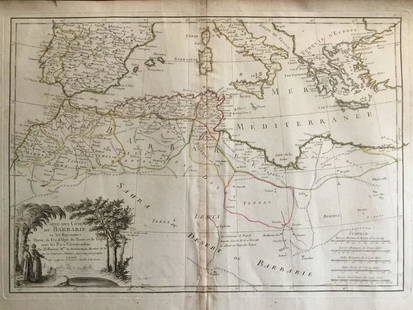
Sold2020Barbary coat. North west Africa. Morocco, Tunisia,Title: Barbary coat. North west Africa. Morocco, Tunisia, Algeria and Libya.. Date/Period: 1762 - 1771 Materials: Copperplate engraved Size: 20”x 14 1/2”. Barbary coast, shows North African countrSee Sold Price
Sold20241837. Map of Barbary Coast. Northwest Africa. Morocco, Algeria, Libya and Tunisia. By A. PerrotTitle: 1837. Map of Barbary Coast. Northwest Africa. Morocco, Algeria, Libya and Tunisia. By A. Perrot Date/Period: 1837 Materials: Hand-colored steel engraving Size: 7 x 10 3/4” This is a map oSee Sold Price
Sold2024NORTH AFRICA. Morocco Algeria Tunis Tunisia Egypt. Cairo. BARTHOLOMEW 1901 mapTITLE/CONTENT OF MAP: 'Morocco, Algeria, & Tunis; Upper & Lower Egypt; Inset map of Cairo' DATE PRINTED: 1901 IMAGE SIZE: Approx 33.5 x 44.0cm, 13.25 x 17.25 inches (Large); Please note that this is aSee Sold Price
Sold2023NORTH AFRICA. Morocco Algeria Tunis Tunisia Egypt. Cairo. BARTHOLOMEW 1901 mapTITLE/CONTENT OF MAP: 'Morocco, Algeria, & Tunis; Upper & Lower Egypt; Inset map of Cairo' DATE PRINTED: 1901 IMAGE SIZE: Approx 33.5 x 44.0cm, 13.25 x 17.25 inches (Large); Please note that this is aSee Sold Price
Sold2023South America north west. Peru Bolivia Ecuador Columbia. HUGHES 1876 old mapTitle: South America north west. Peru Bolivia Ecuador Columbia. HUGHES 1876 old map Description: [South America north west] by William Hughes (1876). Antique hand coloured engraved map, 30.0 x 24.5cm,See Sold Price
Sold2023World's highest waterfalls & biggest lakes. HUGHES 1876 old antique map chartTITLE/CONTENT OF MAP: 'Waterfalls. Lakes' DATE PRINTED: 1876 IMAGE SIZE: Approx 25.0 x 30.5cm, 9.75 x 12 inches (Large) TYPE: Antique hand coloured engraved map CONDITION: Good; suitable for framing.See Sold Price
Sold2023South America. Bolivia w/ Littoral. HUGHES 1876 old antique map plan chartTitle: South America. Bolivia w/ Littoral. HUGHES 1876 old antique map plan chart Description: South America' by William Hughes (1876). Antique hand coloured engraved map, 30.5 x 26.0cm, 12 x 10.25 inSee Sold Price
Sold2023AFRICA. Pre 'Scramble for Africa'. BARTHOLOMEW 1876 old antique map plan chartCAPTION PRINTED BELOW PICTURE: 'Africa' DATE PRINTED: 1876 IMAGE SIZE: Approx 31.0 x 24.0cm, 12.25 x 9.25 inches (Large); Please note that this is a folding map. TYPE: Antique colour map CONDITION: GoSee Sold Price
Sold2024North East Africa 1885 old antique vintage map plan chartTITLE/CONTENT OF MAP: 'North East Africa' DATE PRINTED: 1885 IMAGE SIZE: Approx 31.5 x 23.0cm, 12.5 x 9 inches (Large); Please note that this is a folding map. TYPE: Antique colour map CONDITION: GoodSee Sold Price
Sold20181851 Tallis Map of North Africa -- Northern AfricaTitle/Content of Map: 1851 Tallis Map of North Africa -- Northern Africa Date: 1851, London Cartographer: J Tallis Size: 10 x 12.4 in. A very nice map of North Africa, including Tunisia, Algeria and MSee Sold Price
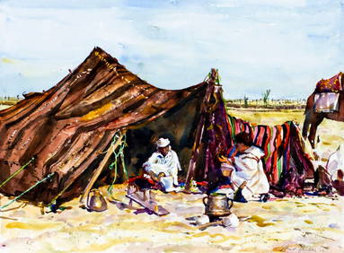
Sold2020d'Urville, Dumont 1839 Lot of 6 Prints. North AfricaIncl Morocco, Algeria and Tunisia. Etchings Published 1834 by Chez Furne et Ce, Paris for "Voyage pittoresque autour du Monde - Résumé général des voyages de découvertes..." By Jules Dumont d'UrvSee Sold Price
Sold2021North Africa Nations Stamp CollectionNorth Africa Nations stamp collection. This collection contains 1 and a half double-sided sheets. Countries included are Morocco, Algeria, Mauritania and Tunisia. Please see photos.See Sold Price
Sold20231892 Black Map of Africa [on Separate Sheet] Morocco, Algeria to Tunisia [on Separate Sheet] EgyptTitle: 1892 Black Map of Africa [on Separate Sheet] Morocco, Algeria to Tunisia [on Separate Sheet] Egypt Cartographer: A&C Black Year / Place: 1892, Edinburgh Map Dimension (in.): 21.3 X 16.8 in. LarSee Sold Price
Sold2024Turkey In Europe after the Treaty of Berlin. Balkans. HUGHES 1876 old mapTITLE/CONTENT OF MAP: 'Turkey In Europe after the Treaty of Berlin' DATE PRINTED: 1876 IMAGE SIZE: Approx 25.0 x 30.0cm, 9.75 x 11.75 inches (Large) TYPE: Antique hand coloured engraved map CONDITION:See Sold Price
Sold2024NORTH EAST AFRICA. Libya Egypt Sudan Ethiopia Ubangi-Shari Chad 1952 old mapCAPTION PRINTED BELOW PICTURE: 'Africa, North-East' DATE PRINTED: 1952 IMAGE SIZE: Approx 34.0 x 44.0cm, 13.5 x 17.25 inches (Large); Please note that this is a folding map. TYPE: Vintage colour map;See Sold Price
Sold2023NORTH EAST AFRICA. Libya Egypt Sudan Ethiopia Ubangi-Shari Chad 1952 old mapTITLE/CONTENT OF MAP: 'Africa, North-East' DATE PRINTED: 1952 IMAGE SIZE: Approx 34.0 x 44.0cm, 13.5 x 17.25 inches (Large); Please note that this is a folding map. TYPE: Vintage colour map; Scale 1:1See Sold Price
Sold2023NORTH AFRICA BARBARY. Tripoli Libya Egypt coast Alexandria Tobruk. SDUK 1874 mapTITLE/CONTENT OF MAP: 'NORTH AFRICA OR BARBARY, V., PARTS OF TRIPOLI AND EGYPT' DATE PRINTED: 1874 IMAGE SIZE: Approx 34.0 x 42.5cm, 13.25 x 16.75 inches (Large) TYPE: Antique steel engraved map withSee Sold Price
Sold2018Old Berber Leather hand bag fascinating embellishmentsThis is a beautiful antique leather satchel or hand bag from Morocco , North Africa. This hand bag was created and used by the Berber peoples and shows years of embellishments and decorative additionsSee Sold Price
Sold2018Old Berber Leather hand bag with fascinating adornmentThis is a beautiful antique leather satchel or hand bag from Morocco , North Africa. This hand bag was created and used by the Berber peoples and shows years of embellishments and decorative additionsSee Sold Price
Sold2024NORTH AFRICAN FLAGS. Tripoli Tunis Algiers. Libya Tunisia Algeria. HOUNSELL 1873CAPTION PRINTED BELOW PICTURE: '156. Tripoli, Tripoli; 157. Tunis, Tunis; 158. Algiers,Alger, Alger' DATE PRINTED: 1873 IMAGE SIZE: Approx 26.0 x 42.0cm, 10 x 16.5 inches (Large) TYPE: Antique chromolSee Sold Price
Sold202117th C. French Engraving Map of N. Africa MoroccoFrench hand-colored engraving of North Africa, including Morrocco, parts of Algeria, Strait of Gibraltar. Dated 1655. Measures 16"H x 21"W visual image , 23.75"H x 27.75"W framed. Condition report: GoSee Sold Price
Sold2023MAP, Africa, MercatorNorthwestern Africa. Mercator/Hondius, Fessae Regnum, from Atlas Minor, 1609 (published). Hand Color. This charming small map of Morocco and Algeria extends south to Beninia and Nussini and includes tSee Sold Price
Sold2019Beni Mguild Pile RugFirst quarter 20th century, 380 x 170 cm, North Africa, Morocco, Middle Atlas Rather than a monochrome surface, the open field of this large Berber carpet presents the sum of various shades of crimsonSee Sold Price
Sold2021Rare Fossilized Rugops Raptor Killing Claw - Large!North Africa, Morocco, Kem Kem Formation, Middle Cretaceous Period, ca. 98 to 93 million years ago. An amazing, fossilized raptor claw, possibly from the Rugops genus of dinosaurs, a rare species thatSee Sold Price
23 hrs LeftAlbion AuctionsClarke & Russell 1814 Hand Col Map. Canada - British Dominions in North America$25(3 bids)
3 days LeftBroward Auction GalleryATTR Elliott Daingerfield (NY,NC,1859-1932) oil painting antique$475(3 bids)
3 days LeftBroward Auction GalleryJames William Whittaker (UK,1828-1876) oil painting antique$140(3 bids)
3 days LeftUkiyoe Gallery Japanese Woodblock PrintsYoshida Hiroshi: Soshu 1940 JIZURI Woodblock$2,250(5 bids)
Jun 02Broward Auction GalleryFrederick Albert Slocombe (UK,1847-1920) oil painting antique$200(3 bids)


![South America north west. Peru Bolivia Ecuador Columbia. HUGHES 1876 old map: Title: South America north west. Peru Bolivia Ecuador Columbia. HUGHES 1876 old map Description: [South America north west] by William Hughes (1876). Antique hand coloured engraved map, 30.0 x 24.5cm,](https://p1.liveauctioneers.com/5584/299901/159842110_1_x.jpg?height=310&quality=70&version=1693338270)


![1892 Black Map of Africa [on Separate Sheet] Morocco, Algeria to Tunisia [on Separate Sheet] Egypt: Title: 1892 Black Map of Africa [on Separate Sheet] Morocco, Algeria to Tunisia [on Separate Sheet] Egypt Cartographer: A&C Black Year / Place: 1892, Edinburgh Map Dimension (in.): 21.3 X 16.8 in. Lar](https://p1.liveauctioneers.com/5584/279105/146836151_1_x.jpg?height=310&quality=70&version=1677020518)