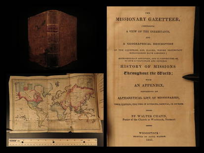
Sold20211825 1ed Missionary Gazetteer Chapin Slavery Indians1825 1ed Missionary Gazetteer Chapin Slavery Indians Illustrated Color World MAP ‘Missionary Gazetteer’ is a general history of missions throughout the world arranged alphabetically with an appendSee Sold Price
Sold2022Swire, William 1825 Large Canal & River Map of the UK"Map of the Canals and Navigable Rivers in England, Wales and Scotland" Copper Engraved Map Published 1824-25, Liverpool for "History, Directory, and Gazetteer, of the County Palatine of Lancaster" bySee Sold Price
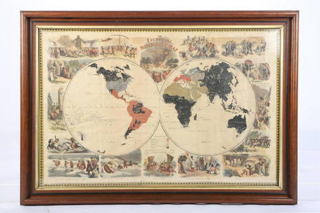
Sold2021PICTORIAL MISSIONARY MAP OF THE WORLDHand colored lithograph featuring map of the globe with vignettes of the introduction of Christianity in various cultures of the world, published in 1861, sight size 18 3/4 x 28 3/4 inches, set in oriSee Sold Price
Sold20221762 Brookes The General Gazetteer MapsTitle: 1762 Brookes The General Gazetteer Maps Description: "The General Gazetteer: or, Compendious Geographical Dictionary. Containing a description of all the empires, Kingdoms, States, RepublicsSee Sold Price
Sold20232 Malham's Naval Gazetteer MapsTwo early 19th century Malham's Naval Gazetteer engraved maps with hand-coloring. Includes "A Correct Chart of the West Indes" and "A Correct Chart of the Coasts of South America". Both dated "1801" uSee Sold Price
Sold20191825 Buchon Map of Alabama -- Carte Geographique,Title/Content of Map: 1825 Buchon Map of Alabama -- Carte Geographique, Statistique et Historique d' Alabama Cartographer: J Buchon / Carey & Lea Size: 18.1 x 24 in. This early map of Alabama is fromSee Sold Price
Sold2019United States from The Latest AuthoritiesTitle: United States from The Latest Authorities Date: 1853 Cartographer: HAYWARD'S GAZATTEER Publisher: HAYWARD'S GAZETTEER Size: 21.5Height - 39.5Width HAYWARD'S GAZATTEER HAYWARD'S GAZETTEER Map onSee Sold Price
Sold20201825 Vandermaelen Map of the Lesser Antilles -- Amer.Title/Content of Map: 1825 Vandermaelen Map of the Lesser Antilles -- Amer. Sep. Petites Antilles No. 65. Cartographer: P Vandermaelen Year/Place: 1825-7, Paris Size: 18 X 21.1 in. This is a detailed,See Sold Price
2018Buchon: Antique Map of New York, 1825Title/Content of Map: 1825 Buchon Map of New York -- Carte Geographique, Statistique et Historique Du New-York Date Printed: 1825, Paris Cartographer: J A Buchon Size: 16 x 24 in. This quite attractivSee Sold Price
Sold20201825 Buchon Map of New York -- Carte Geographique,Title/Content of Map: 1825 Buchon Map of New York -- Carte Geographique, Statistique et Historique Du New-York Cartographer: J A Buchon Year/Place: 1825, Paris Size: 16 x 24 in. This quite attractiveSee Sold Price
Sold2021Courtier, Henry 1890 Biblical Atlas, 12 Maps"Biblical Atlas and Scripture Gazetteer" Maps by Henry Courtier. London: The Religious Tract Society, 1890. Complete with 12 Color Lithograph Maps of the Holy Land. Brown Cloth with Gilt Title. SpineSee Sold Price
Sold20231854 Baldwin Gazetteer w/stunning mapA New and Complete Gazetteer of the United States; Giving a Full and Comprehensive Review of the Present Condition, Industry, and Resources of the American Confederacy by Thomas Baldwin and J. Thomas.See Sold Price
Sold20231810 American Gazetteer ATLAS Map Georgia Native Americans RARE Jedidiah Morse1810 American Gazetteer ATLAS Map Georgia Native Americans RARE Jedidiah Morse Jedidiah Morse was an important and prominent geographer known for his American textbooks, books that earned him the nameSee Sold Price
Sold20201798 American Gazetteer ATLAS Map Georgia Indians1798 American Gazetteer ATLAS Map Georgia Native Americans RARE Jedidiah Morse Jedidiah Morse was an important and prominent geographer known for his American textbooks, books that earned him the nameSee Sold Price
Sold2017Darby's Gazetteer with map of Easter US 1827Heading: Author: Darby, William Title: Darby's Universal Gazetteer... Illustrated by a neat coloured map of the United States Place Published: Philadelphia Publisher:Bennett & Walton Date PublisSee Sold Price
Sold2017Haity. Ile St-domingue Unified Map, Buchon, 1825TITLE/CONTENT OF MAP: 'Carte géographique, statistique et historique de Haity. Ile St-Domingue' The island of Hispaniola is shown as undivided, having been unified under the Haitian government sinceSee Sold Price
Sold2023Thomson, John (Pub) 1825 Map. AustraliaCopper Engraved Map Published 1825 by John Thomson, Edinburgh for "The Edinburgh School Atlas" by N. R. Hewitt. Maps Engraved by Hewitt. Original Outline Hand Colour. Rare. Paper Size: 10.5 x 8 inch (See Sold Price
Sold2023L'Amérique méridionale'.South America newly independent states. BUCHON 1825 mapTitle: L'Amérique méridionale'.South America newly independent states. BUCHON 1825 map Description: Carte géographique, statistique et historique de l'Amérique méridionale' by Jean AlexSee Sold Price
Sold2021Thomson, John (Pub) 1825 Map. AfricaCopper Engraved Map Published 1825 by John Thomson, Edinburgh for "The Edinburgh School Atlas" by N. R. Hewitt. Maps Engraved by Hewitt. Engraved Vignette in corner. Original Outline Hand Colour. RareSee Sold Price
Sold2023Thomson, John (Pub) 1825 Map. United States of AmericaCopper Engraved Map Published 1825 by John Thomson, Edinburgh for "The Edinburgh School Atlas" by N. R. Hewitt. Maps Engraved by Hewitt. Original Outline Hand Colour. Rare. Paper Size: 10.5 x 8 inch (See Sold Price
Sold2023Thomson, John (Pub) 1825 Map. West Indies CaribbeanCopper Engraved Map Published 1825 by John Thomson, Edinburgh for "The Edinburgh School Atlas" by N. R. Hewitt. Maps Engraved by Hewitt. Original Outline Hand Colour. Rare. Paper Size: 10.5 x 8 inch (See Sold Price
Sold2023Thomson, John (Pub) 1825 Map. North AmericaCopper Engraved Map Published 1825 by John Thomson, Edinburgh for "The Edinburgh School Atlas" by N. R. Hewitt. Maps Engraved by Hewitt. Original Outline Hand Colour. Rare. Paper Size: 10.5 x 8 inch (See Sold Price
Sold2023Thomson, John (Pub) 1825 Map. Polar Regions. Canada GreenlandCopper Engraved Map Published 1825 by John Thomson, Edinburgh for "The Edinburgh School Atlas" by N. R. Hewitt. Maps Engraved by Hewitt. Original Outline Hand Colour. Rare. Paper Size: 10.5 x 8 inch (See Sold Price
Sold2021Thomson, John (Pub) 1825 Map. IrelandCopper Engraved Map Published 1825 by John Thomson, Edinburgh for "The Edinburgh School Atlas" by N. R. Hewitt. Maps Engraved by Hewitt. Engraved Vignette in corner. Original Outline Hand Colour. RareSee Sold Price
Jun 23Schilb Antiquarian Rare Books1890 Livingstone 1ed In Darkest Africa Henry Stanley Emin Pasha Expedition MAP$115(8 bids)
Featured1 day LeftJasper521831 Woodbridge Map of South America and Africa -- Comparative, Geographical & Statistical Map of$70(1 bid)
Jun 15Riverfront Auctions'1785 Bocage Map of the City of Athens in Ancient Greece' Par M. Barbié du Bocage$5(1 bid)
Jun 23Treasure Quest AuctionsPr. Child's Ulster County, NY 1871-72 Gazetteer & Business Directories$50
2 days LeftJasper52NORTH AFRICA OF BABRBARY V Parts of Tripoli & Egypt. Libya Tribes. SDUK 1846 map$15
2 days LeftJasper52NORTH AFRICA OF BABRBARY V Parts of Tripoli & Egypt. Libya Tribes. SDUK 1851 map$20
4 days LeftFreeman's | HindmanHOMANN, Johann Baptist. Amplissimae Regionis Mississipi Seu Provinciae Ludovicianae. Nuremburg, [ca$425(2 bids)
3 days LeftHolabird Western Americana CollectionsTravels in the Interior of Mexico, 1829 [181927]$100
3 days LeftHolabird Western Americana CollectionsJesuit Monk Father Kino Research Library (9) 1919-92 [182271]$200
BonhamsLATROBE (CHRISTIAN IGNATIUS) Journal of a Visit to South Africa, in 1815, and 1816. With some ac...£300
BonhamsEAST AFRICA DE WIT (FREDERICK) Occidentalior Tractus Indiarum Orientalium a Promontorio Bonae Sp...£300
BonhamsLONDON MAITLAND (WILLIAM) The History of London from its Foundation to the Present Time, J. Wil...£600


![Travels in the Interior of Mexico, 1829 [181927] (1 of 7)](https://p1.liveauctioneers.com/2699/331494/178785494_1_x.jpg?height=282&quality=70&version=1717094654)

![Jesuit Monk Father Kino Research Library (9) 1919-92 [182271] (1 of 8)](https://p1.liveauctioneers.com/2699/331494/178785625_1_x.jpg?height=282&quality=70&version=1717094654)

![[Lockhart, John Gibson], (1 of 7)](https://p1.liveauctioneers.com/1782/331487/178781730_1_x.jpg?height=282&quality=70&version=1716992745)


