Sold2022ORTELIUS, ABRAHAM; and PHILILLPE GALLE. Set of 5 miniature maps of the world and continents.ORTELIUS, ABRAHAM; and PHILILLPE GALLE. Set of 5 miniature maps of the world and continents. Engravings with original hand-color. 4x5½ inches each sheet size, Latin text on verso; light finger soSee Sold Price
Sold2021Glass World Globe PaperweightClear glass globe with textured and shaded world map continents. Measures 3 x 3.25 in. Desktop items, Paper & table accessories, home accents and decor, Art glass paperweight, globe paperweight, worldSee Sold Price
Sold2020Framed Antique Map Orbis Vetus, Robert De VaugondyItem/Description: Old print. Map of the world by Robert de Vaugondy from 1752. Orbis vetus in utraque continente : In both the old continent / world map / Vaugondy 1752. Material: Print framed under gSee Sold Price
Sold2018Ortelius' 1570 world mapHeading: Author: Ortelius, Abraham Title: Typus Orbis Terrarum Place Published: Antwerp Publisher: Date Published: 1570-[1584?] Description: Copper-engraved map, hand-colorSee Sold Price
Sold2016Celebrated 16th Century World Map by Abraham OrteliusTypvs Orbis Terrarvum, Antwerp, dated 1587, with hand-coloring; Spanish text on the back credits the cartographer's sources in this updated edition showing the Solomon Islands and a corrected South AmSee Sold Price
Sold2022Curtis Jere, Pair of Earth Globe Mid Century WallCurtis Jere, pair of mid century modern wall art sculptures, globe form map of the world, featuring the continents with topography features. Approximately 19.9375W x 2.125H in.See Sold Price
Sold2023Assorted Maps on Europe & the Sub ContinentAssorted maps on Europe, Scandinavia, and the Sub Continent, including Celestial and World Maps, some old and hand colored, some modern and picture reproductions. Provenance: Phyllis Lucas Gallery, NYSee Sold Price
Sold2017Ortelius: Antique Map of the World, 1587Map: World Date Printed: 1587-1612 Cartographer: Abraham Ortelius Material/Medium: Paper Size: *** Approx 16" x 21" Original hand color. Copperplate engraved.One of the most famous and iconic world maSee Sold Price
Sold2022Anthony Finley’s 1833 map of The WorldLovely example of Finley's attractive The World on Mercator's Projection, from his 1833 New General Atlas. The world’s continents are shown in clear detail, with many rivers, cities, coastal feaSee Sold Price
Sold2023OVERSIZED REPRODUCTION OF A 16TH C. MAPMonumental and highly decorative offset lithograph reproduction map of the world by Giovanni Marfei after Abraham Ortelius, originally published c. 1589 or 1593. Dimensions: (Frame) H 45" x W 84" CondSee Sold Price
Sold2022World.- Bordone (Benedetto di) [World Map], woodcut, [1522].World.- Bordone (Benedetto di) [World Map], early map showing the recent developments in cartography and departing from Ptolemaic models, including open water between the two continents and not joininSee Sold Price
Sold2022Africa.- Ortelius (Abraham) Africae Tabula Nova, engraved map, [c.1570-1612].Africa.- Ortelius (Abraham) Africae Tabula Nova, detailed map of Africa based upon Gastaldi's 8 sheet wall map and Mercator's world map of 1569, decorated with a strapwork title cartouche, a sea battlSee Sold Price
Sold2022Wells' world map with California an Island 1700Heading: Author: Wells, Edward Title: A New Map of the Terraqueous Globe according to the Ancient Discoveries and most general Divisions of it into Continents and Oceans Place Published: London PubliSee Sold Price
Sold2023World Map by Ceramiche Zaccacnini, set as Coffee TableLot 133 World Map by Ceramiche Zaccacnini, set as Coffee Table map of the world, centered on the Atlantic Ocean and surrounding continents 19 x 36 x 20 1/2 inches Provenance: Property from the CollecSee Sold Price
Sold2022Buffon & Tardieu 1853 Map. Ancient World"Carte de l'Ancien Continent" Steel Engraved Map with outline hand color Published 1853-55, Paris for "Oeuvres Completes de Buffon" by the Comte de Buffon. Engraved by Ambroise Tardieu. Paper Size: 10See Sold Price
Sold2022Buffon & Tardieu 1853 Map. New World"Carte de Nouveau Continent" Steel Engraved Map with outline hand color Published 1853-55, Paris for "Oeuvres Completes de Buffon" by the Comte de Buffon. Engraved by Ambroise Tardieu. Paper Size: 10See Sold Price
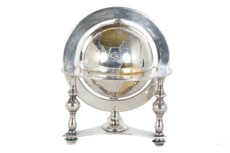
Sold2023Bulgari Sterling Silver & Vermeil Table Globe 805gA Bulgari Italian sterling silver table globe sculpture. Classical style design with spinning world map globe set within a round tri legged ring stand. Map continents finished in gold vermeil, and surSee Sold Price
Sold2016The World On Mercator's Projection, 1829Map: The World On Mercator's Projection Maker: Anthony Finley Date: 1829 Size: Quarto, 8.9 inches high x 11.10 inches wide Details the world centered on the Pacific Ocean. Shows continents, countries,See Sold Price
Sold2022Glass Lamp Globe, Imprinted Map of the WorldAmber glass lamp globe, with raised continents showing a map of the world. Handblown into a two piece mold. From Columbian Exposition 1893 Chicago World’s Fair; One likely hung in the electriciSee Sold Price
Sold2019Bartholomew, John 1922 Group of 3 Maps of AfricaIncl Africa Continent, North Africa and West Africa. Large Lithograph Maps Published 1922 by The Times, London for "The Times Survey Atlas of the World" Maps by John George Bartholomew of the EdinburgSee Sold Price
Sold2022ORTELIUS, ABRAHAM. Typus Orbis Terrarum.ORTELIUS, ABRAHAM. Typus Orbis Terrarum. Double-page engraved map of the world. 16¾x20½ inches sheet size, wide margins, Dutch text on verso; original hand-color; professionally conserved wiSee Sold Price
Sold2021ORTELIUS, ABRAHAM. [Globus Terrestris.]ORTELIUS, ABRAHAM. [Globus Terrestris.] Miniature hand-colored engraved double-hemispheric map of the world with a charming topographical landscape below and sky above, from Epitome Theatri Orteliani.See Sold Price
Sold2024Abraham Ortelius Map Of WalesOrtelius' map is the first printed map of Wales, appeared in Ortelius' Theatrum Orbis Terrarum, the first modern atlas of the world. The map is based upon Mercator's 1564 wall map of the British IslesSee Sold Price
Sold2017Mallet: Antique Map of the World; France, 1683Map Title: 'Planisphere du Monde; France' FRANCE/WORLD. odd-shaped Australia close to southern continent. Date Printed: 1683 Image Size: Approx Overall page size 13 x 21cm approximately (5 x 8 inches)See Sold Price
5 days LeftJasper521881 Vuillemin World Map with French Colonies Shown -- Planisphere: Indiquant les Colonies Francises$30
2 days LeftTrillium Antique Prints & Rare BooksBraun & Hogenberg, pub. 1575 - View of Ostia, Italy$140(2 bids)
2 days LeftTrillium Antique Prints & Rare BooksBraun & Hogenberg, pub. 1575 - Views in the Middle East: Aden, Mombasa, Kilwa, & Sofala$100(1 bid)
2 days LeftTrillium Antique Prints & Rare BooksBraun & Hogenberg, pub. 1575 - View of Delft, Netherlands$100
2 days LeftTrillium Antique Prints & Rare BooksBraun & Hogenberg, pub. 1575 - View of Alexandria, Egypt$100(1 bid)
2 days LeftTrillium Antique Prints & Rare BooksBraun & Hogenberg, pub. 1575 - View of Lyon, France$100
2 days LeftTrillium Antique Prints & Rare BooksBraun & Hogenberg, pub. 1575 - View of Chester, England$100
5 days LeftJasper521833 Woodbridge World Map -- Map of the World Adapted to Woodbridge's Geography$40
Jun 07Freeman's | Hindman[MAP]. ORTELIUS, Abraham. Americae Sive Novi Orbis, Nova Descriptio. 1573.$1,000(1 bid)
Jun 07Freeman's | Hindman[MAPS]. ORTELIUS, Abraham. A group of 3 engraved maps with hand-coloring.$175(2 bids)
5 days LeftJasper521581 Ortelius Map of Tuscany [with] Corsica [with] Ancona -- Senensis Ditionis, Accurata Descrip [on$140


![Ortelius' 1570 world map: Heading: Author: Ortelius, Abraham Title: Typus Orbis Terrarum Place Published: Antwerp Publisher: Date Published: 1570-[1584?] Description: Copper-engraved map, hand-color](https://p1.liveauctioneers.com/642/127929/65081054_1_x.jpg?height=310&quality=70&version=1537227236)


![World.- Bordone (Benedetto di) [World Map], woodcut, [1522].: World.- Bordone (Benedetto di) [World Map], early map showing the recent developments in cartography and departing from Ptolemaic models, including open water between the two continents and not joinin](https://p1.liveauctioneers.com/5458/252576/131355887_1_x.jpg?height=310&quality=70&version=1655911671)
![Africa.- Ortelius (Abraham) Africae Tabula Nova, engraved map, [c.1570-1612].: Africa.- Ortelius (Abraham) Africae Tabula Nova, detailed map of Africa based upon Gastaldi's 8 sheet wall map and Mercator's world map of 1569, decorated with a strapwork title cartouche, a sea battl](https://p1.liveauctioneers.com/5458/269991/141255679_1_x.jpg?height=310&quality=70&version=1669303305)


![ORTELIUS, ABRAHAM. [Globus Terrestris.]: ORTELIUS, ABRAHAM. [Globus Terrestris.] Miniature hand-colored engraved double-hemispheric map of the world with a charming topographical landscape below and sky above, from Epitome Theatri Orteliani.](https://p1.liveauctioneers.com/199/226915/117192072_1_x.jpg?height=310&quality=70&version=1637249113)


![[MAP]. ORTELIUS, Abraham. Aevi Veteris, Typus Geographicus. 1601. (1 of 3)](https://p1.liveauctioneers.com/197/329395/177650532_1_x.jpg?height=282&quality=70&version=1715364962)


![[MAP]. ORTELIUS, Abraham. Africae Tabula Nova. 1592. (1 of 2)](https://p1.liveauctioneers.com/197/329395/177650533_1_x.jpg?height=282&quality=70&version=1715364962)
![[MAP]. ORTELIUS, Abraham. Americae Sive Novi Orbis, Nova Descriptio. 1573. (1 of 2)](https://p1.liveauctioneers.com/197/329395/177650534_1_x.jpg?height=282&quality=70&version=1715364962)
![[MAP]. ORTELIUS, Abraham. Romani Imperii Imago. 1592. (1 of 2)](https://p1.liveauctioneers.com/197/329395/177650537_1_x.jpg?height=282&quality=70&version=1715364962)
![[MAP]. ORTELIUS, Abraham. Turcici Imperii Descriptio.1592. (1 of 2)](https://p1.liveauctioneers.com/197/329395/177650538_1_x.jpg?height=282&quality=70&version=1715364962)
![[MAPS]. ORTELIUS, Abraham. A group of 3 engraved maps with hand-coloring. (1 of 4)](https://p1.liveauctioneers.com/197/329395/177650539_1_x.jpg?height=282&quality=70&version=1715364962)


![1581 Ortelius Map of Tuscany [with] Corsica [with] Ancona -- Senensis Ditionis, Accurata Descrip [on (1 of 1)](https://p1.liveauctioneers.com/5584/331064/178466435_1_x.jpg?height=282&quality=70&version=1716924723)


