Sold2023Lot of antique books - 1761, 1764Lot of antique books (1761, 1764) Description: Includes Abbé Batteux, Principes de la littérature, tomes III, IV, V, Paris 1764; Jousse, Daniel, Nouveau commentaire sur les ordonances...See Sold Price
Sold2017Dictionnaire de Chirurgie, 1767Heading: Author: [Levacher de La Feutrie, A.F. Thomas, et al.] Title: Dictionnaire de Chirurgie Place Published: Paris Publisher:Chez Lacombe Date Published: 1767 Description:See Sold Price
Sold2018Map of the Society Islands, 1787Heading: Author: Bonne, Rigobert Title: Carte des Isles de la Societé Place Published: Paris Publisher: Date Published: 1787 Description: Copper-engraved map, later hand-coSee Sold Price
Sold2015Le Style Moderne; Contribution de la FranceHeading: Author: Van de Velde, Henry, introduction Title: Le Style Moderne; Contribution de la France Place Published: Paris Publisher:Librairie des Arts Decoratifs Date Published: [1925]See Sold Price
Sold2024MAPS, Caucasus, ChatelainCaucasus. Henry Abraham Chatelain, [Lot of 2] Vue et Description des Principales Villes de l'Armenie et de la Georgie... [and] Mariage des Turcs & des Armeniens avec la Maniere dont se Font les DemonsSee Sold Price
Sold20211838 Italy MapAuthor: Delamarche Title: 1838 Italy Map Medium: Ink on Paper Dimensions: 13"X19" Description: Italy map dated 1838. Engraved by Delamarche. Part of Atlas de la Geographie. Published in Paris. CopperSee Sold Price
Sold2018Boisseau: Crete with Aegean Island InsetsReserve Reduced! Map Title: Description de l'isle de Candie et des isles Voisine sde la Grece Cartographer: Boisseau Place/Date: Paris / 1645 Size: 18 1/2" x 12 3/4" Condition: outline color; two smalSee Sold Price
Sold2018Chatelain: Alexandria, Egypt, and its AntiquitiesReserve Reduced! Map Title: Description de la Ville d'Alexandrie et des Antiquites Remarquables qu'on y voit Cartographer: Chatelain Place/Date: Amsterdam / 1719 Size: 19" x 14 1/2" Condition: b&w; ovSee Sold Price
Sold20241812 large French map of Paris plan routier de la Ville et faubourgLarge engraving of Paris and its surrounding area dated 1812 , cooper engraving in the manner of the Turgot map ,Jean Pierre printer , a Paris, chez Jean, Rue St Jean de Beauvais, N° 10, It is thSee Sold Price
Sold2022James Jacques TISSOT: "The Green Room"James Jacques TISSOT (1836-1902): "The Green Room of the Theatre Francais (Memory of the Siege of Paris)" / "Le Foyer de la Comédie-Français pendant le siege de Paris" (original French title). ESee Sold Price
Sold2017Chatelain: Antique Maps/Views Mexico City & EnvironsMap: Description, Situations et Vue de la Ville de Mexique, des deux lacs sur lesquels elle est batie, du grand temple de cette ville, des sacrifices d'Hommes qu'on y faisoit, de l'Idole des MexicainsSee Sold Price
Sold2018Mallet, Alain Manesson 1683 HCol Map of India & China"Ancienne Region des Sines" Hand Coloured Copper Engraved Map Published 1683, Paris for "Description de l'Univers" by Alain Manesson Mallet. French text to verso. Paper Size: 8 x 5 inch (20 x 13cm) GoSee Sold Price
Sold2021Mallet, Alain 1683 Antique Map. Ancient Libya"Ancienne Libye Interievre" Copper Engraved Map Published 1683, Paris for "Description de l'Univers" First Edition by Alain Manesson Mallet. French text to verso. Paper Size: 8 x 5 inch (20 x 13cm) SoSee Sold Price
Sold2019Mallet, Alain 1683 Map of Germany & Part of Poland"Allemagne en General" Copper Engraved Map Published 1683, Paris for "Description de l'Univers" by Alain Manesson Mallet. French text to verso. Paper Size: 8 x 5 inch (20 x 13cm) Good ConditionSee Sold Price
Sold2018Mallet, Alain 1683 HC Map of Turkey in Asia, Black Sea"Turquie en Asie" Hand Coloured Copper Engraved Map Published 1683, Paris for "Description de l'Univers" by Alain Manesson Mallet. French text to verso. Paper Size: 8 x 5 inch (20 x 13cm) Good ConditiSee Sold Price
Sold2019Mallet, Alain 1683 Map of France & Europe"Cerle de Bourgogne" Copper Engraved Map Published 1683, Paris for "Description de l'Univers" by Alain Manesson Mallet. French text to verso. Paper Size: 8 x 5 inch (20 x 13cm) Good ConditionSee Sold Price
Sold2019Mallet, Alain 1683 Map of Lorraine, FranceCopper Engraved Map Published 1683, Paris for "Description de l'Univers" by Alain Manesson Mallet. French text to verso. Paper Size: 8 x 5 inch (20 x 13cm) Good ConditionSee Sold Price
Sold2018Mallet, Alain 1683 HC Map of Terki Fort Russia Caucasus"Tekcki" Hand Coloured Copper Engraved Map Published 1683, Paris for "Description de l'Univers" by Alain Manesson Mallet. French text to verso. Paper Size: 8 x 5 inch (20 x 13cm) Good ConditionSee Sold Price
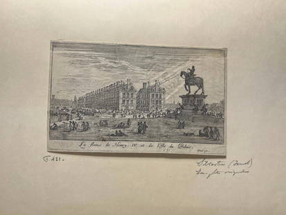
Sold2024'La statue de Henry IV et l'Isle du Palais' Copperplate Engraving, c. 1621France, 17th century. A copperplate engraving by Israel Silvestre (1621-1691). On lined paper with a watermark, partially of a heart. Exact copies held by the Royal Collection Trust and the Louvre. MSee Sold Price
Sold2023JAMES JACQUES JOSEPH TISSOT (FRENCH 1836-1906), LE FOYER DE LA COMÉDIE-FRANÇAISEJAMES JACQUES JOSEPH TISSOT (FRENCH 1836-1906) LE FOYER DE LA COMÉDIE-FRANÇAISE PENDANT LA SIEGE DE PARIS (WENTWORTH 27) Etching, 1877, from the edition of circa 100Sheet 38 x 28cm (15 x 11iSee Sold Price
Sold2019Delamarche, Felix 1829 Pair of Maps. Roman Empire etc"Orbis Antiqui Mappa Nova" and "Imperii Romani Tabula" Copper Engraved Maps Published 1829, Paris for "Atlas de La Geographie..." by Felix Delamarche. Contemporary outline hand colour. Centre fold asSee Sold Price
Sold2019Delamarche, Felix 1829 Group of 3 Maps of Italy"Royaumes de Naples Sicile et Sardaigne" "Italiae Antiquae Mappa Nova" and "Italie Septentrionale" Copper Engraved Map Published 1829, Paris for "Atlas de La Geographie..." by Felix Delamarche. ContemSee Sold Price
Sold2019Cortambert, Eugene 1874 Group of 3 HC French MapsHand Coloured Lithograph Maps Published 1874, Paris for "Atlas de la Geographie de L'Europe" by Eugene Cortambert. Paper Size: 13.5 x 10 inch (34 x 26cm) Good ConditionSee Sold Price
Sold2019Delamarche, Felix 1829 Lot of 6 Ancient Europe MapsIncl Ancient France, Spain, Germany, Greece, Alexander the Great Empire, and Asia Minor. Copper Engraved Maps Published 1829, Paris for "Atlas de La Geographie..." by Felix Delamarche. Contemporary ouSee Sold Price
3 days LeftAkiba Galleries1895 Spanish Diccionario Enciclopedico De La Lengua Castellana, 2 Volumes$50
3 days LeftAkiba Galleries(8 Pc) Ediciones Siglo Veinte "Las Grandes Revoluciones De La Historia" Book Series$50
3 days LeftJasper521804 TRAVELS of Ledyard & Lucas in Africa antique w/ MAPS Voyages de MM. Lédyard$240


![[MAPS]. [1590 Siege of Paris by Henry IV] Description de la... First Image](https://p1.liveauctioneers.com/928/323637/174189620_1_x.jpg?height=300&quality=1&version=1711128397&width=300)
![[MAPS]. [1590 Siege of Paris by Henry IV] Description de la... First Image](https://p1.liveauctioneers.com/928/323637/174189620_1_x.jpg?height=300&quality=95&version=1711128397&width=300)
![Dictionnaire de Chirurgie, 1767: Heading: Author: [Levacher de La Feutrie, A.F. Thomas, et al.] Title: Dictionnaire de Chirurgie Place Published: Paris Publisher:Chez Lacombe Date Published: 1767 Description:](https://p1.liveauctioneers.com/642/103227/52821786_1_x.jpg?height=310&quality=70&version=1493249074)

![Le Style Moderne; Contribution de la France: Heading: Author: Van de Velde, Henry, introduction Title: Le Style Moderne; Contribution de la France Place Published: Paris Publisher:Librairie des Arts Decoratifs Date Published: [1925]](https://p1.liveauctioneers.com/642/75369/39335469_1_x.jpg?height=310&quality=70&version=1437499334)
![MAPS, Caucasus, Chatelain: Caucasus. Henry Abraham Chatelain, [Lot of 2] Vue et Description des Principales Villes de l'Armenie et de la Georgie... [and] Mariage des Turcs & des Armeniens avec la Maniere dont se Font les Demons](https://p1.liveauctioneers.com/6576/320593/172252591_1_x.jpg?height=310&quality=70&version=1708729193)