Sold2020The Wonderground Map of London Town 1915 MacDonalLeslie MacDonald Gill (1884-1947), "The Wonderground Map of London Town," London, 1915. This highly detailed and eye-catching map was commissioned by the London Underground to entertain passengers waiSee Sold Price
Sold2022LONDON UNDERGROUND tube map diagram plan. First STINGEMORE edition 1925TITLE/CONTENT OF MAP: Underground Railways of London [694 11.5.25] This is the first edition of an Underground geographic map designed by F H Stingemore. It is one of the first designs not to show anySee Sold Price
Sold2018LONDON. Vintage Underground / Tube map 1933 old vintageTITLE/CONTENT OF MAP: 'Map of the Underground Railways of London' DATE: 1933 IMAGE SIZE: Approx 18.5 x 30.5cm, 7.25 x 12 inches (Medium) TYPE: Colour vintage street atlas map CONDITION: Good; suitableSee Sold Price
Sold2023Leslie MacDonald Gill (1884-1947) 'The Wonderground Map of London Town' c. 1924England, 20th century. Printed and Published by the Westminster Press, 11 Henrietta Street, Covent Garden, [1927]. Pictorial map printed in full color, 29” x 36.5” plus margins. The map waSee Sold Price
Sold2016MacDonald Gill (1884-1947) The County Bus Services MapMacDonald Gill (1884-1947) The County Bus Services Map and Central London Map, two reproductions of the original posters c.1922, printed for LT by John Bartholomew 1978 , each - 76 x 102 cm (2)See Sold Price
Sold2022London Tube Railways. 11 proposed new/extended Underground lines HMSO 1901 mapTITLE/CONTENT OF MAP: 'London tube railways 1901' This fascinating map, drafted by the Civil Engineer Sir Alexander Binnie in his capacity as Chief Engineer of London County Council, shows the developSee Sold Price
Sold2018CENTRAL LONDON TRANSPORT. Railways & underground tubeCENTRAL LONDON TRANSPORT. Railways & underground tube DATE: 1906 IMAGE SIZE: Approx 22.0 x 27.5cm, 8.5 x 10.75 inches (Medium); Please note that this is a folding map. TYPE: Antique colour travel mapSee Sold Price
Sold2023HAVANA. Vintage town plan. Railways & streetcar lines. Cuba. Caribbean 1923 mapHavana' by Sifton, Praed & Co. Ltd, St. James's St. London S.W. (1923). Vintage map, 18.5 x 15.0cm, 7.25 x 6 inches; Please note that this is a folding map. Additional Information: CAPTION PRINTED BELSee Sold Price
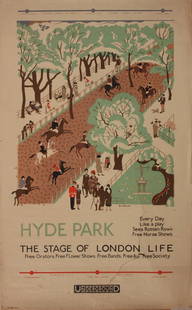
Sold2023Vintage PosterEdward Bawden (1903-1989) Hyde Park The Stage of London Life, original poster printed for the Underground (London Electric Railway) 1925 - 102 x 63 cm One the Bawden's first commercial design commissiSee Sold Price
Sold2017Cross (Joseph) - Cross's New Plan of London, 1836,from Canonbury to Camberwell, and from Hyde Park to East India Dock, updated to include the London and Birmingham railway, engraved map with full original hand-colouring, 665 x 1010mm., dissected andSee Sold Price
Sold2023Vintage PosterMacdonald Gill 1884-1947) The Country Bus Services Map, original poser printed for LT by Waterlow 1928 - 102 x127 cmSee Sold Price
Sold2015Original Vintage PosterT Way (Thomas Robert 1861-1914) Twickenham Ferry Underground London United Tramways , printed for Electric Railway House by T Way July 1911 - 52 x 21.5 cmSee Sold Price
Sold2022SOL LEWITT (1928-2007) R706 Map of London with the area between the underground stations at Marb...SOL LEWITT (1928-2007) R706 Map of London with the area between the underground stations at Marble Arch, St. James Park, Leicester Square, Waterloo Station, Pimlico, Sloane Sq., Knightsbridge, BayswatSee Sold Price
Sold2022Colefax and Fowler Mahogany and Linen Upholstered ClosetColefax and Fowler Mahogany and Linen Upholstered Closet </> With a brass fitted interior and an oak floor. 7 ft. 11 in. x 33 in. diam. </>Colefax & Fowler, London, January 2009. </>A Private ConnectiSee Sold Price
Sold2023Gothic Revival Metal-Mounted Oak Trestle Table with a Later Stone TopGothic Revival Metal-Mounted Oak Trestle Table with a Later Stone Top 28 x 5 ft. 3 in. x 21 3/4 in. Provenance: Guinevere, London, January 26, 2002. A Hamptons Interior Designed by Steven GambrelSee Sold Price
Sold2015Kingdom of IrelandJohn Speed (1552-1629). Engraved map. London: 1610 (1676). 17 1/4 x 22 inches. A rare, early printing of John Speed’s renowned map of Ireland. The map is decorated with a panel of costume figures deSee Sold Price
Sold2022Matched Pair of George III Style Mahogany Side Chairs, possibly ScottishMatched Pair of George III Style Mahogany Side Chairs, possibly Scottish </> 36 1/4 x 22 1/4 x 23 in., height of seat 18 in. </>Colefax and Fowler, London, January 2008. </>A Private Connecticut ColleSee Sold Price
Sold2021George V Sterling Silver Tea and Coffee Service, 6George V six-piece sterling silver tea and coffee service, Crichton Brothers (London), 1923, comprising of a hot water kettle on stand, teapot, coffeepot, creamer, sugar, and waste bowl, the bodies haSee Sold Price
Sold2022Faden Map of the Battle of Hobkirk's Kill, Revolutionary War, 1781FADEN, William (1749 – 1836). Sketch of the Battle of Hobkirks Hill, near Camden on the 25th April, 1781. Engraved map. London: Faden, Aug. 1, 1783. 21 3/4" x 15 1/8" sheet. This RevolutionarySee Sold Price
Sold2021English Sterling Silver Drinks TrayEnglish Sterling Silver Drinks Tray D&J Wellby Ltd., London, 1923 Rectangular with gadrooned border and loop handles. Length over handles 25 3/4 inches (65.5 cm), approximately 73 ounces. C Estate ofSee Sold Price
Sold2022Two English Silver Coffee Pots with Hinged CoversMark of Adie Bros., London, 1923; with wood handles. 9 1/4 x 8 x 4 1/4 in., 47.5 oz. approx. gross weight.See Sold Price
Sold2023LONDON MAP:LONDON MAP: LONDON MAP: Cary's New and Accurate Plan of London and Westminster, the Borough of Southwark and parts adjacent: viz. Kensington, Chelsea, Islington, Hackney, Walworth, Newington &c with aSee Sold Price
Sold2016A NEW MAP OF THE WHOLE CONTINENT OF AMERICA. EngravedA NEW MAP OF THE WHOLE CONTINENT OF AMERICA. Engraved and colored map. London, by Laurie & Whittle, May 1794. 101 x 118 cmSee Sold Price
Sold2022Art Deco 9ct Gold Cigarette Case,hallmarked London 1923 and by Joseph Walton & Co., 91.5 gSee Sold Price
2 days LeftForum AuctionsLondon.- River Thames.- Tombleson (William) Tombleson’s Panoramic Map of the River Thames and£260
1818 AuctioneersRailways and Engineering. Grover, J. W. - Estimates and Diagrams of Railway Bridges for Turnpike,£42
1818 AuctioneersPeriodical. The Yellow Book. An Illustrated Quarterly. London: John Lane, The Bodley Head. Volume£14
Jun 05TimeLine Auctions Ltd.Archaeological Books - Myths and Legends of Ancient Egypt and Other Titles.£5(1 bid)
1 day LeftDOYLE Auctioneers & AppraisersGeorge III Mahogany Miniature Bookcase Cabinet 19th Century$250
BonhamsA collected silver Hanoverian pattern table service of flatware various maker's and dates (Qty)£1,700(3 bids)
2 days LeftForum AuctionsLondon.- Langley (Edward, & Belch, William) Langley and Belch's New Map of London, engraved map,£600
BonhamsCORNELIS WILLAERTS (Dutch, 1600-1666) The Finding of Moses (framed 71.0 x 85.5 x 9.0 cm (28 x 33...$700(6 bids)
May 30PropstoreSTAR WARS: THE EMPIRE STRIKES BACK (1980) - Untrimmed UK "Gone with the Wind" Style A Quad£8,000
53 mins LeftBonhamsA group of six books and pamphlets, relating to the Sikh States of Patiala, Jind and Nabha Print...£1,200
Jun 06Freeman's | HindmanCLEMENS, Samuel Langhorne ("Mark Twain") (1835-1910). The Curious Republic of Gondour. New York:$200(1 bid)
2 days LeftPotter & Potter Auctions[HAND-COLORED AQUATINT]. [NELSON, Lord Horatio (1758-1805),...$250


![LONDON UNDERGROUND tube map diagram plan. First STINGEMORE edition 1925: TITLE/CONTENT OF MAP: Underground Railways of London [694 11.5.25] This is the first edition of an Underground geographic map designed by F H Stingemore. It is one of the first designs not to show any](https://p1.liveauctioneers.com/5584/263211/137236971_1_x.jpg?height=310&quality=70&version=1664917902)

![Leslie MacDonald Gill (1884-1947) 'The Wonderground Map of London Town' c. 1924: England, 20th century. Printed and Published by the Westminster Press, 11 Henrietta Street, Covent Garden, [1927]. Pictorial map printed in full color, 29” x 36.5” plus margins. The map wa](https://p1.liveauctioneers.com/7899/310285/166001628_1_x.jpg?height=310&quality=70&version=1700492487)


![[MAGIC & ALLIED ARTS]. Group of 8 volumes in original and d... (1 of 1)](https://p1.liveauctioneers.com/928/329228/177514409_1_x.jpg?height=282&quality=70&version=1715272280)
![[HAND-COLORED AQUATINT]. [NELSON, Lord Horatio (1758-1805),... (1 of 1)](https://p1.liveauctioneers.com/928/328184/176813390_1_x.jpg?height=282&quality=70&version=1714496988)
