Sold2020George F. Cram (1841-1928). Map of Texas, 1895George F. Cram (1841-1928). Map of the Eastern Half of Texas, Chicago /1895, Outline Color image size: 20.5 x 13.5", frame: 22 x 14.5"See Sold Price
Sold2019LARGE 1912 MAP, CITY OF AUSTIN, TEXAS, 73" x 44"Large faded unframed map, "Tobins Updated Map of the City of Austin, Mar. 1912", showing downtown blocks, the capitol building, East Avenue that became I35 and neighborhoods, 73.75"h, 44.5"w Start PriSee Sold Price
Sold2023Reproduction Revolutionary Map of Texas 1836Revolutionary Map of Texas 1836, reproduction, copyright 1987, framed sight: 31.5 x 26 in., frame: 44 x 38 in. Provenance: A collection in the Dominion, San Antonio, Texas We happily provide seamleSee Sold Price
Sold2022Clean 1883 RR map of Texas, Geo. F. CramInteresting cerographic map of Texas from Cram’s Unrivaled Family Atlas of the World. Predates subdivision of Tom Green, Pecos, Crockett and Presidio Counties. Shows rail system throughout statSee Sold Price
Sold2018Map of Texas Oil Drilling Sites"Gallup's Map of Texas, Published by F.E. Gallup Map Co." Sight size: 20-1/2"h x 29"w Provenance: Bought from rare book sealer in Santa Fe, New Mexico.See Sold Price
Sold2017Gray: Antique Map of Texas verso Arkansas, 1873Map: 1873 Gray's Map of Texas verso Arkansas -- Gray's Atlas Map of Texas; Gray's Atlas Map of Arkansas Cartographer: F Gray Year / Place: 1873, Philadelphia Map Dimensions: 11.8 X 15 in. Condition: VSee Sold Price
Sold2018Stephen F. Austin Life Like Wax HeadStephen F. Austin Life Like Wax Head. England: Gems of London, ca. 1960s. Well executed wax head of Stephen Austin, remembered in Texas history for his many efforts on behalf of the state before, duriSee Sold Price
Sold2024Stephen Austin Autographed Loan LetterStephen F. Austin autographed "TEXIAN LOAN" letter. He was the founder of the first American colony in Texas. Framed with print. Letter sight 9" x 8", frame overall 14" x 19".See Sold Price
Sold2020LBJ 1938 SIGNED ELISABET NEY 1905 STATUARY HALL BKBook: "Proceedings in the House of Representatives on the Occasion of the Reception and Acceptance from the State of Texas of the Statues of Sam Houston and Stephen F. Austin, February 25, 1905," forSee Sold Price
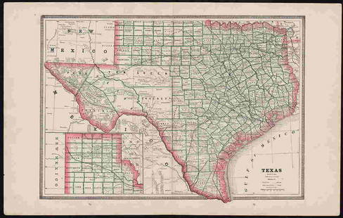
2017George Cram: Map of Texas, 1883Map: Texas Cartographer: George F. Cram Publisher: George F. Cram Co. Published: Chicago, 1883 Size: 11.75 x 17 inches Wonderful authentic antique map of Texas published in 1883 by George F. Cram. PriSee Sold Price
2021Bradford's Map of Texas 1835/36"Bradford's Map of Texas, 1st Separate Map of Texas to Appear in an Atlas" by Thomas G. Bradford, copper engraving with hand-colored outlines, published Boston, 1835/1836, together with accompanying aSee Sold Price
Sold2018Cram Map of TexasCRAM, George F (1842-1928). Railroad and county map of Texas. Lithograph with handcolor, with original black slipcase on the verso. Chicago, 1876. 17 3/4 x 24 inches sheet, 28 x 33 inches framedSee Sold Price
Sold20211880 Gray Map of Texas and Indian Territory -- Gray'sTitle: 1880 Gray Map of Texas and Indian Territory -- Gray's New Map of Texas and the Indian Territory Cartographer: F Gray Year/Place: 1880, Philadelphia Map Dimensions (in.): 17 X 26.4 in. DescriptiSee Sold Price
Sold2018Early 19th Century Map of LouisianaEarly 19th Century Map of Louisiana(Baltimore: F. Lucas, 1817), engraving with outline color, depicts adjacent areas in Mississippi, Alabama, Florida, Texas and Arkansas (being labeled "Missouri"). PrSee Sold Price
Sold2017JOHNSON'S MAP OF TEXAS, 1866Framed Johnson's Map of Texas, published by A.J. Johnson, New York, c. 1866, eastern counties defined, the panhandle void of listed settlements and listed as an area of the Comanche, sight: 17"h, 24"wSee Sold Price
Sold2020TEXAS MAP ENGRAVING PANHANDLE COUNTIES INSETFramed Texas map, hand-colored engraving on paper, a page from an atlas, plate 68, published by William Bradley, c.1880, an inset with Panhandle counties, within a geometric border, sight: approx 17.5See Sold Price
Sold20211869 McNally Map of Texas, Indian Territory and NewTitle: 1869 McNally Map of Texas, Indian Territory and New Mexico -- Texas, New Mexico, and Indian Territory Cartographer: F McNally Year / Place: 1869, New York Map Dimension (in.): 8.3 X 10.6 in. ThSee Sold Price
Sold20201890 Map of TexasAuthor: Gaskell Title: 1890 Map of Texas Medium: Ink on Paper Dimensions: 21.5"X13.5" Map of Texas dated 1890. This double folio map was part of Gaskell's Atlas of the World. Published by John F. WaitSee Sold Price
Sold2017Cram: Antique Map of Texas, 1887Title: Map of Texas by Cram Date: 1887 Medium: Wax Engraving Dimensions (in.): 14.5 x 22 George F. Cram (1842-1928) served in the U.S. Army during the American Civil War. After the war ended, Cram joiSee Sold Price
Sold2020FRAMED RANGER CANYON PRESS TEXAS WAGON TRAIL MAPFramed Texas Wagon Trail map, c.1986, signed John Davis (John Edward Davis, Texas, 1951-2008), published by Ranger Canyon Press, sight: approx 30.5"h, 25.5"w, overall: approx 32.75"h, 27.75"w, 8lbs StSee Sold Price
Sold20171852 S.A. MITCHELL MAP OF THE STATE OF TEXASFramed "Map of the State of Texas, Engraved to Illustrate Mitchell's School and Family Geography", 1852 by S.A. Mitchell (Samuel Augustus Mitchell, Philadelphia, 1790-1868), engraved by J.H. Young, haSee Sold Price
Sold20171846 S.A. MITCHELL MAP OF THE STATE OF TEXASFramed "Map of the State of Texas, Engraved to Illustrate Mitchell's School and Family Geography", 1846 by S. Augustus Mitchell (Samuel Augustus Mitchell, Philadelphia, 1790-1868), with notations in aSee Sold Price
Sold2017MAP, C. 1842, CENTRAL AMERICA, TEXAS, CALIFORNIAFramed map c. 1842, "Central America including Texas, California and the Northern States of Mexico", "Published under the Superintendence of the Society for Diffusion of Useful Knowledge", J&C Walker,See Sold Price
Sold20171835 MAP OF MEXICO SHOWING PROVINCE OF TEXASFramed map of "Mexico & c.", "Published by Henry Fisher, Caxton , London, c. 1835", "Jas. Bingley, sculp", hand colored Mexican states including Texas shown as part of the "Internal Provinces", sight:See Sold Price
Jun 09Austin Auction GalleryNEAPOLITAN FONDERIA AMODIO GRAND TOUR BRONZE SCULPTURE POMPEII NARCISSUS$500(1 bid)
Jun 23Schilb Antiquarian Rare Books1848 Emory Military Reconnaissance 1ed California MAP Indians Texas New Mexico$2(2 bids)
May 30Antiques Online AuctionsVintage Texas 1845 Map Printed in 1986, Compiled by John Davis$35(4 bids)
Jun 15Hess Fine AuctionsTom H Ellis Hand Made & Signed F5 Special Mandolin 118-07 Made in Austin Texas 2007$1,100(3 bids)


![[MAP]. AUSTIN, Stephen F. Map of Texas.... 1836 First Image](https://p1.liveauctioneers.com/514/38480/16487084_1_x.jpg?height=300&quality=1&version=1363614971&width=300)
![[MAP]. AUSTIN, Stephen F. Map of Texas.... 1836 First Image](https://p1.liveauctioneers.com/514/38480/16487084_1_x.jpg?height=300&quality=95&version=1363614971&width=300)