Sold2017Philippine Islands Map, George Cram, 1905Philippine Islands. George Cram. 1899. 488, 489 Detailed national map with four insets: Caroline Islands, Manila [Bay], Mariana Is., and Lower part of Mindanao. U.S. city plans for Cleveland and ColumSee Sold Price
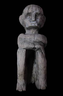
Sold2017Bulul, Rice god figureArtist unknown (Ifugao, 20th c.) Bulul. Tribal wood carving from the Ifagao people of Luzon, Philippine Islands depicting a rice god or guardian. Carved lightweight wood 20th century Measurements 24"See Sold Price
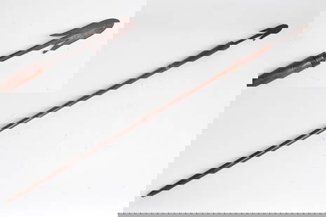
Sold2023Ifugao Falfeg 'Harpoon' SpearNorthern Philippine, Luzon Island falfeg spear of the Ifugao peoples with bulbus 'Harpoon' style tip and tapered wood shaft. 48 3/4" LSee Sold Price
Sold20237 Spanish-American War Prints and MapIncludes Benjamin Franklin Bridge etching, Map of Philippine Islands Manila Bay and Approaches, USS Olympia, and more. LR / MG IMPORTANT: Before bidding, please read the terms and conditions. When youSee Sold Price
Sold20211886 Map of the Philippine IslandsAuthor: Blackie Title: 1886 Map of the Philippine Islands Medium: Ink on Paper Dimensions: 10.5"X15" Map of the Philippine Islands dated 1886. Part of the Imperial Atlas of Modern Geography. This wasSee Sold Price
Sold20201898 Map of the Philippine IslandsAuthor: Cram Title: 1898 Map of the Philippine Islands Medium: Ink on PaperDimensions: 14.5"X22" Map of the Philippine Islands dated 1898. Engraved and published by George Cram in Chicago. Double foliSee Sold Price
Sold2017Weller: Antique Map of Borneo & Philippines, 1863Title/Content of Map: 'Borneo; The Philippine Islands' East Indies. Manila Zebu/Cebu. Date Printed: 1863 Image Size: Approx 32.0 x 43.5cm, 12.5 x 17.25 inches (Large) Type: Antique map with original oSee Sold Price
Sold2019BORNEO & THE PHILIPPINE ISLANDS. East Indies. ManilaTITLE/CONTENT OF MAP: 'Borneo; The Philippine Islands' DATE PRINTED: 1863 IMAGE SIZE: Approx 32.0 x 43.5cm, 12.5 x 17.25 inches (Large) TYPE: Antique map with original outline colour CONDITION: Good;See Sold Price
Sold20211938 R Taylor White Pictorial Map of the PhilippineTitle: 1938 R Taylor White Pictorial Map of the Philippine Islands -- Philippine Islands Cartographer: Ruth Taylor White Year / Place: 1938, Boston Map Dimension (in.): 11.6 x 8.5 in. This is Ruth TaySee Sold Price
Sold20181938 R Taylor White Pictorial Map of the PhilippineTitle/Content of Map: 1938 R Taylor White Pictorial Map of the Philippine Islands -- Philippine Islands Date Printed: 1938, Boston Cartographer: Ruth Taylor White Size: 11.6 x 8.5 in. This is Ruth TaySee Sold Price
Sold2024BORNEO & THE PHILIPPINE ISLANDS. East Indies. Manila Zebu/Cebu. WELLER 1863 mapTITLE/CONTENT OF MAP: 'Borneo; The Philippine Islands' DATE PRINTED: 1863 IMAGE SIZE: Approx 32.0 x 43.5cm, 12.5 x 17.25 inches (Large) TYPE: Antique map with original outline colour CONDITION: Good;See Sold Price
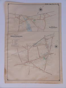
Sold2016Bridgehampton & Watermill, Long Island, 1902Original engraving published by E. Belcher Hyde from "Atlas of Suffolk County, Long Island, New York," Philadelphia, 1902. Map features family names, historic buildings and railroad routes. DimensionsSee Sold Price
Sold2016Map of Bermuda Islands, 1902Title: Map of Bermuda Islands Original engraving by George Cram Date: 1902 Dimensions: 11 x 14 inches No Reserve: This lot starts at $1 and has no reserve as a courtesy so that collectors can determinSee Sold Price
Sold20231902 Cram Map of Long Island -- Map of Long Island New YorkTitle: 1902 Cram Map of Long Island -- Map of Long Island New York Cartographer: G Cram Year/Place: 1902, Chicago Dimensions: 9.8 X 12.4 in. Description: This is an attractive map of Long island withSee Sold Price
Sold2017Map of Hawaii and the Philippines, 1898Map: 1898 Map of Hawaii and the Philippines -- The Philippine Islands and Hawaii Cartographer: Century Co. Year / Place: 1898, New York Map Dimensions: 10.4 x 14.7 in. An unsual, rare and interestingSee Sold Price
Sold20191905 Map of Hawaii and the Philippines -- TheTitle/Content of Map: 1905 Map of Hawaii and the Philippines -- The Philippine Islands and Hawaii Cartographer: Century Co. Size: 10.4 x 14.7 in. An unsual, rare and interesting combination of the PacSee Sold Price
Sold2018Rand-McNally Indexed Atlas. Philippine IslandsTitle/Content of Map: Rand-McNally Indexed Atlas. Philippine Islands Date: 1904 ca. Cartographer: RAND, MCNALLY & CO. Size: 26 X 19 Page xxii, xxiii from Rand, McNally & Co.'s Enlarged business atlasSee Sold Price
Sold2016Map of New Zealand, South Island, 1902Title: Map of New Zealand, South Island (Chatham & Tasmania) Original engraving by George Cram Date: 1902 Dimensions: 11 x 14 inches Description: Features insets of Chatham Islands & Tasmania on Van DSee Sold Price
Sold2016Map of New Zealand, North Island, 1902Title: Map of New Zealand, North Island Original engraving by George Cram Date: 1902 Dimensions: 11 x 14 inches No Reserve: This lot starts at $1 and has no reserve as a courtesy so that collectors caSee Sold Price
Sold2023Map of Spanish Empire in the Americas, the Pacific and Europe until 1898Map of Spanish Empire in the Americas (Cuba y Puerto Rico), the Pacific (the Philippine archipelago) and Europe (Canary Islands) until 1898. Size: 24x16. Condition: good.; Until 1898 Spain maintainedSee Sold Price
Sold2022Jose Formoso Reyes Nantucket Friendship Basket with Carved Nantucket Island on the LidJose Formoso Reyes (1902-1980) Nantucket Friendship Basket with Carved Nantucket Island on the Lid, signed upon the base "Made in Nantucket, Jose Formoso Reyes 1966" with outline map of Nantucket IslaSee Sold Price
Sold202119th C. Philippine Ifugao Wood Ceremonial Spoon (Pakko)**Originally Listed At $550** Southeast Asia, Philippines, Luzon Island, Ifugao, 19th century. A masterfully carved wooden ceremonial spoon (pakko) presenting a figural handle in the form of a seatedSee Sold Price
Sold202119th C. Philippine Ifugao Wood Spoon w/ Figural HandleSoutheast Asia, Philippines, Luzon island, Ifugao culture, ca. 19th to early 20th century CE. A hand-carved wooden spoon known as a pakko with a figural handle depicting a figure with either two headsSee Sold Price
Sold202319th C. Philippine Ifugao Wood Spoon Figural Handle**Originally Listed At $450** Southeast Asia, Philippines, Luzon Island, Ifugao culture, ca. 19th to early 20th century CE. A hand-carved wooden spoon known as a pakko with a figural handle depictingSee Sold Price
Swann Auction GalleriesDyer, Dr. Lora Genevieve (1880-1969) Very Large Archive including Journals, Letters, Photographs, an$2,600(1 bid)
17 hrs LeftAkiba Galleries(2 Pc) Allain Manesson Mallet Description De L'Univers 2 Vol. German Translation$200(1 bid)
465 Lots AwayActivity Auctions**Original 1950 Vintage MCM Airline Travel Poster** DOLE MAP OF HAWAIIAN ISLANDS**$450
1 day LeftJasper521894 Johnston Map of Oceania [verso] Island in the Indian Ocean and Near Africa -- Oceania [verso]$40
1 day LeftJasper521798 La Perouse Map of the Samoan Islands -- Chart of the Archipelago of Navigators…$110
4 days LeftAlbion AuctionsStieler, Adolf 1909 Antique Map. New Zealand - South Sea Islands, Pacific Australia Hawaii$5
2 days LeftJasper52MEDITERRANEAN.Corsica Sardinia;Balearics Baleares;Valletta,Malta SDUK 1844 map$100
2 days LeftJasper52MEDITERRANEAN.Corsica Sardinia;Balearics Baleares;Valletta,Malta.SDUK 1844 map$100


![Philippine Islands Map, George Cram, 1905: Philippine Islands. George Cram. 1899. 488, 489 Detailed national map with four insets: Caroline Islands, Manila [Bay], Mariana Is., and Lower part of Mindanao. U.S. city plans for Cleveland and Colum](https://p1.liveauctioneers.com/5584/102908/52607326_1_x.jpg?height=310&quality=70&version=1492721880)


![1894 Johnston Map of Oceania [verso] Island in the Indian Ocean and Near Africa -- Oceania [verso] (1 of 2)](https://p1.liveauctioneers.com/5584/328338/176911535_1_x.jpg?height=282&quality=70&version=1715113718)


