Sold2019Large map, New York City's UWS, 1879Large map, New York City's UWS, 1879, "West End Plateau of New York" by Herman K. Viele, City Surveyor, printed by Johnson & Pratt, New York, 1879, framed under acrylic, with 25-page booklet in pocketSee Sold Price
Sold2022Large Rollout Map of New York - Roughly 43" x 52"Large Rollout Map of New York - Roughly 43" x 52"See Sold Price
Sold2019LARGE WALL MAP ULSTER COUNTY NEW YORKLARGE WALL MAP ULSTER COUNTY NEW YORK-OLIVER TILLSON, C. 1853 44" X 54"See Sold Price
Sold2017Johnson: New York State Map, 1866Map: 1866 Johnson's New York State Map -- Johnson's New York Cartographer: A Johnson & Co. Year/Place: 1866 New York Dimensions: 17 x 24 in. This is a large double page map of New York state with muchSee Sold Price
Sold2022Large bound Insurance Maps of BROOKLYN, NEW YORK, Volume 10A, Sanborn Map Co. 1929. Was in basement,Large bound Insurance Maps of BROOKLYN, NEW YORK, Volume 10A, Sanborn Map Co. 1929. Was in basement, does have damp odor, intact, cover boards measure 27.5" x 21". From local estate.See Sold Price
Sold2021Antique 1858 Wall Map of Columbia County,NY New YorkLarge antique c.1858 map of Columbia county New York. This large map has lots of great details. It is perfect for anyone interested in local Hudson Valley history. The dimensions are 57in x 66in x 1.5See Sold Price
Sold2018Large lot early maps, New Orleans, Boston, New York,Large lot early maps, New Orleans, Boston, New York, Mamaroneck, also includes several atlas. All items sold as is as found, please refer to images for additional condition issues, all sales final.See Sold Price
Sold2022Large lot of 1960s Nautical Chart Maps New York Harbor, Harlem River, Hudson River, Raritan RiverLarge lot of 1960s Nautical Chart Maps New York Harbor, Harlem River, Hudson River, Raritan RiverSee Sold Price
Sold2022(NEW YORK.) John Homer French. The State of New York from New and Original Surveys.(NEW YORK.) John Homer French. The State of New York from New and Original Surveys. Large hand-colored engraved wall map of New York with many inset views and detail maps. 4 sheets joined, 68x73 incheSee Sold Price
Sold2021Antique 1858 Wall Map,Dutchess County,NY Rhinebeck,EtcAntique 1858 Wall Map,Dutchess County,NY Rhinebeck,Etc. This Large detailed antique map of Dutchess county New York is dated 1858. This large map has lots of great little details including drawings anSee Sold Price
Sold2021Large Antique Hanging Map of Columbia County NY 1858Large Antique Hanging Map of Columbia County New York from 1858. Shows details and insets of towns and villages in Columbia county. Has a top piece made to hang on the wall. Has a beautiful patina andSee Sold Price
Sold2018Large/scarce 1861 map of New York BayReserve Reduced! Large and scarce 1861 coastal map of New York City and its harbor. One of the earliest 19th century charts to depict New York City as we know it today. It shows Manhattan, Brooklyn anSee Sold Price
Sold2020Scarce 1864 and 1866 Dripps maps of NYCDetailed and scarce large format 1864 and 1866 maps of New York City and Vicinity by Matthew Dripps, both appearing in Valentine's Manual. The 1864 map covers the entire island of Manhattan as well asSee Sold Price
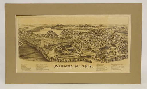
Sold2022Wappingers Falls New York Large ViewWappingers Falls, N.Y. Large Panorama Bird's-eye Map. L.R. Burleigh, Troy, New York, c. 1889. Antique print. 15" x 29".See Sold Price
Sold2018LARGE ANTIQUE HAND COLORED MAP JEFFERSON COUNTY NYLarge antique hand colored map of Jefferson County, New York. Circa 1855. Framed in large wooden frame and laid down to canvas backing. Condition: mounted/laid on canvas for preservation, some areas rSee Sold Price
Sold2022(CIVIL WAR.) Issue of the New York Herald announcing "The Surrender of Lee and His Whole Army."(CIVIL WAR.) Issue of the New York Herald announcing "The Surrender of Lee and His Whole Army." Large map on final page. 8 pages, 22¼ x 15½ inches, on 2 disbound folding sheets; minor wear aSee Sold Price
Sold2017Map of New York City[ANTIQUARIAN MAP; NEW YORK CITY] MAP OF NEW YORK CITY Showing Portions of Brooklyn, Jersey City, and Westchester Co., Rand-McNally & Co., 1899, original large map 27” high x 22” across including aSee Sold Price
Sold2018New York Central & Hudson River Railroad. 1903.Reserve Reduced! Item: New York Central & Hudson River Railroad. 1903. Date: 1903 Cartographer: MATTHEWS-NORTHRUP Publisher: NYC&HR R.R. Size (inches): 20.5X35.75 Large map with routes shown in colorsSee Sold Price
Sold2018Antique Wall Map NEW YORK POSTAL ROUTES 1898 MailDetails: This large hanging wall map of postal routes in the state of New York was created by topographer A. von Haake, and printed by "Julius Bien & Co., Photo. Lith." Dated March, 1, 1898, this mapSee Sold Price
Sold20211964 New York World's Fair Brochures and Maps - LargeLarge Group Lot of 1964 New York World's Fair Brochures and Maps. Over 40 Pieces. This sale will be broadcast live on sale day with an auctioneer and caller calling full descriptions of each lot beingSee Sold Price
Sold2021Large Lot of Vintage New York State Books & PamphletsLarge Lot of Vintage New York State Books & Pamphlets. Includes: 2 Rip Van Winkles Books, Washington Irving Maps New York Folklore Quarterly History of Erie Canal New York Historical Society JournSee Sold Price
Sold2022Colton & Johnson C1870 Pair of Large Maps of Turkey"Turkey in Europe" and "Austria, Turkey in Europe and Greece" Hand Colored Lithograph Maps Published C1856-70's, New York for "Colton's Atlas Of The World" by J. H. Colton and "Johnson's New IllustratSee Sold Price
Sold2022J.H. COLTON (1800-1893) A MAP, "New Map of the State ofJ.H. COLTON (1800-1893) A MAP, "New Map of the State of Texas," NEW YORK, CIRCA 1855, hand-colored lithograph on paper, "Compiled from J. de Cordova's large Map," and, "Published by J.H. Colton & Co.,See Sold Price
Sold2019[Map, Large] Lloyd's Map of the Southern States 1862"Lloyd's Map of the Southern States Showing all the Railroads, their Stations & Distances… 1862." New York: J. T. Lloyd, [1862.] Colored by state. Large map, measured from neatlines 51.25" x 37". CoSee Sold Price
2 days LeftPotter & Potter AuctionsBOURNE, Emma (1906 – 1986). America – A Nation of One Peopl...$125(1 bid)
Jun 12Dan Morphy AuctionsPHELPS’S TRAVELERS GUIDE THROUGH THE UNITED STATES; CONTAINING UPWARDS OF SEVEN HUNDRED$1,000
18 hrs LeftJasper521796 VOYAGES of CAPTAIN COOK 3 vols 1st US EDITION ILLUSTRATED antique ENGLISH$1,000
May 30NY Elizabeth FIRST US EDITION OF 1869 MALAY ARCHIPELAGO BY A.WALLACE, ANTIQUE ILLUSTRATED WITH MAPS$50(1 bid)
May 29Carlo Bonte AuctionsA large 'New York' circular vase by Longwy, limited edition, Ndeg 29/50, H 40 cm€600
2 days LeftPotter & Potter AuctionsBOLLMANN, Hermann (1911 – 1971). Map of New York City. 1962.$100
2 days LeftPotter & Potter Auctions[NEW YORK CITY – PICTORIAL MAPS]. Group of 3 pictorial maps...$200(1 bid)
May 22Thomaston Place Auction GalleriesCOLLECTION OF TRAVEL EPHEMERA, BROCHURES, BOOKLETS, MAPS 1900-1950$100
2 days LeftPotter & Potter AuctionsCrosby Service Pictorial Map of Manhattan (New York City). ...$250
3 days LeftSouth Beach Antiques LLCRoma New York “Sponge Black” Large 19” Inch Oval Serving Platter$25


![Map of New York City: [ANTIQUARIAN MAP; NEW YORK CITY] MAP OF NEW YORK CITY Showing Portions of Brooklyn, Jersey City, and Westchester Co., Rand-McNally & Co., 1899, original large map 27” high x 22” across including a](https://p1.liveauctioneers.com/1163/104811/53672586_1_x.jpg?height=310&quality=70&version=1496428876)


![[Map, Large] Lloyd's Map of the Southern States 1862: "Lloyd's Map of the Southern States Showing all the Railroads, their Stations & Distances… 1862." New York: J. T. Lloyd, [1862.] Colored by state. Large map, measured from neatlines 51.25" x 37". Co](https://p1.liveauctioneers.com/3532/154050/77745068_1_x.jpg?height=310&quality=70&version=1572759985)


![[NEW YORK CITY – PICTORIAL MAPS]. Group of 3 pictorial maps... (1 of 3)](https://p1.liveauctioneers.com/928/325952/175495562_1_x.jpg?height=282&quality=70&version=1712935174)


