Sold2022Large Framed 1846 Map of FloridaLarge Framed 1846 Map of Florida; a reprint of the original, matted, glazed, and mounted in a wood frame. This map shows the state when central Florida was one large county aptly named Mosquito. All aSee Sold Price
Sold2020Large Framed Map of London, 1861Depicts London from the South Side of the Thames, this was a fold-out supplement to the illustrated London News, February 9, 1861, Rob Loudon Sr. Folds, creases, water stains in areas. Overall size: 2See Sold Price
Sold2022Large Framed Map of the City of Worcesterhas some creasing but presents nicely in the frame - Frame 71" x 61" Please see photos and come to the 2 day preview for condition.See Sold Price
Sold2022LARGE FRAMED & GLAZED PRINT BY MILTON AVERY, 221/2" X 33 1/2" SIGHT, 31 1/2" X 41 1/2" OVERALLSee Sold Price
Sold2023ESTATE OF SEYMOUR STEIN: 3 LARGE FRAMED MAPS/PRINTS - NY, PEEKSILL, PHILADELPIA EXHIBITION, LARGESTESTATE OF SEYMOUR STEIN: 3 LARGE FRAMED MAPS/PRINTS - NY, PEEKSILL, PHILADELPIA EXHIBITION, LARGEST IS 40" X 41"See Sold Price
Sold2018Large Framed 1794 Map of America Laurie & Whittle1794, London New Map of America & The West India Islands. With detailed side maps of California, and Baffin & Hudson Bay. Published by Laurie and Whittle. Map measures approximately 43.5" L x 49.5" H,See Sold Price
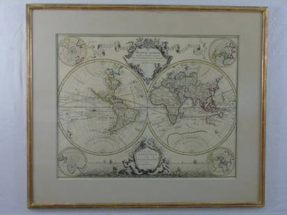
Sold2016Large Framed World Map w/ Latin InscriptionsLarge Framed World Map w/ Latin Inscriptions. Hand colored. Professionally framed and matted. Titled Mappe Monde. Measures 28 by 33 inches.See Sold Price
Sold2023James Cook Antiquated MapAntiquated framed and glazed map / 'agenera chart' depicting the voyages and discoveries of Captain James Cook height 28 in. x width 42 in. x depth 1.5 in. We happily provide seamless shippiSee Sold Price
Sold2023Delaware and Hudson RR Framed Bridge Line Route Map 1823-1973This large framed poster/map is from the Delaware and Hudson Railroad and shows their routes for both canal and railroad from 1823 to 1973, between New England and Canada. An excellent, full color pieSee Sold Price
Sold2021Large Matted and Framed Map of Norfolk Virginia:Large Matted and Framed Map of Norfolk Virginia: Stylized Blazon Coat of Arms of Howard Duke of Norfolk (Premier Duke of England) Motto is "Virtuecont Alone is Invincible". Labeled JH DINGEE, Banker,See Sold Price
Sold2018Large 19th C. Framed Map of FloridaLarge 19th C. Framed Map of Florida. Image size: 26.5 inches.See Sold Price
Sold2021Large Hand Colored Framed Map of Italy, StanfordsLarge Hand Colored Framed Map of Italy, Stanfords. Dated 1859. Sight size: 4'8"h x 47-1/2"w Overall: 5'4"h x 4'7"w. Item cannot be unframed as it consists of multiple hand colored maps completing theSee Sold Price
Sold2023Framed Map of Spanish & Mexican Land Grants for King RanchFramed and glazed colored map depicting the coastal area between the Rio Grande and The Nueces, showing early Spanish and Mexican land grants for King Ranch as of 1852 We happily provide seamless shiSee Sold Price
Sold2020SOUTHERN STATES TRADE ROUTE MAPLarge Framed Trade Route Map showing waterways and towns from the Mississippi River to Charles Town. Geographic Area Covered: Southern States, South Carolina,Santee River Valley, Savannah River ValleySee Sold Price
Sold20231899 State of New York Framed Railroad Map - Colton Ohman & Co. PrinterLarge framed 1899 railroad map of the state of New York. This map was created by James B. Lyon to accompany the seventeenth annual report of the Board of Commissioners of the State of New York. The maSee Sold Price
Sold2022Large Framed Johnson's Mercator's Projection Map of the World 40"x34" World MarketLarge Framed Johnson's Mercator's Projection Map of the World 40"x34" World MarketSee Sold Price
Sold2022Pan American Clipper Club World Pushpin MapLarge Framed Pan American World Map which reads “Be it witnessed and Known The Clipper travel on this map is that flown by Joel Bonsall distinguished member of the Pan Am Clipper Club” witSee Sold Price
Sold2019c1777 Map of the Gulf of Mexico by Thomas Kitchinc1777 Map of the Gulf of Mexico by Thomas Kitchin A very attractive hand coloured map of the Gulf of Mexico by Thomas Kitchin, which has been mounted, framed and glazed. The full title is ‘MAP OF THSee Sold Price
Sold2020Antique Framed Hand Colored Large Map of GrenadaAntique Professionally Framed French Hand Colored Large Map of Grenada. Entitled Carte de L'Isle, de la Grenade. Double matted. 43 inches x 30 inchesSee Sold Price
Sold2022Indo-Persian miniature painting. 18th century. Ink, colors and gilt on heavy paper. Scene of aIndo-Persian miniature painting. 18th century. Ink, colors and gilt on heavy paper. Scene of a nobleman holding a large diamond. 9.5 x 7in. Framed and glazed.See Sold Price
Sold2017The USA Map 1829, Engraving by W. Darton, London, UKThe United States of America, 1829 by W. Darton Junior, Holborn Hill. England. Hand colored engraved atlas map. Relief is shown pictorially. Map framed, matted and glazed. Publisher 1829, William DartSee Sold Price
Sold2020World MapPrinted Map Of The World. Glazed And framed. Measures 23 1/2 inches x 35 1/2 inches wide.See Sold Price
Sold2018LARGE PRESIDENTIAL CAMPAIGN BADGE, "WM MCKINLEY FORLARGE PRESIDENTIAL CAMPAIGN BADGE, "WM MCKINLEY FOR PRESIDENT-AN HONEST DOLLAR", 1896, MADE BY JAMES MERDOCK. OVERALL/HEIGHT 6 3/4"; DIAMETER 5"; FRAMED & GLAZED-12 X 40"See Sold Price
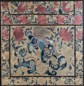
3 days LeftMa San AuctionA LARGE CHINESE FRAMED SILK EMBROIDERED PANEL, EARLY 20TH CENTURY. Featuring a central guardian lion£120(1 bid)
Jun 07Freeman's | Hindman[MAP]. ORTELIUS, Abraham. Americae Sive Novi Orbis, Nova Descriptio. 1573.$1,000(1 bid)
Jun 07Freeman's | Hindman[MAP]. ORTELIUS, Abraham. Peregrinationis Divi Pauli Typus Corographicus. 1592.$150
Jun 07Freeman's | Hindman[MAP]. ORTELIUS, Abraham. Presbiteri Iohannis, sive, Abissinorum Imperii Descriptio. 1592.$200
May 22Thomaston Place Auction GalleriesHAND COLORED MAP OF PERU & COUNTRY OF THE AMAZONS, 1747, BY EMANUEL BOWEN, FRAMED$250


![[MAP]. ORTELIUS, Abraham. Aevi Veteris, Typus Geographicus. 1601. (1 of 3)](https://p1.liveauctioneers.com/197/329395/177650532_1_x.jpg?height=282&quality=70&version=1715364962)


![[MAP]. ORTELIUS, Abraham. Americae Sive Novi Orbis, Nova Descriptio. 1573. (1 of 2)](https://p1.liveauctioneers.com/197/329395/177650534_1_x.jpg?height=282&quality=70&version=1715364962)
![[MAP]. SPEED, John. A New Mappe of the Romane Empire. 1676. (1 of 2)](https://p1.liveauctioneers.com/197/329395/177650541_1_x.jpg?height=282&quality=70&version=1715364962)
![[MAP]. ORTELIUS, Abraham. Turcici Imperii Descriptio.1592. (1 of 2)](https://p1.liveauctioneers.com/197/329395/177650538_1_x.jpg?height=282&quality=70&version=1715364962)
![[MAP]. ORTELIUS, Abraham. Romani Imperii Imago. 1592. (1 of 2)](https://p1.liveauctioneers.com/197/329395/177650537_1_x.jpg?height=282&quality=70&version=1715364962)
![[MAP]. ORTELIUS, Abraham. Peregrinationis Divi Pauli Typus Corographicus. 1592. (1 of 2)](https://p1.liveauctioneers.com/197/329395/177650535_1_x.jpg?height=282&quality=70&version=1715364962)
![[MAP]. ORTELIUS, Abraham. Africae Tabula Nova. 1592. (1 of 2)](https://p1.liveauctioneers.com/197/329395/177650533_1_x.jpg?height=282&quality=70&version=1715364962)
![[MAP]. ORTELIUS, Abraham. Presbiteri Iohannis, sive, Abissinorum Imperii Descriptio. 1592. (1 of 2)](https://p1.liveauctioneers.com/197/329395/177650536_1_x.jpg?height=282&quality=70&version=1715364962)


