Sold2021Floating Pink Spinel Ring with DiamondsUnique floating vibrant 5 carat pink spinel with 1.80 carats of diamonds underneath F-SASee Sold Price
Sold2020G. Braun & F. Hogenberg: MAP OF PARIS, 1575Bird’s-eye view of the city of Paris and surrounding countryside; Title in cartouche: "LUTETIA vulgari nomine Paris, urbs Galliae maxima" From Braun and Hogenberg’s atlas “Civitates Orbis TerrarSee Sold Price
Sold2022San Francisco Tide Lands for sale at auctionHeading: -1871 Author: Allardt, Geo. F., Surveyor Title: Map No. 6 of Salt Marsh and Tide Lands situated in the City and County of San Francisco, to be sold at public auction by order of the Board ofSee Sold Price
Sold2021FRANCO ALBINIFRANCO ALBINIMobile mod, MB15Mobile contenitore in legno.Prod. Poggi anni '60cm 74x240x47Bibl.: R. Dulio, F. Marino, S.A. Poli, Il Mondo di Poggi, l'officina del design e delle arti, Electa 2019, pag.See Sold Price
Sold2022Map of San Francisco Tidelands for sale, 1869Heading: -1869 Author: Allardt, Geo. F., Surveyor Title: Map No. 3 of Salt Marsh and Tide Lands Situate in the City & County of San Francisco. To be sold at Public Auction, by order of the Boards of TSee Sold Price
Sold2024FRANCO ALBINIFRANCO ALBINICarrello mod. CR20Legno.Prod. Poggi 1958cm 69x68x45Bibl.: Giuliana Gramigna, Repertorio 1950-1980, Mondadori, Milano, 1985, pag. 126Bibl.: R. Dulio, F. Marino, S.A. Poli, Il Mondo di PoggSee Sold Price
Sold2024FRANCO ALBINI (1905-1977) & FRANCA HELG (1920-1989) Pair of single LT28 beds for Poggi, Pavia.FRANCO ALBINI (1905-1977) & FRANCA HELG (1920-1989) Pair of single LT28 beds for Poggi, Pavia. 1961. Walnut.. Cm 205,50 x 98,00 x 101,00. Literature: R. Dulio, F. Marino, S.A. Poli, Il mondo di Poggi.See Sold Price
Sold2018Map of Texas Oil Drilling Sites"Gallup's Map of Texas, Published by F.E. Gallup Map Co." Sight size: 20-1/2"h x 29"w Provenance: Bought from rare book sealer in Santa Fe, New Mexico.See Sold Price
Sold2018A saddle by F. G. Schmidtdating: 20th Century provenance: Brazil, Wooden structure, completely covered with leather, with rich floral and geometrical imprints, manufacturer's stamp 'F.G. SCHMIDT S.A.' with address in Brazil.See Sold Price
Sold2022San Mateo Co., Cal., Tide Lands at auction 1871Heading: (California - San Mateo County) Author: Allardt, Geo. F., Surveyor Title: Sale Map No. 9. Salt Marsh and Tide Lands situate in the County of San Mateo, State of California. To be sold at publSee Sold Price
Sold2022England.- Izacke (Richard) Remarkable antiquities of the city of Exeter, Printed for RowlandEngland.- Izacke (Richard) Remarkable antiquities of the city of Exeter, engraved armorial frontispiece and folding map, final f. blank, burnhole to frontispiece, map with repaired split at a fold, soSee Sold Price
Sold2017FW Falls Long Island NY Yard Long ChromolithographUNITED STATES, EARLY 20TH CENTURY A yard long chromolithograph of Long Island, New York after F.W Falls. The map illustrates the topography of Long Island, Manhattan, and Montauk giving a representatiSee Sold Price
Sold2022(NEBRASKA.) F. Hirschfield, Civil Engineer. Map of Nebraska Published by the State Journal Co.,(NEBRASKA.) F. Hirschfield, Civil Engineer. Map of Nebraska Published by the State Journal Co., Lincoln, Neb. Large color-printed lithographed pocket map of the state of Nebraska. 23x40 inches overallSee Sold Price
Sold2023[MAP] DE WIT, F. NOVA ORBIS TABULA IN LUCEM EDITAde Wit, Frederik. NOVA ORBIS TABULA, IN LUCEM EDITA. (Amsterdam: circa 1670s.) Beautiful map in exquisite full handcolouring, with elaborate corner scenes illustrating the four seasons and the Zodiac,See Sold Price
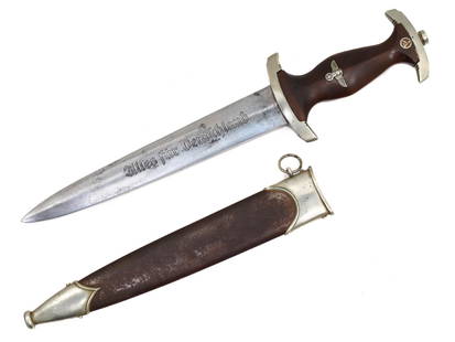
Sold2021A GERMAN GROUND ROHM SA DAGGER BY F. HERDER A.S.SA dagger by F. Herder A.S. A typical for the maker dark grip with silvered SA-style German national eagle and enameled SA insignia, the reverse of the crossguard bears "Wf" stamp, blade with maker'sSee Sold Price
Sold2022LONDON UNDERGROUND tube map diagram plan. First STINGEMORE edition 1925TITLE/CONTENT OF MAP: Underground Railways of London [694 11.5.25] This is the first edition of an Underground geographic map designed by F H Stingemore. It is one of the first designs not to show anySee Sold Price
Sold2023"Atlas Of The Hudson River Valley From New York City To Troy", by F.W. Beers, hand colored maps in"Atlas Of The Hudson River Valley From New York City To Troy", by F.W. Beers, hand colored maps in large folio, published by Watson & Co. New York 1891. Each map page with canvas backing so most map pSee Sold Price
Sold2020F. B. Werner, "Roma" hand-colored map, 1730F. B. Werner, "Roma" hand-colored map, 1730, Panoramic view of Rome, hand-colored engraving on laid paper, no watermark observed, two sheets joined at center, marked "F. B. Werner delin Ao 1730" and "See Sold Price
Sold20231788 VOYAGE TO AMERICA by F. CHASTELLUX antique ILLUSTRATED w / MAPS 2 VOLUMESVOYAGES DANS L'AMÉRIQUE SEPTENTRIONALE, DANS LES ANNÉES 1780, 1781 & 1782 2 volumes by CHASTELLUX, François-Jean de Paris; 1788-1791 8vo: 5 1/4 by 8 1/4" [8]-408, [4]-251 pp. Second autSee Sold Price
Sold2016Cram's Lithographed Map of Oregon, 1881Cram's Railroad and Township Map of Oregon. George F. Cram. Hand-colored Lithographed Map. Chicago: Cram, 1881. from 'The Standard American Railroad Atlas'. 16 1/2 x 20 1/2 inches visible, 25 1/4 x 29See Sold Price
Sold2023Pictorial map of Washington StateHeading: (Washington) Author: Herman, John F. & Chark Teegarden Title: A Pictorial Map of Washington: The Evergreen State"" Place Published: Seattle, WA Publisher:Ridgway Litho. Co. Date PublisheSee Sold Price
Sold2023GEORGE CRAM'S AMERICAN ATLAS OF THE UNITED STATESGEORGE CRAM'S AMERICAN ATLAS OF THE UNITED STATESGeorge F. Cram, proprietor of the Western Map Depot, Chicago, IL, 1878. Color maps within.22.1 x 17.6 in. (56.1 x 44.7 cm.)See Sold Price
Sold2022OVAL NANTUCKET FRIENDSHIP BASKET BY JOSE F. REYESVintage Lightship Basket "Friendship" Pocketbook by Jose Formoso Reyes, with an ebony lid plaque, swing handle, latch pin and handle pegs, marked on base with map of Nantucket and 'Jose F. Reyes', 6 1See Sold Price
Sold2018Cram Map of TexasCRAM, George F (1842-1928). Railroad and county map of Texas. Lithograph with handcolor, with original black slipcase on the verso. Chicago, 1876. 17 3/4 x 24 inches sheet, 28 x 33 inches framedSee Sold Price
Jun 13Swann Auction Galleries(RHODE ISLAND.) Henry F. Walling. Map of the State of Rhode Island and Providence Plantations.$500
Jun 12Dan Morphy AuctionsPLATE CXIII. MAP OF INDIAN TERRITORY SHOWING DISTRIBUTION OF WOODLAND” FROM THE TWENTY-FIRST$100
7 days LeftJasper521680 de Vit Map of Northwest Germany and Netherlands -- Nova Totius Westphaliae Descriptio$120
2 days LeftFreeman's | HindmanWOOLWARD, Florence. The Genus Masdevallia... 1890-1896. FIRST EDITION.$1,200
1 day LeftHolabird Western Americana CollectionsWyoming History (3) 1899 & 1955 Reprints [182275]$200
BonhamsCHESTERFIELD (PHILIP DORMER STANHOPE, 4th Earl) Letters... to His Son Philip Stanhope, 2 vol., F...£400
Jun 13Swann Auction Galleries(CAPE COD.) Albert F. Poole. Bird's Eye View of the Village of Hyannis, Barnstable County, Mass.$1,100
BonhamsFIELDING (THEODORE HENRY) Cumberland, Westmoreland, and Lancashire Illustrated, in a Series of F...£600
BonhamsBASKERVILLE PRESS ADDISON (JOSEPH) The Works, 4 vol., Birmingham, Printed by John Baskerville, f...£500
BonhamsDICKENS (CHARLES) Autograph letter signed ('Charles Dickens'), to C.F. Smith ('Dear Sir'), Tavis...£750
BonhamsIRELAND - ULSTER COVENANT, U.V.F., CARSON AND CRAIG Album relating to the Ulster Covenant, James...£10


![[MAP] DE WIT, F. NOVA ORBIS TABULA IN LUCEM EDITA: de Wit, Frederik. NOVA ORBIS TABULA, IN LUCEM EDITA. (Amsterdam: circa 1670s.) Beautiful map in exquisite full handcolouring, with elaborate corner scenes illustrating the four seasons and the Zodiac,](https://p1.liveauctioneers.com/8124/310027/165853624_1_x.jpg?height=310&quality=70&version=1700184289)
![LONDON UNDERGROUND tube map diagram plan. First STINGEMORE edition 1925: TITLE/CONTENT OF MAP: Underground Railways of London [694 11.5.25] This is the first edition of an Underground geographic map designed by F H Stingemore. It is one of the first designs not to show any](https://p1.liveauctioneers.com/5584/263211/137236971_1_x.jpg?height=310&quality=70&version=1664917902)


![1788 VOYAGE TO AMERICA by F. CHASTELLUX antique ILLUSTRATED w / MAPS 2 VOLUMES: VOYAGES DANS L'AMÉRIQUE SEPTENTRIONALE, DANS LES ANNÉES 1780, 1781 & 1782 2 volumes by CHASTELLUX, François-Jean de Paris; 1788-1791 8vo: 5 1/4 by 8 1/4" [8]-408, [4]-251 pp. Second aut](https://p1.liveauctioneers.com/5584/304737/162633733_1_x.jpg?height=310&quality=70&version=1696971416)


![Wyoming History (3) 1899 & 1955 Reprints [182275] (1 of 3)](https://p1.liveauctioneers.com/2699/331494/178785555_1_x.jpg?height=282&quality=70&version=1717094654)
![Across America, Rusling, 1875 [181941] (1 of 9)](https://p1.liveauctioneers.com/2699/331494/178785461_1_x.jpg?height=282&quality=70&version=1717189774)

![History of Utah, Bancroft, 1890 [182273] (1 of 3)](https://p1.liveauctioneers.com/2699/331494/178785554_1_x.jpg?height=282&quality=70&version=1717094654)


