Sold2022MAP OF BRITISH & FRENCH SETTLEMENTS IN N. AMERICAby John Hinton London, University Magazine. 1755. 13 x 15 inches Together with a fragment of a second map of North America by J. Hinton. each printed on laid paper and hand colored Condition: Tear toSee Sold Price
Sold20211734 Weigel Map of French and British Pocessions inTitle: 1734 Weigel Map of French and British Pocessions in America -- Novissima Tabula Regionis Ludovicianae Gallice dicta la Louisiane… Cartographer: C Weigel Year / Place: 1734, Nurnberg Map DimenSee Sold Price
Sold20241755 French & Indian War Period, Map of the NORTH AMERICAN BRITISH + FRENCH SETTLEMENTSHistoric Maps 1755 French & Indian War "A Map of the BRITISH and FRENCH SETTLEMENTS in NORTH AMERICA" 1755 French and Indian War Period, Map of North America titled, "A Map of the British and French SSee Sold Price
Sold2024A Map of the British and French Settlements in North America (London, 1755)A Map of the British and French Settlements in North America (London, 1755) "A map of the British and French Settlements in North America" by Thomas Bowen, engraved two-part folding map with hand coloSee Sold Price
Sold2021A GEORGE II FRENCH AND INDIAN WAR PERIOD MAP, "A Map ofA GEORGE II FRENCH AND INDIAN WAR PERIOD MAP, "A Map of the British and French Settlements in North America," LONDON, CIRCA 1755, hand-colored engraving on paper, by John Lodge Cowley (1719-1797), carSee Sold Price
Sold2018Amérique Septentrionale. British French Spanish NorthThis fabulous map shows North America divided between British (red), French (Green) and Spanish (Yellow) possessions. At this time the British colonies of New England, New York, New Jersey, PennsylvanSee Sold Price
Sold2021Early English map of U.S. 1783Heading: Author: Kitchin, Thomas Title: Map of the United States in North America: with the British, French and Spanish Dominions adjoining, according to the Treaty of 1783. Place Published: London PSee Sold Price
Sold2022Popple, Henry,(Britain, 16?? - 1743) A Map of The British Empire in America with French, Spanish and(d. 1743) Printed In Amsterdam For L Covens And C. Mortier c.1755, Sight View 19" x 18-1/2", Overall 21" x 26" "Carte Particuliere de l'Amerique Septentrionale."See Sold Price
Sold2018Key map of Popple's British North AmericaHeading: Author: Popple, Henry Title: A Map of the British Empire In America with the French, Spanish and the Dutch Settlements adjacent thereto by Henry Popple Place Published: Amsterdam Publisher:ISee Sold Price
Sold2024Jacques Nicolas Bellin Map Of Western Part Of New France Or CanadaPartie Occidentale de la Nouvelle France, by Mr. Jacques Nicolas Bellin, Marine Engineer, summarizes the knowledge of the region as the French knew it prior to the British invasionSee Sold Price
Sold2023Map of the British Empire in AmericaPublication Date: 1733 Title: Map of the British Empire in America Cartographer: Henry Popple Publisher: Covens & Mortier Height: 23 Width: 20.5 with the French, Spanish and the Dutch Settlements adjaSee Sold Price
Sold20241794 Laurie & Whittle after Thomas Jefferys Map Of The United States Of AmericaWITH THE BRITISH POSSESSIONS OF CANADA, NOVA SCOTIA, NEW BRUNSWICK, AND NEWFOUNDLAND divided with the French, also The Spanish Territories Of Louisiana and Florida according to the Premliminary ArticlSee Sold Price
Sold2023FRENCH ART DECO BRONZE SCULPTURE BY EMILE A LEROYEmile Andre Leroy, French, 1899 to 1953, patinated bronze sculpture depicting a Female Dancer. Mounted on a sphere shaped base. Inscribed, E. A. Leroy, on the backside of the base. Mounted on a marbleSee Sold Price
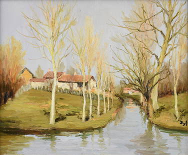
Sold2017Marcel Dyf (French 1899 - 1985) Bretagne LandscapeMarcel Dyf (French 1899 - 1985) Bretagne Landscape, ca. 1950 Oil on canvas Signed lower left 21 in. h. x 26 in. w., canvas 29.25 in. h. x 33 in. w., as framedSee Sold Price
Sold201718th C. French Map w/ Oiled Paper, ex-Sotheby'sEurope, France, map from 1709 CE, oiled paper overlays from 1756 to 1763 CE, owned by Louis-Alexandre Berthier (1753 to 1815 CE), Marshal, Vice-Constable of France, and Chief of Staff (Major general)See Sold Price
Sold2024EUROPE POLITICAL. Austria-Hungary. United Sweden & Norway. JOHNSTON 1899 mapTITLE/CONTENT OF MAP: 'Europe, political' DATE PRINTED: 1899 IMAGE SIZE: Approx 27.0 x 21.0cm, 10.5 x 8.25 inches (Medium) TYPE: Colour antique map CONDITION: Good; suitable for framing. The image shoSee Sold Price
Sold2019Marcel Dyf, Seaside Landscape with Gardener - 1978Marcel Dyf (French, 1899-1985). Landscape depicting a view on an ocean shoreline with woman gardening on the bank - 1978, oil on canvas, signed lower right, inscribed to verso with date and signature.See Sold Price
Sold2023MARCEL DYF (French 1899-1985) A PAINTING, "La Mauldre," 1973,MARCEL DYF (French 1899-1985) A PAINTING, "La Mauldre," 1973, oil on canvas, signed L/R, "Dyf," a Frost & Reed gallery stamp on the stretcher on verso reads "© Marcel Dyf / F+R 1973," also "884" inSee Sold Price
Sold2022Marcel Dyf (French, 1899-1985) Blés à ArzonMarcel Dyf (French, 1899-1985) Blés à Arzon signed 'Dyf' (lower right) oil on canvas 61 x 73.3cm (24 x 28 7/8in). Footnotes: Provenance With Frost & Reed, no. 435See Sold Price
Sold2022Marcel Dyf (French, 1899-1985) L'étang imaginaire (Painted in 1979.)Marcel Dyf (French, 1899-1985) L'étang imaginaire signed 'Dyf' (lower right) oil on canvas 38.1 x 46.1cm (15 x 18 1/8in). Painted in 1979. Footnotes: ProvenanceSee Sold Price
Sold2019Marcel Dyf, Still Life of Flowers, SignedMarcel Dyf (French, 1899-1985). Still life with pink, purple, and white flowers in a floral decorated vase, oil on canvas, signed lower right. Approx. 20.25" x 17.25" (frame), 13.75" x 10.75" (canvas)See Sold Price
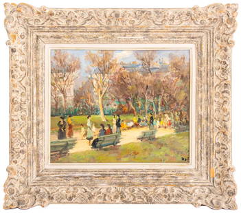
Sold2022Marcel Dyf "Jardin des Champs Elysees" OilMarcel Dyf (French, 1899-1985) "Jardin des Champs Elysees" oil on canvas, depicting a Parisian park scene, signed to lower right, "William Doyle Galleries" label to verso, housed in a carved wood framSee Sold Price
2024Marcel Dyf (1899-1985): Brittany AfternoonMarcel Dyf French 1899-1985 Brittany Afternoon oil on canvas c. 1970; signed lower right, titled to plaque Sight: 17 1/2 x 21 in. (44.5 x 53.3 cm.), Frame: 27 1/2 x 31 in. (69.9 x 78.7 cm.)See Sold Price
Sold2015Marcel Dyf. Still Life on Balcony, oil on canvas(French, 1899-1985). Signed "Dyf" lr, 21 3/4 x 18 1/4 in., framedSee Sold Price
7 days LeftJasper52INDOCHINA. Siam Burma Annam Cambodia Tong King Southern China. JOHNSTON 1913 map$45
Jun 07Freeman's | Hindman[MAP]. SARTINE, Antoine Plan de la Barre et du Havre de Charles-Town...1778. RARE REVOLUTIONARY WAR$1,000(1 bid)
BonhamsMARCEL DYF (French, 1899-1985) Jacqueline à la rose, 1960 (framed 95.0 x 82.0 x 7.0 cm (37 ...$600(2 bids)
13 hrs LeftZikorn Arts & History ObjectsWest Indies, Providence, Windward, Cuba 1834 British Admiralty Map$100(1 bid)


![[MAP]. SARTINE, Antoine Plan de la Barre et du Havre de Charles-Town...1778. RARE REVOLUTIONARY WAR (1 of 1)](https://p1.liveauctioneers.com/197/329395/177650540_1_x.jpg?height=282&quality=70&version=1715364962)


