Sold2019Three Maps by the Hydrographic Office U. S. Navy,Three Maps by the Hydrographic Office U. S. Navy, consisting of "Central American, West Coast of Nicaragua, Corinto Harbor and Approaches," 1929, H. - 30 in., W. - 42 in.; with "South Africa, BritishSee Sold Price
Sold20221888 Pilot Chart of the North Atlantic OceanPilot Chart of the North Atlantic Ocean, March 1888, by the Hydrographic Office U.S. Navy. Printed in grey, black, blue, and red inks. Good condition; some age toning, small separations at some fold cSee Sold Price
Sold2017Travel - Captain Silvers Sea Chart - North, Central &Captain Silvers Sea Chart - North, Central & South American Map - From Captain Silver onboard the Sea Hound. 19.75" x 26.75".See Sold Price
Sold2023Venezuela coast. Aruba Bonaire Curacao. ADMIRALTY sea chart 1894 (1955) mapSouth America - North Coast - Tortuga to Cabo la Vela // Catia de la Mar' by From the latest Documents in the Hydrographic Office with additions and corrections from United States and Netherlands GovtSee Sold Price
Sold2017Dépôt de la Marine: Chart of Martinique Harbors, 1828Map: Plan des Havres du Robert et du Francois (Ile de la Martinique) Cartographer: Depot-General de la Marine Place & Date: Paris / 1828 Size: 35 1/2" x 24 1/2" A large-scale French Hydrographic OfficSee Sold Price
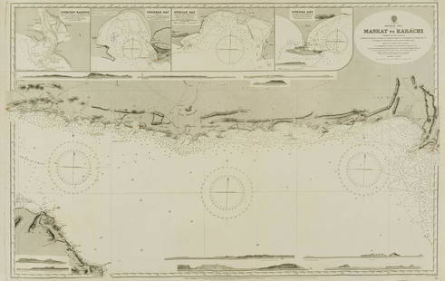
Sold2022Middle East.- Oman.- Admirality Hydrographic Office (The) Maskat to Karachi, engraved chart, 1916.Middle East.- Oman.- Admirality Hydrographic Office (The) Maskat to Karachi, showing the coast from Maskat to Karachi, the Gulf of Oman, with inset maps of Sonmoyani Harbour, Chahbar Bay, Gwatar Bay aSee Sold Price
Sold2020Central America Caribbean Gulf of Mexico chart PortsTITLE/CONTENT OF MAP: 'Central American and West Indian Ports; Inset The Pacific Coast from San Diego to Vancouver; San Francisco; Aleutian; The Pacific Coast from Seattle to Dutch Harbor; Bermudas; KSee Sold Price
Sold2024Central America Caribbean Gulf of Mexico chart Ports lighthouses LARGE 1952 mapTITLE/CONTENT OF MAP: 'Central American and West Indian Ports inset The Lesser Antilles; The Windward Passage; Bermudas; Kingston; Havana; Salina Cruz; Coatzacoalcos; Willemstad, Curacao' DATE PRINTEDSee Sold Price
Sold2024Central America Caribbean Gulf of Mexico chart Ports lighthouses LARGE 1927 mapTITLE/CONTENT OF MAP: Central American and West Indian Ports [inset The Lesser Antilles; The Windward Passage; Bermudas; Kingston; Havana; Salina Cruz; Puerto Mexico; Mouths of the Mississippi] DATE PSee Sold Price
Sold2018West Indies the Bahama Islands Exuma to New ProvidenceTitle/Content of Map: West Indies the Bahama Islands Exuma to New Providence Date Printed: 01/07/1975 Cartographer: HYDROGRAPHIC OFFICE. ROYAL NAVY Size (inches): 38X25 Detailed nautical chart. CopiouSee Sold Price
Sold2023AMERICAN MAYLINE MAP CASE.Second half 20th century, oak. In four sections with fire drawers per. Some water staining and no cap or base. Each section. 14"h. 41"w. 27.5"d.See Sold Price
Sold2022Jacob Monk Wall Map of North America 1860Monk's Standard American Map exhibiting the larger portion of North America Embracing The United States and Territories, Mexico, Central America, including the West India Islands, Canada, New BrunswicSee Sold Price
Sold2020Roy McLendon (b.1932) Florida Highwaymen PaintingRoy McLendon (American; Florida, born 1932). Original oil painting on canvas. Florida wetlands landscape, a central lake with water birds surrounded by cypress trees and other flora, fallen trees to tSee Sold Price
Sold2020Carnell Smith (1950-2015) Florida Highwaymen PaintingCarnell (Pete) Smith (American; Florida, 1950-2015). Original oil painting on canvas. Florida wetland landscape with wild water birds in flight over a central inlet with cypress and palm trees, mangroSee Sold Price
Sold2020Al Blood Black (b1947) Florida Highwaymen PaintingAl (Blood) Black (American; Florida, born 1947). Original oil painting on canvas panel. Florida wetlands landscape with water birds in flight, and a large central lake with cypress and palm trees, manSee Sold Price
Sold2022LARGE ARCHITECTS PRINT / MAP / CHART CABINETFantastic very large Architectural draftsman/chart/map/print flat file - George III-Style mahogany with satinwood inlay, inset tooled leather top. 8 Drawer over 4 drawer. from the Audubon Gallery, KinSee Sold Price
Sold2024Antique American Water Mill Stream Landscape Oil on Canvas Framed PaintingAntique American Water Mill Stream Landscape Oil on Canvas Framed Painting. Apparently unsigned. Fine sight condition as shown, please enlarge photos. Approx. canvas size 18" x 14". We Do Not ProvideSee Sold Price
Sold2015GROUP OF THREE STONE HEADSComprising: sandstone head on a wood plinth, height 9 1/2"; earthenware head of a Central American Native; and a pottery head of a Grecian, height 10 1/2". (150/200)See Sold Price
Sold2023Thirty Five Silver Cobbs and Caribbean Coins/CobbsThirty five silver cobbs, Caribbean, Spain Central American mix. Total weight: 10.50 ozt. Descriptions, weights, sizes and conditions are our best judgement and do not represent a guarantee. All jewelSee Sold Price
Sold2024American National Water Tower Fire Truck Pedal CarRestored American National water tower fire truck pedal car. The car was professionally restored with some re-manufactured parts. This was the largest fire pedal car produced. The ladders come off toSee Sold Price
Sold2020Jane Peterson (American, 1876–1965), , Water LiliesJane Peterson (American, 1876–1965) Water Lilies Signed 'JANE PETERSON' verso, oil on board 14 x 17 in. (35.6 x 43.2cm) PROVENANCE: Private Collection, Pennsylvania.See Sold Price
Sold2023Mary Ann Carroll Florida Highwaymen African American Moonlit Water Palm FL Oil PaintingTitle: Mary Ann Carroll Florida Highwaymen African American Moonlit Water Palm FL Oil Painting Description:Mary Ann Carroll Florida Highwaymen African American Moonlit Water Palm FL Oil Painting. On USee Sold Price
Sold2021AMERICAN NAT'L WATER TOWER PEDAL CAR396. AMERICAN NAT'L WATER TOWER PEDAL CAR | 87" l. | Contemporary Example. | $1,200 - $2,500See Sold Price
Sold2020Late 19th C. Southern Plains Hide Shield w/ FigureNative American, Central/Southern Plains, probably Cheyenne, Black Hawk, or Crow, ca. late 19th to early 20th century CE. An incredibly lightweight shield meant to be wielded while riding on horsebackSee Sold Price
2 days LeftZikorn Arts & History ObjectsEntrance to Baltic Great & Little Belt 1852 British Admiralty Map$100
2 days LeftZikorn Arts & History ObjectsWest Indies Pt. Manzanilla to San Juan 1844 British Admiralty Map$100
2 days LeftZikorn Arts & History ObjectsWest Indies, Cape Gracias to Belize 1843 British Admiralty Map$100
2 days LeftZikorn Arts & History ObjectsCentral America West Coast 1855 British Admiralty Nautical Chart$100(1 bid)
2 days LeftZikorn Arts & History ObjectsBosporus & Constantinople 1839 British Admiralty Nautical Chart$100(1 bid)
2 days LeftZikorn Arts & History ObjectsWest Indies, Providence, Windward, Cuba 1834 British Admiralty Map$100(1 bid)
May 25RbfineartsHistorical Map of the State of Kentucky by Karl Smith 1933 Daniel Boone & Companions View$20(1 bid)
17 hrs LeftJasper521647 Jansson Map Central Netherlands -- Ducatus Gelriae pars quarta quae est Arnhemiensis siue$95


![Central America Caribbean Gulf of Mexico chart Ports lighthouses LARGE 1927 map: TITLE/CONTENT OF MAP: Central American and West Indian Ports [inset The Lesser Antilles; The Windward Passage; Bermudas; Kingston; Havana; Salina Cruz; Puerto Mexico; Mouths of the Mississippi] DATE P](https://p1.liveauctioneers.com/5584/316569/169897699_1_x.jpg?height=310&quality=70&version=1706046386)


![[CIVIL WAR] Mississippi River Sketch (1 of 2)](https://p1.liveauctioneers.com/7226/325455/175168988_1_x.jpg?height=282&quality=70&version=1712370394)
