Sold2018Bridges: Antique Plan for New York City, 1870Title/Content of Map: 1870 Bridges Plan for New York City -- A Plan of New York City with Recent and Intended Improvements Date Printed: 1870 New York City Cartographer: J Hardy Size: 12.8 x 12.2 in.See Sold Price
Sold2022Public Health.- Houses of Parliament. First [-Third] Report of the Commissioners...into...PreventingPublic Health.- Houses of Parliament. First Report of the Commissioners...into...the Best Means of Preventing the Pollution of Rivers (River Thames), 2 vol., 12 maps & plans, most folding including laSee Sold Price
2019James Abbott McNeill Whistler "Old Hungerford Bridge"Artist: James Abbott McNeill Whistler Title: Old Hungerford Bridge Year: 1922 Portfolio: The Thames Set Medium: Etching from original etching Edition: From the rare limited edition of 200 SignatSee Sold Price
Sold2021Whistler "Old Hungerford Bridge" Etching on PaperJames Abbott McNeill Whistler (American, 1834-1903), etching and drypoint, circa 1871, "Old Hungerford Bridge" (Kennedy 76), the sixth of sixteen etchings from the "Thames Set," signed in plate lowerSee Sold Price
Sold2022Nineteenth Century Map of New YorkFramed map titled "Plan of the City of New York Engraved from the original map by G. Hayward from D.T. Valentines Manual for 1855". Map printed on blue paper measures 18.5" x 14" and exhibits folds, aSee Sold Price
Sold20221720 Strype Map of London Ward by Southwark Bridge on Thames -- Queen Hith Ward and VintryTitle: 1720 Strype Map of London Ward by Southwark Bridge on Thames -- Queen Hith Ward and Vintry Ward… Cartographer: J Strype Year / Place: 1720, London Map Dimension (in.): 11.9 X 6.9 in. ThisSee Sold Price
Sold20211855 Plan of Santiago Chile and AnotherLithograph plan of the city of Santiaho in Chile, printed at Washington DC, 1855 based on an expedition by Lieut. J.M. Gilliss. This accompanied by a Map of the province from the same report. Both FinSee Sold Price
Sold2022FINE REPRODUCTION MAP OF ANTEBELLUM BOSTONGeorge C. Smith's 1855 "Plan of Boston Comprising a Part of Charlestown and Cambridge", from the Collection of Norman B. Leventhal, Presented to Members of the MIT Class of 1938, on the Occasion of thSee Sold Price
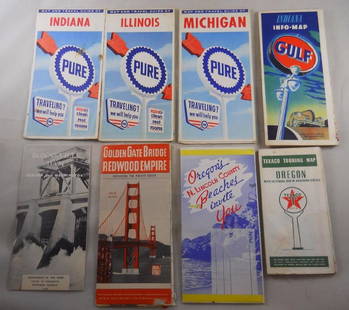
Sold2018Grouping of vintage gas station road maps and travelPure, Gulf, Texaco Maps. Golden Gate Bridge, N. Lincoln, Bonneville Dam – 8 pcs. Total.See Sold Price
Sold2020Grp: 10 Maps of British Cities w/ 1 Map VeniceGroup of maps of British cities. Includes one map of Birmingham; two road maps for the London area: "A Map of the New Roads & c. from Westminster Bridge" and "A Plan of the intended New Road from PadiSee Sold Price
Sold2023[PARIS]. Plan garanti complet ou le guide dans Paris.Paris: Lallemand, 1855. Large folding map of Paris with small views of the major monuments overprinted near their location on the map. 16mo, (630 x 885mm). Large printed map with watercoloured foldingSee Sold Price
Sold2017Geological Plan For Pacific Rail Road Surveys Map 18561855-6 Geological Plan For Pacific Rail Road Surveys -- Geological Plan Of The Coastal Range Of California From San Francisco To Los Angeles - No. 1. J Parke / T Antisell, 1856-7 Washington DC, 16.8 XSee Sold Price
Sold20231831 German engraved map of Prague showing old fortifications, old city, and bridge over the Moldau1831 German engraved map of Prague showing old fortifications, old city, and bridge over the Moldau river. "Plan von Prag" with date of 1831 noted at bottom of sheet. Framed and matted under glass. FlSee Sold Price
Sold2021Hayward Map of New York City -- A Plan of the City ofTitle: Hayward Map of New York City -- A Plan of the City of New York & its Environs to Greenwich … Cartographer: J Hayward / Valentine's manual Year / Place: 1855, New York Map Dimension (in.): 24.See Sold Price
Sold2018ST LOUIS City plan. Terminal Railroad Assoc MerchantsTITLE/CONTENT OF MAP: 'Plat of St Louis and East St Louis showing Railway System of the Terminal R.R. Assoc of St Louis and St Louis Merchants Bridge Term'l Ry Co' DATE: 1913 IMAGE SIZE: Approx 83.0 xSee Sold Price
Sold2020(3pc) MAPS OF NEW YORK: JOHN MONTRESORIncluding; "A Plan of the City of New York & Its Environs to Greenwich", for D.T. Valentine's Manual 1855; Bernard Ratzer,[29-3/4 x 23-3/4 in, framed]; "Plan of the City of New York in North America SSee Sold Price
Sold20182-pg. Plan of Boston, Mitchell 1872Reserve Reduced! Impressive layout of Boston, hand colored by wards. Highly detailed large format map shows railroad lines, roads, streets, wharfs, bridges, buildings, rivers and other landmarks. ExteSee Sold Price
Sold2022SHELL GASOLINE TIN SERVICE STATION MAP DISPLAY W/ VARIOUS SHELL MAPS.SST. A nice example of this scarce Shell Service Station Map Rack complete with various Shell Maps. Display is in fair condition showing good color and gloss with areas of fading in the red as well asSee Sold Price
Sold2023James Abbott McNeill Whistler (1834-1903)FUMETTE; RAG PICKERS, QUARTIER MOUFFETARD, PARIS; BATTERSEA DAWN (CADOGAN PIER); OLD HUNGERFORD BRIDGE; HURLINGHAM (KENNEDY 13, 23, 75, 76, 181; GLASGOW 12, 29, 95, 76, 184) Five etchings (four with dSee Sold Price
Sold2021(4) KERR EBY ETCHINGSKerr Eby (1890-1946) Collection of (4) pencil signed etchings including "Citotat Harbor", "Night Loading", "Rainy Day, Glouster", and "Hungerford Bridge". Sizes range from 21 1/8" x 15 7/8" to 15 7/8"See Sold Price
Sold20211855 Bachelder View of Manchester, NH -- A View ofTitle: 1855 Bachelder View of Manchester, NH -- A View of Manchester N.H. Composed from Sketches Taken Near Rock Raymond by J.B. Batchelder Cartographer: J Bachelder Year / Place: 1855 Map Dimension (See Sold Price
Sold20231823 ATLAS of UNITED STATES on IMPROVED PLAN 11 MAPS by MORSE antique AMERICANAATLAS of UNITED STATES on IMPROVED PLAN ; Consisting of TEN Maps, with Complete Index to Each and a General Map of the Whole Country by Sidney E Morse. New-Haven, engraved and published by N.& S.S. JoSee Sold Price
Sold2017Harrison: Antique Map Plan of London, 1776Title/Content of Map: 'A new and complete plan of London, Westminster and Southwark, with the additional buildings to the year 1777' Date Printed: 1776 Image Size: Approx 29.5 x 51.0cm, 11.5 x 20 inchSee Sold Price
Sold2020Approximately 50 Antique Service Station Road MapsCirca 1920s-30s, Includes Nebraska, Michigan, Missouri, Iowa, Standard Oil, Sinclair, Shell, and MoreSee Sold Price
Jun 12Jasper52Plan of the Position which the Army… took at Saratoga. FADEN/STEDMAN 1794 map$420
Jun 28Rail & Road AuctionsDiverse Group of Railroad Paper and Photos - Early 1900s N&W Telegrams, W&LE Photos and Yard Maps,$30
7 days LeftJasper521878 Mitchell Map of Georgia and Alabama -- County Map of the States of Georgia and Alabama$50


![Public Health.- Houses of Parliament. First [-Third] Report of the Commissioners...into...Preventing: Public Health.- Houses of Parliament. First Report of the Commissioners...into...the Best Means of Preventing the Pollution of Rivers (River Thames), 2 vol., 12 maps & plans, most folding including la](https://p1.liveauctioneers.com/5458/260724/135800356_1_x.jpg?height=310&quality=70&version=1662479034)


![[PARIS]. Plan garanti complet ou le guide dans Paris.: Paris: Lallemand, 1855. Large folding map of Paris with small views of the major monuments overprinted near their location on the map. 16mo, (630 x 885mm). Large printed map with watercoloured folding](https://p1.liveauctioneers.com/4096/288680/152743885_1_x.jpg?height=310&quality=70&version=1683550714)


![(3pc) MAPS OF NEW YORK: JOHN MONTRESOR: Including; "A Plan of the City of New York & Its Environs to Greenwich", for D.T. Valentine's Manual 1855; Bernard Ratzer,[29-3/4 x 23-3/4 in, framed]; "Plan of the City of New York in North America S](https://p1.liveauctioneers.com/522/173495/87372920_1_x.jpg?height=310&quality=70&version=1594330064)


