Sold2022(MEXICO.) Henry Schenk Tanner. A Map of the United States of Mexico,(MEXICO.) Henry Schenk Tanner. A Map of the United States of Mexico, As Organized and Defined by the Several Acts of Congress of that Republic. Large hand-colored lithographed map of southwestern NortSee Sold Price
Sold2016A Map of the United States & MexicoHenry Tanner (1786-1858). New York: Tanner, 1850. Hand-colored Pocket Map. 23 x 29 inches visible, 38 x 39 1/2 inches framed.See Sold Price
Sold2024Adam Friedrich Zurner (German 1679 - 1742) and Peter Schenk (German 1660 - 1711)Adam Friedrich Zurner (German 1679 - 1742) and Peter Schenk (German 1660 - 1711) "Americae tam Septentionalis quam Meridionalis in Mappa Geographica Delineato", circa 1709 Hand colored map engraving 2See Sold Price
Sold2020Austrian Empire.Title: Austrian Empire. Publication Date: 1846 Cartographer: TANNER, HENRY SCHENK/SAMUEL AUGUSTUS MITCHELL Publisher: H.N. BURROUGHS Size: 11.1Height - 13.5Width Brightly colored map with inset map ofSee Sold Price
Sold2024Tanner's North America independent TexasHeading: (North America) Author: Tanner, Henry Schenck Title: North America Place Published: Philadelphia Publisher: Date Published: 1836-[1845] Description: Engraved map, hand-coloSee Sold Price
Sold2020Tanner's North America independent TexasHeading: (Texas) Author: Tanner, Henry Schenck Title: North America Place Published: Philadelphia Publisher: Date Published: 1836-[1845] Description: Engraved map, hand-coloSee Sold Price
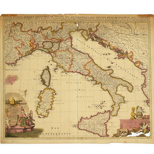
Sold2022Nicolas Sansom, map of Italy, 1701Nicolas Sansom, map of Italy, 1701, "L'Italie Divisee Suivant l'Estendue de Toutes ses Sourverainetes…", Pieter Schenk, Amsterdam, 1701, hand-colored copper plate engraving on laid paper, 20.25"See Sold Price
Sold2021Nicolas Sansom, map of Italy, 1701Nicolas Sansom, map of Italy, 1701, "L'Italie Divisee Suivant l'Estendue de Toutes ses Sourverainetes…", Pieter Schenk, Amsterdam, 1701, hand-colored copper plate engraving on laid paper, 20.25"See Sold Price
Sold2017Tanner: Map of Ireland, 1836Map: Map of Ireland Cartographer: Henry S. Tanner Date: 1836 Origin: Philadelphia Size: 11.8 x 9.4 inches A very attractive Tanner map of Ireland, hand colored by county and showing details for towns,See Sold Price
Sold2016Carey & Lea's 1822 Map of the United StatesDESCRIPTION: Carey & Lea's 1822 Map of the United States. Handcolored engraving on wove paper. Engraved by B. Tanner. Matted in wood frame. MEASUREMENTS: 17" x 21-1/2". Overall with frame 27-3/4" x 31See Sold Price
Sold2022[GREAT LAKES REGION]. A pair of engraved maps, including: T...[GREAT LAKES REGION]. A pair of engraved maps, including: TANNER, Henry Schenk. North America: Sheet V The Northwest and Michigan Territories. London Baldwin & Cradock, 1833. Hand–outlined in coSee Sold Price
Sold2021Antique 18th C Hand Colored Engraving Map AntillesAntique 18th Century Hand Colored Engraving Map of Antilles. Depicting the West Indies. Professionally framed and matted. Map measures 19 inches high x 23 inches wide. Frame measures 25.25 inches highSee Sold Price
Sold2022Hand-colored engraving Map of Egypt and surrounding Kingdoms, engraved by Tardieu, based on drawingHand-colored engraving Map of Egypt and surrounding Kingdoms, engraved by Tardieu, based on drawing by Lapie. Lots of toponymy. trade routes. Scales in leagues and in caravan journeys with heavy or liSee Sold Price
Sold202118TH / 19TH C HAND COLORED ENGRAVING MAP OF IRELAND18th / 19th century hand colored engraving map of Ireland. Marked in lower margin left and right "P.F. Tardieu Sculp" and "Andre Scrip". Framed measuring a total of 20.5" tall x 24" wide. Condition: vSee Sold Price
Sold2020Nicolas Sanson Atlantis Insula Map Hand Colored ENicolas Sanson (1600-1677), "Atlantis Insula," Amsterdam: Mortier, ca. 1700. This wonderful hand colored engraving map of America purportedly shows the Western Hemisphere about 200,000 years ago beforSee Sold Price
Sold2020Sanson Hand Colored Map of Europe Geographia SynGuillaume Sanson (1633-1703), "Geographia Synodica, Sive Regionum, Urbium, Et Locorum Ubi Celebrata Sunt Concilia," Paris, 1667. A hand colored engraving map of Europe depicting the places where ChurcSee Sold Price
Sold2020Abraham Ortelius Map of Scotland Britain 1590Abraham Ortelius (1527-1598), "Brittanicarum Insularum Vetus Descriptio," Antwerp, 1590. Hand colored engraving map of the British Isles featuring Scotland and the United Kingdom. The map appeared inSee Sold Price
Sold2022J. BARTHOLOMEW HAND-COLORED ENGRAVED MAP OF USJ. Bartholomew Hand-Colored Engraving Map of United States, Mid to Late 19th C. Hand-colored engraving on wove paper. Dimensions: (Frame) 18.0" W x 15.0" H x 1.0" D Condition: Creased in the center; nSee Sold Price
Sold2022ANTIQUE FRENCH NORMANDY MAPS ENGRAVINGS 17TH CEN.A pair of antique French hand-colored engravings maps. The first is titled, Le Pais De Cavx Normandy Part of Picardy. The Pais or Pays de Caux is a natural region of Normandy belonging to the Paris BaSee Sold Price
Sold20173 PC 19th c. HAND COLORED PA ENGRAVINGS + MAP1- Map of Pennsylvania from Johnson's Universal Cyclopedia c 1880s. Matted 19"x16". 2- Mauch Chunk and Mount Pisgah Hand Colored Wood engraving, 1872-74. Matted 12"x15". 3- The New Market Street BridgSee Sold Price
Sold2015Pair of Henry Fisher, Hand Colored MapsPublished by Henry Fisher, Caxton London. Each hand colored, one depicting British Dominions m North America, with date of 1823, and the other depicting North America with date of 1825. Each matted anSee Sold Price
Sold2021Van Geelkercken Orbis Terrarum Engraved MapNicholas (Nicolaes) van Geelkercken (Netherlandish, circa 1585-1656), "Orbis Terrarum Descriptio Duobis Planis Hemisphaeriis Comprehesa," hand-colored engraving / engraved map on laid paper, depictingSee Sold Price
Sold2020[Maps & Atlases] [Africa] Ortelius, Abraham, Group of 2[Maps & Atlases] [Africa] Ortelius, AbrahamGroup of 2 MapsBarbariae et Biledulgerid, nova descriptio(Antwerp, ca. 1570-1612). Hand-colored engraving. Coastal map of North Africa and the Mediterranean,See Sold Price
Sold20196 George Henry Mason colored engraving6 framed George Henry Mason hand colored engravings from the Costume of China, three with descriptive sheets from the book. These hand colored engraved plates are from Costumes of China by George HenrSee Sold Price
Jun 01Clark's Auction CompanyAntique Hand Colored Engraving, "Soldats de la Garde de Charles IX et Henry III."$20
4 days LeftTrillium Antique Prints & Rare BooksBraun & Hogenberg, pub. 1575 - View of Rimini, Italy$100(1 bid)
4 days LeftTrillium Antique Prints & Rare BooksBraun & Hogenberg, pub. 1575 - View of Szczecin (Stettin), Poland$100
4 days LeftTrillium Antique Prints & Rare BooksCatesby, Folio - Cecropia Moth with Custard Apple. 2-86$200
4 days LeftTrillium Antique Prints & Rare BooksBraun & Hogenberg, pub. 1575 - View of Lucca, Italy$100(1 bid)
4 days LeftTrillium Antique Prints & Rare BooksCatesby, Folio - Green Turtle with Turtle Grass. 2-38$200
4 days LeftTrillium Antique Prints & Rare BooksWilson - Roseate Spoonbill, Avoset, Plover, & Sandpiper. 63$75
4 days LeftTrillium Antique Prints & Rare BooksBraun & Hogenberg, pub. 1575 - View of Strasbourg, France$100
4 days LeftTrillium Antique Prints & Rare BooksBraun & Hogenberg, pub. 1575 - View of Orleans, France$100
4 days LeftTrillium Antique Prints & Rare BooksBraun & Hogenberg, pub. 1575 - View of Crete und Corfu$100
4 days LeftTrillium Antique Prints & Rare BooksCatesby, Folio - Nuthatch & Small Nuthatch with Highland Willow Oak. 1-22$200
4 days LeftTrillium Antique Prints & Rare BooksKohler - Timewheel with Volvule of the Kings and Dukes of Italy (Discus Chronologicus Regum$75


![Tanner's North America independent Texas: Heading: (North America) Author: Tanner, Henry Schenck Title: North America Place Published: Philadelphia Publisher: Date Published: 1836-[1845] Description: Engraved map, hand-colo](https://p1.liveauctioneers.com/642/319971/171838592_1_x.jpg?height=310&quality=70&version=1708136548)
![Tanner's North America independent Texas: Heading: (Texas) Author: Tanner, Henry Schenck Title: North America Place Published: Philadelphia Publisher: Date Published: 1836-[1845] Description: Engraved map, hand-colo](https://p1.liveauctioneers.com/642/171046/86179542_1_x.jpg?height=310&quality=70&version=1591835061)


![[GREAT LAKES REGION]. A pair of engraved maps, including: T...: [GREAT LAKES REGION]. A pair of engraved maps, including: TANNER, Henry Schenk. North America: Sheet V The Northwest and Michigan Territories. London Baldwin & Cradock, 1833. Hand–outlined in co](https://p1.liveauctioneers.com/928/252933/131521733_1_x.jpg?height=310&quality=70&version=1656110480)


![[Maps & Atlases] [Africa] Ortelius, Abraham, Group of 2: [Maps & Atlases] [Africa] Ortelius, AbrahamGroup of 2 MapsBarbariae et Biledulgerid, nova descriptio(Antwerp, ca. 1570-1612). Hand-colored engraving. Coastal map of North Africa and the Mediterranean,](https://p1.liveauctioneers.com/65/180189/90674454_1_x.jpg?height=310&quality=70&version=1601308774)


