Sold2022Herman Moll's New Map of the World - California as an Island!, Ca. 1725Herman Moll's New Map of the World - California as an Island!, Ca. 1725 1p, measuring 13.625" x 8.5", n.p., ca. 1725. A hand-colored map entitled "A New Map of the World according to the New ObservatiSee Sold Price
Sold2020MOLL, HERMAN. A Map of New France Containing Canada,MOLL, HERMAN. A Map of New France Containing Canada, Louisiana &c. in Nth America. Hand-colored engraved map of colonial North America. 7¾x10¾ inches sheet size, ample margins; mounted to foSee Sold Price
Sold2019Herman Moll 1654-1732), "A New And Correct Map of theHerman Moll 1654-1732), "A New And Correct Map of the World," 1710, hand colored, H. - 22 in., W. - 38 in.See Sold Price
Sold2020Grp: 5 Maps of Germany Europe and the MediterraneGroup of five 18th century maps. This group includes a hand colored map of Germany by Herman Moll (ca. 1654-1732); one map of the Turkish empire by Tobias Conrad Lotter (1717-1777); one map of the BriSee Sold Price
Sold2022Herman Moll 1701 Map of PolandThis quality matted and framed hand-colored bookplate map of Poland is from 1701 bt Herman Moll. The map itself measures 12" tall X 8" across.See Sold Price
Sold2024Herman Moll A New Map of Ye North Parts of AmericaHerman Moll (British, 1654-1732). Colored engraved map, A New Map of Ye North Parts of America Claimed by France Under Ye Names of Louisiana, Mississipi [sic], Canada & New France, With the AdjoiningSee Sold Price
Sold2022MOLL, HERMAN. A General Chart of the Sea Coast of Europe, Africa & America. According to E. Wright'sMOLL, HERMAN. A General Chart of the Sea Coast of Europe, Africa & America. According to E. Wright's or Mercator's Projection. Hand-colored engraved map of the Atlantic Ocean and continents adjacent.See Sold Price
Sold2023Herman Moll, Map of Bermuda, 1729Herman Moll, Map of Bermuda, 1729, "The Island of Bermudos Divided into its Tribes, with the Castles, Forts, &c", hand-colored engraving on paper, gallery stamps verso, matted and framed under glass,See Sold Price
Sold2018Herman Moll. Atlas Minor. Lon: Bowles, 1732.[Atlas] Herman Moll. Atlas Minor. Lon: Thos. Bowles & John Bowles, (1732). Engraved title + 50 of 62 maps with hand colored outline. Lacking maps 5, 8, 9, 19, 24, 27, 31, 49, 50, 51, 52, and 58. OblonSee Sold Price
Sold2023AMERICA H. Moll Geographer 1732 MapHerman Moll 1732 Map of the Americas, North and South America with California depicted as an island. Hand Colored engraving 8 1/2 x 11 in Matt.See Sold Price
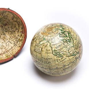
Sold2023(GLOBES.) Style of Herman Moll. A Correct Globe with the New Discoveries.(GLOBES.) Style of Herman Moll. A Correct Globe with the New Discoveries. 2¾-inch miniature terrestrial pocket globe comprised of 12 hand-colored engraved gores and 2 polar calottes on a plasterSee Sold Price
Sold2023HERMAN MOLL (ENGLISH, C. 1654-1732) MAP OF NORTH AND SOUTH CAROLINAHERMAN MOLL (ENGLISH, C. 1654-1732) MAP OF NORTH AND SOUTH CAROLINA, hand-colored engraving on laid paper, titled "CAROLINA / By / H. Moll Geographer" in a rectangular cartouche along lSee Sold Price
Sold2021H. Moll, 1714, A New Map of IrelandDedicated to Charles Duke of Shrewsbury. Constructed in 2 panels, hand colored. Tears to edges at folds and entire right edge. Staining and mold to right edge. 39-3/4" high x 25-1/4" wide. IMPORTANT:See Sold Price
Sold2019Moll, Herman 1724 Hand Coloured Map of Somerset"Somersetshire" Hand Coloured Copper Engraved Map Published 1724, London for "A New Description of England and Wales" by Hermann Moll. Paper Size: 12.5 x 8 inch (32 x 20cm) A few discrete wormholes, oSee Sold Price
Sold20231729 Map of New England, New York, Herman Moll1729 English Map of New England, Herman Moll (1654-1732). Map titled, "NEW ENGLAND NEW YORK NEW JERSEY and PENNSYLVANIA". Map with detailed depiction of the North East, with hand coloring. Good conditSee Sold Price
Sold2021A GROUP OF TWO 18TH CENTURY MAPS OF THE AMERICAS,A GROUP OF TWO 18TH CENTURY MAPS OF THE AMERICAS, LONDON AND PARIS, 1736-1780, two hand-colored engravings on paper, comprising, "FLORIDA Called by ye French LOUISIANA," after works by Herman Moll (16See Sold Price
Sold2023Two early maps in America and North America.Two early hand colored maps of New York State & North America including: The first, New Caldonia when it was still a colony of Scotland, dated 1699 - published by M. Moll - very good condition; and thSee Sold Price
Sold2017FRAMED WORLD MAP BY HERMAN MOLL, 1719'A New & Correct Map of the Whole World, by Herman Moll, Geographer, 1719.' Hand tinted and framed. Frame size: 73 x 124 cm (28 3/4 x 48 3/4 in.)See Sold Price
Sold2015Moll (Herman) - Virginia and Maryland,the Chesapeake Bay area, engraved map with original hand-colouring in outline, 275 x 210mm., 1729; with A Map of the British and French Plantations in North America, covering New England, Nova Scotia,See Sold Price
Sold2022HAND-COLORED MAP OF NEW JERSEY 16” x 13” sight. Framed 23” x 20”.HAND-COLORED MAP OF NEW JERSEYTogether with a framed miniature map of Northern California. “New Jersey” published by J.H. Colton, New York, 1855. Covering the region in great detail includSee Sold Price
Sold20231758 Bowen & Gibson 4 Atlas Minimus Maps1758 Bowen & Gibson Atlas Minimus Maps hand colored maps of New England, New York and Pennsylvania, Pennsylvania Maryland and Virginia, Carolina and Georgia. Beautiful small maps matted in acid free pSee Sold Price
Sold2018Hand Colored Antique Map Of New Amsterdam (New York)Map of the Original Grants of Village Lots from the Dutch West India Company to the inhabitant of New-Amsterdam, (now New-York) living below the present line of Wall Street. 19 1/2 x 17 in. (Framed),See Sold Price
Sold2022TWO HAND-COLORED MAPSTWO HAND-COLORED MAPS1) “A New Map of the West Indies”, J. Bayly. Published by Harrison & Co. for The Geographical Magazine, 1793. 9.5” x 16.75” sight. Framed 17.5” x 24.See Sold Price
Sold20231860 map of New Orleans by S. A. Mitchell, Jr.Vintage hand-colored map from Mitchell’s New General Atlas depicts the city of New Orleans. The heart of the city is shown in this colorful plan, with Bourbon and Canal Streets clearly marked. TSee Sold Price
4 days LeftThomaston Place Auction GalleriesHAND COLORED MAP OF PERU & COUNTRY OF THE AMAZONS, 1747, BY EMANUEL BOWEN, FRAMED$250
3 days LeftJasper52c1863 Civil War era Virginia with Washington D.C. and View of The Capital. By C. Magnus$220
157 Lots AwayTrillium Antique Prints & Rare BooksWarner's The Orchid Album - 11 Volumes with 526 Orchid Lithographs$4,900(1 bid)
147 Lots AwayTrillium Antique Prints & Rare BooksElliot & Keulemans - Black-and-white-Casque Hornbill$75


![Herman Moll A New Map of Ye North Parts of America: Herman Moll (British, 1654-1732). Colored engraved map, A New Map of Ye North Parts of America Claimed by France Under Ye Names of Louisiana, Mississipi [sic], Canada & New France, With the Adjoining](https://p1.liveauctioneers.com/7691/320359/172153415_1_x.jpg?height=310&quality=70&version=1708543789)


![Herman Moll. Atlas Minor. Lon: Bowles, 1732.: [Atlas] Herman Moll. Atlas Minor. Lon: Thos. Bowles & John Bowles, (1732). Engraved title + 50 of 62 maps with hand colored outline. Lacking maps 5, 8, 9, 19, 24, 27, 31, 49, 50, 51, 52, and 58. Oblon](https://p1.liveauctioneers.com/179/122672/62428326_1_x.jpg?height=310&quality=70&version=1527272450)