Sold2019Group of Early Maps of New Mexico(1) Rand, McNally & Co.'s New Commercial Atlas of America - Map of New Mexico. Copyright, 1911, by Rand, McNally & Co. 23 3/4 x 31 1/4 inches (2) Geologic Map of New Mexico. Two-part folding map. PartSee Sold Price
Sold2021Color map of California based on 1910 censusHeading: (California) Author: Title: Hammond's Complete Map of California Place Published: New York Publisher:C.S. Hammond & Co. Date Published: 1911 Description: Color foldingSee Sold Price
Sold20221911 Rand McNally Map of Texas [verso] Oklahoma -- [Texas] verso [Oklahoma]Title: 1911 Rand McNally Map of Texas [verso] Oklahoma -- [Texas] verso [Oklahoma] Cartographer: Rand McNally Year / Place: 1911 Chicago Map Dimension (in.): 9.2 X 12.5 in. This is a nice map of TexasSee Sold Price
Sold2019USA 1911 Lot of 8 State Maps. Encyclopaedia BritannicaIncl South Carolina, South Dakota, North Dakota, New Mexico, Connecticut, Oklahoma, Wyoming, and West Virginia. Lithograph Maps Published 1911, New York for "The Encyclopaedia Britannica" 11th EditionSee Sold Price
Sold2023Fontaine History of the New and Old TestamentFontaine, Nicolas. "History of the New and Old Testament" Second Edition, enlarged. Illustrated with 240 engraved images and 5 maps. London; R. Blome, et al, 1701. Full paneled calf with raised bandsSee Sold Price
Sold2020VINTAGE HAMMOND'S MAP OF EUROPE 18.5"H X 17"LVINTAGE HAMMOND'S MAP OF EUROPE 18.5"H X 17"L - NICELY MATTED IN PRETTY GOLD FRAMESee Sold Price
Sold201512 VOL SET-AUSTEN'S NOVELS, LEATHER SPINES, COPYRIGHT12 VOL SET-AUSTEN'S NOVELS, LEATHER SPINES, COPYRIGHT 1911, GOOD OVERALL CONDITION, AS PICTUREDSee Sold Price
Sold2019J Jesse McVicker Signed Color Aquatint [Abstract]J Jesse McVicker (Oklahoma 1911 - 2004) signed color aquatint. Signed and dated 'McVicker 53' in pencil lower right. Artist initial 'M' in plate lower left. Number '25/30' in pencil lower left. TitleSee Sold Price
Sold2018AN ADLAKE FANCY RAILROAD BASKET SHELF NO. 81An ornate antique basket shelf, all cast, as shown in 'Adlake Trimmings for Rail Cars and Steamships', copyright 1911, page 774. Measures 8 x 30 x 7.5 inches. We happily provide seamless in-house packSee Sold Price
Sold2023J. Jesse McVicker, Oklahoma (1911-2004), Untitled, 1978, oil on canvasJ. Jesse McVickerOklahoma, (1911-2004)Untitled, 1978oil on canvassigned and dated lower right, unframed.58 x 58 inchesSee Sold Price
Sold2019AN ANTIQUE MAP, "Map of Oklahoma and Indian Territory,"AN ANTIQUE MAP, "Map of Oklahoma and Indian Territory," 1890-1892, color engraving on paper, copyrighted by Mast, Crowell & Kirkpatrick, with view of Beaver. 10.375" x 13" Note: Showing populations oSee Sold Price
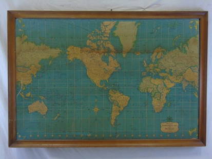
Sold2016Vintage Hammond's International Map of WorldVintage Hammond's International Map of the World. Prepared for the World Book Encyclopedia. 35" H x 51" W.See Sold Price
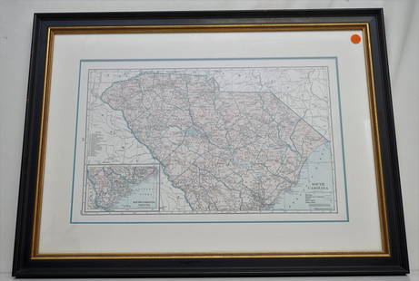
Sold2021HAMMONDS COMPLETE MAP OF SOUTH CAROLINAVintage Hammonds Complete Map of South Carolina. Showing all the railroad routes. c. 1930s. Professionally framed and matted. In frame measures 26 3/4"x20"x 1 1/4". Weight 7 pds. PROVENANCE: A PrivateSee Sold Price
Sold2022Vintage Travel Booklets, Maps and PamphletsApprox 16 pieces including vintage booklet and pamphlets include airport directory, Ford almanacs, AAA tour books for the southern USA, AAA travel books for Aruba and Mexico, Hammond's street map atlaSee Sold Price
Sold2020VINTAGE CANADIAN CLUB WHISKEY ADVERTISEMENT on HAMMONDsVINTAGE CANADIAN CLUB WHISKEY ADVERTISEMENT on HAMMONDs INT'L MAP of the WORLD Vintage CANADIAN CLUB WHISKY Advertisement on HAMMOND'S INTERNATIONAL MAP OF THE WORLD. Printed advertisement text in comSee Sold Price
Sold2018Vintage Formica Prototype Framed Map Of USAVintage Formica Prototype Framed Map Of USA w 1970’s articles about the development of Formica and laminate wall coverings. Map is titled Hammond’s Superior Map of the United States. Measures apprSee Sold Price
Sold2024HAMMOND'S READY REFERENCE HISTORICAL ATLAS 1920HAMMOND'S READY REFERENCE HISTORICAL ATLAS [A NEW SERIES OF 29 PLATES CONTAINING 67 COLORED MAPS] by Hammond, C.S.. Published by C.S. Hammond & Co, NY, circa 1920. Very good condition paperback.See Sold Price
Sold2015ERWIN S. CHRISTMAN AMERICAN 1882-1921Galloping Horses (1911), Bronze, 22.6 in (57.5 cm), inscribed E.S. Christman,1911, Kunst Foundary, NY- copyright 1922,See Sold Price
Sold2021WORLD WAR II POSTER "SAFEGUARDING OUR AMERICANLIBERTY", FRAMED AND UNDER PLASTIC. COPYRIGHT 1942. C S HAMMOND AND CO., NY. AFTER LAMBERT QUENTRER. 31 3/4" HIGH, 22" WIDE SIGHT SIZE. OVERALL 42 1/2" X 29".See Sold Price
Sold2022MAPS IN BOOK, Atlases, CareyCarey's Famous 1814 General Atlas. Atlases. Mathew Carey, Carey's General Atlas, Improved and Enlarged: Being a Collection of Maps of the World and Quarters, Their Principal Empires, Kingdoms, &c., 18See Sold Price
Sold2021Atq Map & Atlas Books, 1899 Spoffords & More - 1899Atq Map & Atlas Books, 1899 Spoffords & More - 1899 Maps Spofford's Cabinet Encyclopedia, 1906 Hammonds Pictorial Atlas of World w/ 1956 Hammond Double Day AtlasSee Sold Price
Sold2022Hammond Ambassador World Atlas, Gazetteer, 1stEd. 1957, Maps"Hammond's Ambassador World Atlas and Gazetteer?, published by C.S. Hammond, Maplewood, New Jersey, First Edition, Fifth Printing January 1957 [1st printing was issued July 1954] Hard boards, originalSee Sold Price
Sold2023George Catlin Indian Gallery [170312]This is a publication put out by the U.S. National Museum and authored by Thomas Donaldson. This 939 page book has an 1887 copyright. There are also several loose maps, showing the various tribal landSee Sold Price
Sold2017154 Easton Press Leather bound booksCollection of 154 leather bound books. Including, by The Easton Press, "The 100 Greatest Books Ever Written", collector's edition, all with tooled leather covers, copyright 1978. Titles: Moby Dick; CrSee Sold Price
2 days LeftCurated Gallery AuctionsHenry Hammond Ahl (1869 - 1953) Antique American Tonalist Forest Interior View Sunset Oil Painting$90(3 bids)
21 hrs LeftTrillium Antique Prints & Rare BooksCarey, pub. 1814 - Map of Hindostan or India$50(1 bid)
21 hrs LeftTrillium Antique Prints & Rare BooksCarey, pub. 1814 - Map of the East Indies with India, China, & New Holland (Australia)$50(1 bid)
21 hrs LeftTrillium Antique Prints & Rare BooksCarey, pub. 1814 - Map of New South Wales, Australia$50
5 days LeftJasper52British West Indies. Virgin Leeward Windward Islands. Bermuda. SWANSTON 1860 map$120
Trading Post AuctionsFramed Marilyn Monroe The Last Sitting 1962 By Bert Stern - Contact-sheet red Cross By Marilyn Mo...$600(2 bids)
6 days LeftHunt and Peck Estate Services, Inc.Two 1st Edition Books Theodore Dreiser 1912"The Financier" and 1911 "Jennie Gerhardt"$100
6 days LeftHunt and Peck Estate Services, Inc.1799 R. Griffiths Volume 30 Enlarged "The Monthly Review or LIterary Journal"$50
6 days LeftHunt and Peck Estate Services, Inc.1911 WIlliam Edgar Geil "Eighteen Capitals of China"$100


![1911 Rand McNally Map of Texas [verso] Oklahoma -- [Texas] verso [Oklahoma]: Title: 1911 Rand McNally Map of Texas [verso] Oklahoma -- [Texas] verso [Oklahoma] Cartographer: Rand McNally Year / Place: 1911 Chicago Map Dimension (in.): 9.2 X 12.5 in. This is a nice map of Texas](https://p1.liveauctioneers.com/5584/250444/130076930_1_x.jpg?height=310&quality=70&version=1654643749)


![J Jesse McVicker Signed Color Aquatint [Abstract]: J Jesse McVicker (Oklahoma 1911 - 2004) signed color aquatint. Signed and dated 'McVicker 53' in pencil lower right. Artist initial 'M' in plate lower left. Number '25/30' in pencil lower left. Title](https://p1.liveauctioneers.com/5755/146183/73867162_1_x.jpg?height=310&quality=70&version=1563394772)


![HAMMOND'S READY REFERENCE HISTORICAL ATLAS 1920: HAMMOND'S READY REFERENCE HISTORICAL ATLAS [A NEW SERIES OF 29 PLATES CONTAINING 67 COLORED MAPS] by Hammond, C.S.. Published by C.S. Hammond & Co, NY, circa 1920. Very good condition paperback.](https://p1.liveauctioneers.com/7983/318753/171113465_1_x.jpg?height=310&quality=70&version=1707443215)


![Hammond Ambassador World Atlas, Gazetteer, 1stEd. 1957, Maps: "Hammond's Ambassador World Atlas and Gazetteer?, published by C.S. Hammond, Maplewood, New Jersey, First Edition, Fifth Printing January 1957 [1st printing was issued July 1954] Hard boards, original](https://p1.liveauctioneers.com/6304/266436/140047426_1_x.jpg?height=310&quality=70&version=1668866616)
![George Catlin Indian Gallery [170312]: This is a publication put out by the U.S. National Museum and authored by Thomas Donaldson. This 939 page book has an 1887 copyright. There are also several loose maps, showing the various tribal land](https://p1.liveauctioneers.com/2699/299063/159201542_1_x.jpg?height=310&quality=70&version=1692045182)


