Sold2017Meyer: Antique Map, the Carolinas Georgia Florida, 1850Map: Die Staaten von N. & S. Carolina, Georgia & Florida Cartographer: Bibliographischen Instituts. Place & Date: Hildburghausen / 1850 Size: 7 3/4" x 10" Condition: original color; overall age toningSee Sold Price
Sold2017Bellin: Antique Map of Carolina & Georgia, 1757Map: Carte de la Caroline et Georgie Cartographer: Bellin Place & Date: Paris / 1757 Size: 11 1/8" x 7 3/8" Condition: b&w Bellin's highly detailed map of Georgia and the Carolinas with an elegant titSee Sold Price
Sold2017John Carey. North America map(English, 1754-1835). "Part of North America comprehending Ohio, New England, New York, New Jersey, Pennsylvania, Maryland, Virginia, Carolinas & Georgia" (sic) hand colored map, circa 1782, 9 1/2 x 1See Sold Price
Sold2017Tardieu: Antique Map of Florida & Georgia, 1798Map: Carte de la Floride et de la Georgie Cartographer: Chanlaire & Mentelle / Tardieu Place & Date: Paris / 1798 Size: 16 3/4" x 13" The dramatic Florida map, with Georgia and parts of the CarolinasSee Sold Price
Sold2017Bellin: Antique Map of the Carolinas and Georgia, 1757Map: Carte de la Caroline et Georgie Cartographer: Bellin Place & Date: Paris / 1757/1760 Size: 11 1/8" x 7 3/8" Condition: b&w; overall age toning; some spotting and staining; a tiny repaired puncturSee Sold Price
Sold2020Carte de la Caroline et Géorgie'. North/South CarolinaTITLE/CONTENT OF MAP: 'Carte de la Caroline et Géorgie [Map of the Carolinas and Georgia]' The top image on the right hand side shows the entire map. To view a close up of the map showing the level oSee Sold Price
Sold2018Bellin: The Carolinas, Georgia, North FloridaMap Title: Karte von den Kusten des Franzoisischen Florida Cartographer: Bellin Place & Date: Leipzig / 1756 Size: 5 3/4" x 8" Condition: b&w; light overall age toning Bellin's very interesting map ofSee Sold Price
Sold2020The Carolina’s with Georgia and parts of FloridaTitle: The CarolinaÂ’s with Georgia and parts of Florida Virginia. Important colonial era map. Date/Period: 1732/1736 Materials: Copper plate engraved Dimensions: 13 1/2 x 9” By. H. MOLL. FromSee Sold Price
Sold2020Map of a Part of New York, New Jersey, Pennsylvania,Title: Map of a Part of New York, New Jersey, Pennsylvania, Virginia, N. Carolina, S. Carolina, & Georgia. Publication Date: 1833 Cartographer: ANONYMOUS Size: 7.5Height - 6.1Width Showing the operatiSee Sold Price
Sold201718th Century Map of the Carolinas by Thomas Conder1788, London. The map features the Carolinas and part of Georgia including Savannah and Augusta. The piece is in good overall condition with some scattered wrinkles and fold lines consistent with ageSee Sold Price
Sold2021Carolina’s with parts of Georgia and Virginia, earlyTitle: Carolina’s with parts of Georgia and Virginia, early map of southern United States, by Bonne/ Raynal 1780 Date/Period: 1780 Materials: Copperplate engraved Size: 13 1/2 x 9 3/4'' Shows aSee Sold Price
Sold2016A NEW MAP OF NORTH AMERICA FROM 1763 DISCOVERIESPrinted on laid paper with Irish 1763 Pro Patria watermark of Detailed map of the British Colonies in North America at the close of the French & Indian War. The claims of the Carolinas, Virginia and NSee Sold Price
Sold201718th C. French Map w/ Oiled Paper, ex-Sotheby'sEurope, France, map from 1709 CE, oiled paper overlays from 1756 to 1763 CE, owned by Louis-Alexandre Berthier (1753 to 1815 CE), Marshal, Vice-Constable of France, and Chief of Staff (Major general)See Sold Price
Sold2021Antique French Map of MississippiAntique French Map of Mississippi , "Carte Geographique, Statistique et Historique du Mississipi", Paris, Buchon, 1825, sight 21 in. x 27 1/2 in., framed Provenance: Estate of Julia Evans ReedSee Sold Price
Sold2021Antique French Map of United States- Etats-Unis De L'Amerique Septentrionale Avec Les Isles Royale, De Terre Neuve, De St. Jean, L'Acadie &c.; Hand-colored; Ches Boudet Imprimeur du Roi; Paris; undated (circa 1785). One of the early maSee Sold Price
Sold2022Mannevillette French Map of the Indian Ocean, 1753D'APRES DE MANNEVILLETTE, Jean-Baptiste-Nicolas-Denis (1707-1780). [Indian Ocean] Carte Reduite de l'Ocean Oriental depuis le Cap de Bonne Esperance... Engraved map with original hand color in part. PSee Sold Price
Sold20241812 large French map of Paris plan routier de la Ville et faubourgLarge engraving of Paris and its surrounding area dated 1812 , cooper engraving in the manner of the Turgot map ,Jean Pierre printer , a Paris, chez Jean, Rue St Jean de Beauvais, N° 10, It is thSee Sold Price
Sold20221738 Antique French Map of North America1738 Antique French Map of North America, 1783 - Antique Map of North America, with documentation, This map is 221 years old - it is not a modern reproduction or copy, This map comes from: ATLAS DE TOSee Sold Price
Sold201718th Century French Map of North AmericaL’Amerique Septentrionale. Daniel de la Feuille (1640-1709). Engraved map with hand color in full. Amsterdam, 1702 or 1706. 6 x 8 inches visible, 13 x 14 1/2 inches framed. Nicely colored early 18thSee Sold Price
Sold2022c. 1788 French Map of the Eastern United StatesHistoric Maps c. 1788 Map, "Les Etats Unis de L'Amerique Septentrionale, Partie Orientale" (Eastern Part of the Northern United States of America) by M. (Rigobert) Bonne c. 1788 Map titled, "Les EtatsSee Sold Price
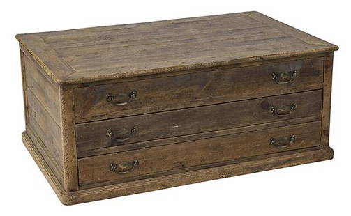
Sold2020Country French Map CabinetThree drawer case in pine with original brass hardware. Drawers pull out from both sides. 49w x 31 1/2d x 20 1/2hSee Sold Price
Sold2023Guillaume De L'Isle Philippe Buache Large Antique French Map of the AmericasImportant map of Guillaume de L'Isle corrected by Philippe Buache and edited by Dezauche in 1800 ,after the conclusion of the American revolutionary war and the treaty of Paris Dezauche updated the neSee Sold Price
Sold20211736 large French map of Paris and surrounding areaLarge engraving of Paris and its surrounding area dated 1736 , cooper engraving in the manner of the Turgot map , name of printer not lisible ,the date is clear . H.23 1/4 x W. 36 , suitable for framiSee Sold Price
Sold202118th C. French Map "Le Noveau Mexique …"Ribobert Bonne (French, 1727-1794). "Le Nouveau Mexique, Avec La Partie Septentrionale De L'Ancien, ou De La Nouvelle Espagne" Published in Paris, 1780. Among the most collected late 18th century mapsSee Sold Price
6 days LeftJasper52Large Antique French map GERMAN EMPIRE 1792 colored by POIRSON engraver Basset$170
Jun 09Worthington GalleriesAntique H/C Map EUROPE SOUS CHARLEMAGNE EN 814: EMPIRES D'OCCIDENT ET D'ORIENT$25
6 days LeftJasper521770 French engraving map of Bonne,Rigobert Arabie. Mer Rouge et Golfe Persique$95
Jun 20The Ross Art GroupOriginal Vintage Air France World Route Map Vickers Viscount Poster 1956 Constellation$600


![Carte de la Caroline et Géorgie'. North/South Carolina: TITLE/CONTENT OF MAP: 'Carte de la Caroline et Géorgie [Map of the Carolinas and Georgia]' The top image on the right hand side shows the entire map. To view a close up of the map showing the level o](https://p1.liveauctioneers.com/5584/182355/91727171_1_x.jpg?height=310&quality=70&version=1603285541)


![Mannevillette French Map of the Indian Ocean, 1753: D'APRES DE MANNEVILLETTE, Jean-Baptiste-Nicolas-Denis (1707-1780). [Indian Ocean] Carte Reduite de l'Ocean Oriental depuis le Cap de Bonne Esperance... Engraved map with original hand color in part. P](https://p1.liveauctioneers.com/1968/250616/130196497_1_x.jpg?height=310&quality=70&version=1654190895)