Sold2023Williamson, Lieut. R. S. 1856 LG Chart. California - Coast Mountains & Sierra Nevada"Geological Section of the Coast Mountains and Sierra Nevada" by W. P. Blake. Lithograph Map Published 1853-61, Washington for "Reports of explorations and surveys, to ascertain the most practicable aSee Sold Price
Sold20191872 1st ed Exploration Arizona Nevada California1872 1st ed Exploration Arizona Nevada California Mojave George Wheeler Survey The first official exploration report on the Mojave and Death Valleys! (Howes) George Wheeler was a 19th-century AmericanSee Sold Price
Sold20191856 RAILROAD Exploration Surveys Navajo Indians1856 RAILROAD Exploration Surveys Navajo Indians Arizona Fossils RARE Beginning in 1855, the United States Congress published reports and surveys of certain railroad routes from the Mississippi RiverSee Sold Price
Sold20231855 Beckwith Map of Nevada -- Map No. 3 From the Humboldt Mountains to the Mud Lakes fromTitle: 1855 Beckwith Map of Nevada -- Map No. 3 From the Humboldt Mountains to the Mud Lakes from Explorations and Surveys Made Under the Direction of Hon. Jefferson Davis, Sec. of War… CartograSee Sold Price
Sold20231855 Beckwith Map of Nevada and Northern California -- Map No. 4 From the Valley of the Mud Lakes toTitle: 1855 Beckwith Map of Nevada and Northern California -- Map No. 4 From the Valley of the Mud Lakes to the Pacific Ocean from Explorations and Surveys Made Under the Direction of Hon. Jefferson DSee Sold Price
Sold20231855 Beckwith Map of Northern Utah and Nevada -- Map No. 2 From Great Salt Lake to the HumboldtTitle: 1855 Beckwith Map of Northern Utah and Nevada -- Map No. 2 From Great Salt Lake to the Humboldt Mountains from Explorations and Surveys Made Under the Direction of Hon. Jefferson Davis, Sec. ofSee Sold Price
Sold20221855 Beckwith Map of Northern Utah and Nevada -- MapTitle: 1855 Beckwith Map of Northern Utah and Nevada -- Map No. 2 From Great Salt Lake to the Humboldt Mountains from Explorations and Surveys Made Under the Direction of Hon. Jefferson Davis, Sec. ofSee Sold Price
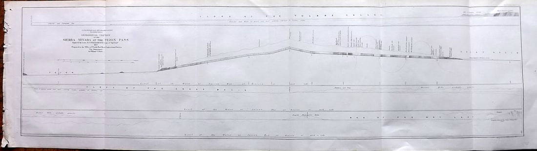
Sold2023Williamson, Lieut. R. S. 1856 LG Chart. California - Sierra Nevada & Tejon Pass"Goelogical Section of the Sierra Nevada at the Tejon Pass" by R. S. Williamson. Lithograph Map Published 1853-61, Washington for "Reports of explorations and surveys, to ascertain the most practicablSee Sold Price
Sold2017Exploration and Survey of the Valley of the Great SaltExploration and survey of the valley of the Great Salt Lake of Utah. UTAH. Howard Stansbury. Lippincott, Grambo & Co. 8vo, 487 p. map, 57 plts. Embossed purple cloth, spine damaged, lacks rear endpapeSee Sold Price
Sold2023Williamson, Lieut. R. S. 1856 Map. Vicinity of San Francisco California"Geological Map of the Vicinity of San Francisco" by William P. Blake. Lithograph Map Published 1853-61, Washington for "Reports of explorations and surveys, to ascertain the most practicable and econSee Sold Price
Sold2023Williamson, Lieut. R. S. 1856 HC Map. San Diego & Colorado River California"Geological Map of the Country Between San Diego and the Colorado River California" By W. P. Blake. Hand Colored Lithograph Map Published 1853-61, Washington for "Reports of explorations and surveys,See Sold Price
Sold2023Williamson, Lieut. R. S. 1856 LG Chart. California - Colorado River to the Pacific Ocean"Geological Section from the Colorado River to the Pacific Ocean" by William P. Blake. Lithograph Map Published 1853-61, Washington for "Reports of explorations and surveys, to ascertain the most pracSee Sold Price
Sold2021Stansbury's Exploration Great Salt Lake 1853Exploration and Survey of the Valley of the Great Salt Lake of Utah… Washington: Armstrong, 1853. 8vo. 495 p. 54 plates (2 are oblong folding). Some pages and binding loose. Spine and boards sunnedSee Sold Price
Sold2021Early California/Nevada Desert Survey Maps (17)A group of 17 maps that chart the areas of desert in eastern California and Nevada. Sixteen of the maps measure 21"x 16" and one, showing the Kingman, Arizona and California southern desert regions meSee Sold Price
Sold2024Explorations & Surveys West of the One Hundredth Meridian [178529]1875 Report Upon Geographical and Geological Explorations and Surveys West of the One Hundredth Meridian by Humphreys. 1021pp, 45 plates, many in color. Based on explorations 1871-74. Sections on mammSee Sold Price
Sold2019US Pacific Railroad Explorations & SurveysGroup of 37 lithograph plates From "Reports of Explorations and Surveys, to ascertain the most practicable and economical route for a railroad from the Mississippi River to the Pacific Ocean, made undSee Sold Price
Sold2018(4) Explorations & Surveys Chromolithographs PacificAll in this lot are 47th & 49th parallels by John Mix Stanley. This collection contains: FLATHEAD LAKE (LOOKING SOUTHWARD), HOT SPRINGS AT THE SOURCE OF LOU LOU (BITTER ROOT MOUNTAINS, LOOKING WEST),See Sold Price
Sold2018(4) Explorations & Surveys Chromolithographs PacificAll in this lot are 47th & 49th parallels by John Mix Stanley. This collection contains: PIKE LAKE, LAKE JESSIE, BOIS DE SIOUX RIVER, & MILK RIVER & PANTHER MOUNTAIN. These were part of collection madSee Sold Price
Sold20184) Explorations & Surveys Chromolithographs PacificAll in this lot are the 35th parallel. This collection contains: VIEW OF THE BLACK FOREST & SIERRA PRIETA, ZUNI SACRED SPRING, BIVOUAC, JAN. 26, & A CONICAL HILL, 500 FT HIGH.. These were part of collSee Sold Price
Sold2018(4) Explorations & Surveys Chromolithographs PacificAll in this lot are 38th & 39th parallels by John Mix Stanley after RH Kern. This collection contains: ROCK HILLS BETWEEN GREEN & WHITE RIVERS, PEAKS OF THE SIERRA BLANCA, COO-CHE-TO, SUMMIT OF NEARESSee Sold Price
Sold2018(6) Explorations & Surveys Chromolithographs PacificVarious parallels by different artists. This collection contains: WAH-HA-TA-GAS OR SPANISH PEAKS,SANGRE DE CRISTO PASS LOOKING TOWARDS SAN LUIS VALLEY, VIEW OF ORDINARY LATERAL RAVINES ON GRAND RIVER,See Sold Price
Sold20191860 RAILROAD Exploration Surveys Plants Insects Mammal1860 RAILROAD Exploration Surveys Plants Insects Mammals Birds Reptiles Fish Beginning in 1855, the United States Congress published reports and surveys of certain railroad routes from the MississippiSee Sold Price
Sold20191855 RAILROAD Exploration Surveys Navajo Indians1855 RAILROAD Exploration Surveys Navajo Indians Colorado Fossils RARE American Beginning in 1855, the United States Congress published reports and surveys of certain railroad routes from the MississiSee Sold Price
Sold2022Exploration & Survey Reports Volume 12 Book 1This copy of House of Representatives Exploration & Survey Reports Mississippi River to the Pacific Ocean 1853-1855 is Volume 1, Book 1, with 70 tinted engraved illustrations, with foldouts, WashingtoSee Sold Price
6 days LeftSchilb Antiquarian Rare Books1856 California 1ed John Fremont Exploration Memoirs Oregon Trail Nevada Indians$56(4 bids)
May 15University ArchivesEarly Arctic Exploration: "Journal of a Voyage for the Discovery of a North-West Passage" by William$500
6 days LeftSchilb Antiquarian Rare Books1892 EGYPT Exploration 1ed Osorkon II Festival Bubastis Archaeology Hieroglyphs$17(3 bids)
Jun 02Schilb Antiquarian Rare Books1856 Fremont Illustrated American Exploration California Rocky Mountains Smucker$1
2 days LeftTiberius AuctionsLiganda or Ngbele, pre-coinage means of payment or bride price, so-called sword money€100
13 hrs LeftHudson Valley Auctioneers LLC Beacon NYPatent Model, Velocipedes" (bicycle), by P Denham, 1879, original label, model is incomplete,$150(3 bids)
May 18Fontaine's Auction GalleryCharles P. Limbert Co. Rocking Chair, No. 842 & Armchair, No. 841$2,200


![Explorations & Surveys West of the One Hundredth Meridian [178529]: 1875 Report Upon Geographical and Geological Explorations and Surveys West of the One Hundredth Meridian by Humphreys. 1021pp, 45 plates, many in color. Based on explorations 1871-74. Sections on mamm](https://p1.liveauctioneers.com/2699/324084/174414763_1_x.jpg?height=310&quality=70&version=1711485923)


