Sold2018Vandermaelen: Antique Map of Poland Czechia SlovakiaTitle/Content of Map: 'Europe - Partie de l'Allemagne - No 14 ' Poland south of Olsztyn, Czechia, Slovakia, and parts of Austria & Western Ukraine Date Printed: 1827 Image Size: Approx 71.0 x 52.0cm,See Sold Price
Sold2019Abraham Ortelius (Belgian, 1527-1598) Map of Poland.Abraham Ortelius (Belgian, 1527-1598) Map of Poland. Engraving 14.5" x 19" Frame: 23" x 27.25"See Sold Price
2017Carte Politique Et Itineraire De L'Europe...1807 map of Europe: “CARTE POLITIQUE ET ITINÉRAIRE DE L'EUROPE ET DE L'EMPIRE FRANCAIS EN 1807 “by Hyacinthe Langlois. Measurement approximate: 19” x 14.5”. Please note that this lot has a coSee Sold Price
Sold2024French Map of America Southwest & Mexico [179298]French map the American Southwest and Mexico. This is a double truck from an 18th century book and measures 10x 14". Map from 1787 during the reign of Louie XVI the king France who beheaded in1793.RivSee Sold Price
Sold2016Erna ROSENSTEIN (1913-2004) Ukraine - PolandErna ROSENSTEIN (1913-2004) Abstract ; the second quarter of the 20th century oil on canvas ; unframed dimensions: 213 x 153 cm (83 7/8 x 60 1/4 in.) signed lower right expensive shipping - ask aboutSee Sold Price
Sold2024Gerard Mercator (Belgian 1512 - 1594) and Rumold Mercator (Belgian 1545 - 1599)Gerard Mercator (Belgian 1512 - 1594) and Rumold Mercator (Belgian 1545 - 1599) "Orbis Terrae Compendiosa Descriptio", circa 1595 Engraved and hand colored map 14 1/2" x 19 3/4" Condition: aging, yellSee Sold Price
Sold2023Prémière partie de la carte d'Europe'. D'ANVILLE. Western Europe 1756 old mapTITLE/CONTENT OF MAP: 'Prémière partie de la carte d'Europe contenant La France, L'Alemagne, L'Italie, L'Espagne, & les Isles Britanniq.s. Publiée sous les auspices de Monseigneur LouisSee Sold Price
Sold20241586-KB & 1625 1/4 [2] Denar & Poland ANACS AU/VF1586-KB & 1625 1/4 [2] Denar & Poland ANACS AU/VFSee Sold Price
Sold202414 Rare Vintage Maps of Northern MN Lakes & Canada24" x 30" and smaller. Canadian Dep. of Mines & Resources 1939 map of Sioux Lookout, 1942 map of Quetico Ontario, 1939 map of Kenora Manitoba-Ontario, 1948 map of Ponite-Dubois Manitoba-Ontario, 1940See Sold Price
Sold2022Christo, Wrapped Reichstag, Project for BerlinChristo Wrapped Reichstag, Project for Berlin 1994collage with pencil, enamel paint, photograph by Wolfgang Volz, crayon, charcoal, map and tape on panel 14 h × 11 w in (36 × 28 cm)See Sold Price
Sold2022[WEST FLORIDA] CHESTER, PETER. Three crudely printed land grants for West Florida, engrossed in[WEST FLORIDA] CHESTER, PETER. Three crudely printed land grants for West Florida, engrossed in manuscript, each with an attached manuscript survey map. Pensacola, Florida: 11 January, 14 November andSee Sold Price
Sold2016JOHN SPEED (BRITISH, 1552-1629) MAP OF THE WORLDJOHN SPEED (BRITISH, 1552-1629) MAP OF THE WORLD, (UPDATED 6/14/16) hand-colored engraving on laid paper, titled "A New and Accurat Map of the World Drawne according to ye truest Descriptions latest DSee Sold Price
Sold2024VOLTA ALESSANDRO: (1745-1827) 'To tell the truth, the author's idea of relating electrical phenomenaVOLTA ALESSANDRO: (1745-1827) 'To tell the truth, the author's idea of relating electrical phenomena to chemistry is beautiful, it is great and should lead to truth, but such a conception is singularlSee Sold Price
Sold2022ISAAC (ITSHAK) HOLTZ, PolandISAAC (ITSHAK) HOLTZPoland/America, 1925-2018"Snow Scene". Signed lower right "I Holtz". Titled and dated "New-York 1961" verso.Oil on board, 9.25" x 20.75". Framed 14.75" x 26.25".See Sold Price
Sold2017Vandermaelen, Atlas universel de géographie...Vandermaelen Philippe, Atlas universel de géographie physique, politique, statistique et minéralogique [...]. Première [-sixiéme] partie. Bruxelles: s.e., 1827. 6 volumi in-folio (mm 525x750). PSee Sold Price
Sold2024Antique TC Lotter Magni Turcarum Dominatoris Map19.5 X 22.5 Antique map by famous German cartographer Tobias Conrad Lotter of the Turkish empire, Magni Turcus Dominatoris Imperium. Shows regions of Europe, Asia, and Africa. Original publication donSee Sold Price
Sold2024Ohio copy of Mathew Carey’s 1796 GENERAL ATLASCarey, Mathew (publisher). CAREY’S GENERAL ATLAS. Philadelphia: Printed by Mathew Carey, May 1, 1796. FOLIO (14.75 x 9.5 inches), COMPLETE AS PUBLISHED (including a Rare Map of The United States bySee Sold Price
Sold2018JOSEPH RUSLING MEEKER (American 1827-1889) A PAINTING,JOSEPH RUSLING MEEKER (American 1827-1889) A PAINTING, "Near Bayou Plaquemines, LA," oil on canvas, dated and signed L/L, titled, placed, and monogramed verso. 18" x 14"See Sold Price
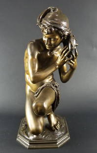
Sold2018Late 19th C. Patinated Bronze Figure Jeune Pecheur "ALate 19th C. Patinated Bronze Figure Jeune Pecheur "A La Coquille", by Jean Baptiste Carpeaux, French 1827-1875 Susse Freres Foundry, Paris Circa 1880. Measures H: 24 1/4" W: 10" Depth: 14"See Sold Price
Sold2024Pablo Picasso Spanish 1881 1973 Oil On Canvas Painting Dali , Magritte , Braque Juan Gris Cubism EraThis oil painting on canvas depicts a portrait of a woman with an elongated nose. Measuring 16 x 14 inches, the artwork is part of a private collection in Europe and is presented within a frame. The aSee Sold Price
Sold2016Diamante rotondo taglio a brillante vecchio europeo diDiamante rotondo taglio a brillante vecchio europeo di ct 2,94, g. 14,90 misura 12/52 Accompagnato da analisi gemmologica CISGEM n. 2593IAAB Milano del 08/02/2016 Old Europe cut diamond Appended CISGESee Sold Price
Sold2024Bactrian Style Lapis Lazuli Bead Necklace20th century A.D. Restrung with coin-shaped and annular beads, granulated metal collars. 35 grams, 47 cmn (18 1/2 in.). Acquired on the London, UK, art market in the 1990s. Ex London, UK, gallery. [NoSee Sold Price
Sold2022China Ming Dynasty A large vat with dragon pattern in blue and white Xuande periodChina Ming Dynasty A large vat with dragon pattern in blue and white Xuande periodSee Sold Price
Sold2022《 Sedan Chair 》 Oil on canvas ( by Frederik Hendrik Kaemmerer , 1839-1902 , France )《 Sedan Chair 》 Oil on canvasby Frederik Hendrik Kaemmerer 1839-1902 France the paiting was published in the London Journal in 1886 we offering the publicationSee Sold Price
Jun 18DOYLE Auctioneers & AppraisersSet of Twelve Satirical Anthropomorphic Maps of Europe$400(1 bid)
2 days LeftAustin Auction Gallery(2) AFTER CHARLES GABRIEL LEMIR PATINATED BRONZE SCULPTURES OF CUPID$450(1 bid)
7 days LeftApple Tree Auction CenterLot of (2) Framed Vintage Maps Washington 24 x 30 in. (61 x 76.2 cm.), Carlisle 21 1/4 x 17 in. (54$5


![French Map of America Southwest & Mexico [179298]: French map the American Southwest and Mexico. This is a double truck from an 18th century book and measures 10x 14". Map from 1787 during the reign of Louie XVI the king France who beheaded in1793.Riv](https://p1.liveauctioneers.com/2699/331495/178785763_1_x.jpg?height=310&quality=70&version=1717094933)


![1586-KB & 1625 1/4 [2] Denar & Poland ANACS AU/VF: 1586-KB & 1625 1/4 [2] Denar & Poland ANACS AU/VF](https://p1.liveauctioneers.com/7261/327268/176925015_1_x.jpg?height=310&quality=70&version=1715195040)


![[WEST FLORIDA] CHESTER, PETER. Three crudely printed land grants for West Florida, engrossed in: [WEST FLORIDA] CHESTER, PETER. Three crudely printed land grants for West Florida, engrossed in manuscript, each with an attached manuscript survey map. Pensacola, Florida: 11 January, 14 November and](https://p1.liveauctioneers.com/292/250642/130213768_1_x.jpg?height=310&quality=70&version=1654271664)


![Vandermaelen, Atlas universel de géographie...: Vandermaelen Philippe, Atlas universel de géographie physique, politique, statistique et minéralogique [...]. Première [-sixiéme] partie. Bruxelles: s.e., 1827. 6 volumi in-folio (mm 525x750). P](https://p1.liveauctioneers.com/1306/98757/50319563_1_x.jpg?height=310&quality=70&version=1483624314)


![[MAP]. ORTELIUS, Abraham. Romani Imperii Imago. 1592. (1 of 2)](https://p1.liveauctioneers.com/197/329395/177650537_1_x.jpg?height=282&quality=70&version=1715364962)


