Sold2020Encyclo. Britannica C1830 Map of East Indies & Burma"Eastern Islands, Birmah &c" Steel Engraved Map Published 1830-42, Edinburgh for "Encyclopedia Britannica" Seventh Edition. Centre fold as issued. Paper Size: 16 x 11 inch (40 x 28cm) Good conditionSee Sold Price
Sold2019MAP - East Indies - Indonesia. TirionEast Indies - Indonesia. Isaac Tirion, Kaart van de Papoasche Eilanden, 1753 (dated). Hand Color. This beautifully engraved chart spans from the Spice Islands (Sallawatty, Patenta, Gammen, Land van WaSee Sold Price
Sold2024East India islands & Indochina. Dutch E. Indies. Philippines. THOMSON 1817 mapTITLE/CONTENT OF MAP: East India Isles [and Birman Empire] A large map of the Dutch East Indies, Indochina and the Philippines. "Pinang" (Penang), "Bankok" (Bangkok), "Manilla" (Manila), and the StraiSee Sold Price
Sold2018Johnson: Antique Map of Australia & East Indies, 1867Title/Content of Map: Australia, islands of Indonesia, New Guinea & Philippines. Insert of New Zealand Date Printed: 1867 Cartographer: Johnson Material/Medium: Paper Size: 18" x 26 1/2" Please note tSee Sold Price
Sold2016Ortelius map of East Indies 1570Heading: Author: Ortelius, Abraham Title: Indiae Orientalis Insularumque Adjacientium Typus Place Published: [Antwerp] Publisher: Date Published: 1570- Description: Copper-engraSee Sold Price
Sold2015De Bry (Theodore) - Descriptio Hydrographicathe 2-sheet map of Africa and Asia, from the east coast of Brazil to Japan, charting the first Dutch voyage to the East Indies by Houtman, large titlecartouche upper centre of right sheet, ships, compSee Sold Price
Sold2023Rare 1925 Map of The Town and Harbor of Nantucket by Phillip L. HallRare 1925 Map of The Town and Harbor of Nantucket by Phillip L. Hall, whimsical map showing the town, harbor, ships, aircraft, and prominent landmarks of the island. Overall 23 in. x 15 in.See Sold Price
Sold2022Toraja Tau Tau Male and Female SculpturesSulawesi Island, Indonesia, 19th/20th century, comprising: two carved and stained wooden figures, one male and one female, painted in black, blue, and red pigment, metal appliques to foreheads, both wSee Sold Price
Sold2022Roy Lichtenstein (1923-1997); Guild Hall East Hampton;Roy Lichtenstein (1923-1997) Guild Hall East Hampton, 1980 Screenprint in colors with text on wove paper, signed in pencil, dated and numbered 115/200 on the reverse (there was also an unsigned editioSee Sold Price
Sold2024Roy Lichtenstein Serigraph 'Guild Hall'Roy Lichtenstein, American (1923-1997). 1980's Silkscreen reproduction of original painting 'Landscape' 1974, 'Guild Hall East Hampton'. Signed and dated 1980 lower right in pencil. Mounted in white fSee Sold Price
Sold201715th C. Majapahit Piggy Bank - Filled w/ Coins!Indonesia, East Java, Majapahit Dynasty, ca. 15th century CE. Perhaps one of the earliest piggy banks, a corpulent pig - in actuality a Javanese boar or celeng (a petite black-skinned, swayed back relSee Sold Price
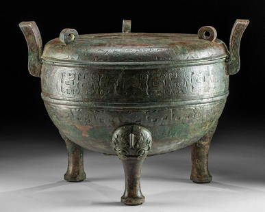
Sold2022Chinese Eastern Zhou Dynasty Lidded Bronze DingEast Asia, China, Eastern Zhou Dynasty, ca. 5th to 4th century BCE. A stunning and large leaded bronze ritualistic cauldron known as a ding vessel with a matched lid standing on elegant tripodal legs.See Sold Price
Sold2018Chinese Wei / Qi Carved Stone Bodhisattva GuanyinEast Asia, China, Eastern Wei or Northern Qi Dynasty, ca. mid 6th century CE. A fascinating limestone sculpture of the bodhisattva Guanyin (Avalokiteshvara), "The Lord Who Gazes Down At The World." ThSee Sold Price
Sold2024Chinese Carved Coral Birds Avian SculptureChina,Early 20th Century Carved coral depicting birds perched on cherry blossom branches mounted in a carved wood base. Coral From the collection of an East Providence, Rhode Island estate. Approx. 8"See Sold Price
Sold2022Middle East.- Saudi Arabia.- Saudi Aramco (publisher) Collection of maps and ephemera from compiledMiddle East.- Saudi Arabia.- Saudi Aramco (publisher) and others. Collection of maps and ephemera compiled by a British Engineer working in the Middle East, including 5 laminated maps of Saudi Arabia,See Sold Price
Sold2022Booth, Charles Labour and Life of the PeopleBooth, Charles Labour and Life of the People Volume I: East London. Second Edition. With a Coloured Map. [Together with:] Volume II: London Continued. With Maps and Appendix under a Separate Cover. LoSee Sold Price
Sold2019Herreshoff Museum Bluefish Sailboat C. 1916The Herreshoff Fish Class sailboat Bluefish (HMCo. #790), from the collection of the Herreshoff Marine Museum / America's Cup Hall of Fame in Bristol, Rhode Island. The vessel, one of the first groupSee Sold Price
Sold2023WWII U.S. MILITARY FIELD MAPS 1939-1945 - (4)170301 WWII U.S. MILITARY FIELD MAPS 1939-1945 - (4) WWII U.S. military field maps 1939- 1945 to include one East and West Omaha beach scanned "Bigot" Field maps, one France (12500) Isigny field map,See Sold Price
Sold2022Qing Dynasty Red Sandalwood Inlaid Jasper Blessed East SeaL:88.5cm H:60cm Wt:8400gSee Sold Price
Sold2024Map of United States of North America, 1785Map of United States of North America, 1785, The Royal Islands of Newfoundland. 26 3/4 x 32 3/4 in framed. 19 x 25 in unframed.Local Pick up call one day before to make an appointment. TO SHIP THIS ITSee Sold Price
Sold2022DES BARRES, JOSEPH FREDERICK WALLET The North East Shore of the Gulph of Mexico. London: circa 1780.DES BARRES, JOSEPH FREDERICK WALLET The North East Shore of the Gulph of Mexico. London: circa 1780. A very large hand-colored engraved map on four joined sheets. Overall 30 x 84 inches (76 x 214 cm).See Sold Price
Sold2023Original Vintage Indochine Francaise Map by Lucien Boucher 1935 Vietnam Laos CambodiaAs one can only imagine, travel in the Far East in the 1920's must have been a challenging adventure. This well illustrated map poster by master artist, Lucien Boucher shows the various routes once coSee Sold Price
Sold2024Ancient Near Eastern Steatite Falcon Amulet, c. 1200-539 BCECategory: Pendants and Figurines Carved from steatite, this amulet depicts a falcon, a symbol of divine protection and power in the ancient Near East. Dating from the Iron Age to the Neo-Assyrian PeriSee Sold Price
4 days LeftTrillium Antique Prints & Rare BooksPrevost - Pair of Engravings of Chinese Boats or Junks$50
2 days LeftZikorn Arts & History ObjectsWest Indies, Eastern Cuba 1881 British Admiralty Nautical Map$100
1 day LeftJasper52Dalmatia, Istria, Bosnia, Servia, Croatia… ROSSI / CANTELLI DA VIGNOLA 1684 map$260
2 days LeftZikorn Arts & History ObjectsWest Indies, Western Cuba 1879 British Admiralty Nautical Map$100
105 Lots AwayAkiba Galleries(2 Pc) Allain Manesson Mallet Description De L'Univers 2 Vol. German Translation$200(1 bid)
Featured6 hrs LeftJasper521744 Bowen Map of Europe -- A New and Accurate map of Europe Drawn from the Best Authorities,$110
Jun 07Freeman's | HindmanBELLIN, Jacques-Nicolas. Carte Reduite de L'Ocean Oriental ou Mer Des Indies. Paris, 1757. Second$150
Featured1 day LeftJasper52Chart of the Sea Coasts of England, Flanders & Holland. MOUNT & PAGE 1758 map$420
3 days LeftThousand Planet Auction HouseAn Ancient Near Eastern Uruk Period Steatite Linear Stamp, c. 3300-3100 BCE$10
1 day LeftJasper52Corso del Danubio da Belgrado fino al Mar Ner. Danube. ROSSI / CANTELLI 1684 map$160


![East India islands & Indochina. Dutch E. Indies. Philippines. THOMSON 1817 map: TITLE/CONTENT OF MAP: East India Isles [and Birman Empire] A large map of the Dutch East Indies, Indochina and the Philippines. "Pinang" (Penang), "Bankok" (Bangkok), "Manilla" (Manila), and the Strai](https://p1.liveauctioneers.com/5584/320546/172232433_1_x.jpg?height=310&quality=70&version=1709072904)

![Ortelius map of East Indies 1570: Heading: Author: Ortelius, Abraham Title: Indiae Orientalis Insularumque Adjacientium Typus Place Published: [Antwerp] Publisher: Date Published: 1570- Description: Copper-engra](https://p1.liveauctioneers.com/642/86438/44449716_1_x.jpg?height=310&quality=70&version=1458591928)


![Booth, Charles Labour and Life of the People: Booth, Charles Labour and Life of the People Volume I: East London. Second Edition. With a Coloured Map. [Together with:] Volume II: London Continued. With Maps and Appendix under a Separate Cover. Lo](https://p1.liveauctioneers.com/94/251108/130828910_1_x.jpg?height=310&quality=70&version=1655281539)


