Sold20181869 Map of East Granby CTDescription: 1869 Map of East Granby Connecticut. Measurement approximate: 18 x 14. Shipping cost: $15.00 excluding Hawaii, Alaska and CaliforniaSee Sold Price
Sold2023Grouping of Antique Naugatuck CT Maps & AtlasDescription: This lot includes a small grouping of antique 19th century historical items from Naugatuck CT. Included is a 1893 Topographical Atlas of CT, Price & Lee Co's map of Naugatuck CT fSee Sold Price
Sold2021Antique Map of Bedford, CTDescription: This lot includes an antique map of Bedford, CT. Map is unsigned, undated and unframed. Condition: Map is in overall good condition with some damage to the edges. Location: Lot is locatedSee Sold Price
Sold2024North East Africa. Egypt Abyssinia Arabia Abu Dhabi Sharja. COLTON 1869 mapTITLE OF MAP (NOT PRINTED ON THE PAGE):'Africa - north eastern sheet' DATE PRINTED: 1869 IMAGE SIZE: Approx 42.0 x 33.5cm, 16.5 x 13.25 inches (Large) TYPE: Antique engraved hand coloured atlas map COSee Sold Price
Sold2022Vtg. Map of Tappan Sea - Westchester Co. - CT LineMap of Tappan Sea - Westchester Co. - CT State Line, inscribed title reads Westchester County - Irvington - Tarrytown To Sing Sing - East To State Line, map shows the eastern edge of Rockland County,See Sold Price
Sold2019Two Maps by A. J. Johnson, consisting of " NorthTwo Maps by A. J. Johnson, consisting of " North America," 1861, hand colored, h.- 27 in., W.- 18 1/8 in.; together with "Canada, East or Lower Canada and New Brunswick," 1863-1869, H.- 11 7/8 in., W.See Sold Price
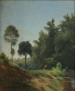
Sold2021AARON DRAPER SHATTUCK AMERICAN 1832-1928Green River Westfield, MA, oil on canvas, 12 x 9 1/2 in (30.9 x 24.1 cm), framed 19 x 17 in (48.3 x 43.2 cm), PROVENANCE: Descended through the artist's family to private collection in Granby, CT. ThiSee Sold Price
Sold2018RARE HALF-PLATE DAGUERREOTYPE OF EAST WINDSOR, CT.Cased Daguerreotype Photo of the Colonial Sexton Mansion on Warehouse Point in East Windsor, now 99 Main St., built circa 1810, this image taken circa 1845, from the vantage of the road, surrounded bySee Sold Price
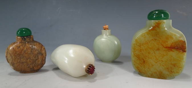
Sold20154 Chinese jade/hardstone snuff bottles, 20th C.4 Chinese jade/hardstone snuff bottles, 20th C. In white, celadon and brown coloring. {WT} (MFER6504/4) Property from a Private Collection in the European taste: South Kent, CT & East 87th Street, NYCSee Sold Price
Sold2022Butting Goats Bell RingerMade by Gong Bell Mfg. Company East Hampton, Ct. -1895 - 8 3/4" Long. This esoteric animal-themed bell toy is one of Gong Bell's most difficult to find. Even advanced sophisticated toy collectors maySee Sold Price
Sold2023Large Lot - Currency and Related MaterialsCurrency and related materials. Three uncut sheets of checks consisting of: The Bank of New England - sheet of four denominations 3, 5,10, 20 dollars. East Haddam, CT. ; uncut sheet of three denominatSee Sold Price
Sold2020Black Boy Riding Duck Bell ToyGong Bell Mfg. Co. East Hampton, CT - 1895 - 7" L A very scarce and colorful bell toy with a fairy tale theme of a young black boy riding a duck. The boy and duck move side to side causing the bell toSee Sold Price
Sold2015Seven snuff and perfume bottles, 20th C.Seven snuff and perfume bottles, 20th C. Includes blue overlay glass, wood and colored glass. {WT} (MFER6506/7) Property from a Private Collection in the European taste: South Kent, CT & East 87th StrSee Sold Price
Sold2024Henry P. SMITH Antique Oil Painting on Canvas. River landscape. (American 1854-1907) Labeled: "The RHenry P. SMITH Antique Oil Painting on Canvas. River landscape. (American 1854-1907) Labeled: "The Riverside at East Lyme Ct." Signed lower right "Henry P. Smith". Housed in original frame Dimensions:See Sold Price
Sold2016Ortelius map of East Indies 1570Heading: Author: Ortelius, Abraham Title: Indiae Orientalis Insularumque Adjacientium Typus Place Published: [Antwerp] Publisher: Date Published: 1570- Description: Copper-engraSee Sold Price
Sold2023Antique 19th C. Map of East Los Angeles CountyAntique 19th Century panoramic map of East Los Angeles County, California, depicting a bird's-eye view from Los Angeles River looking towards the Sierra Madre Mountains. Printed by H.S. Crocker & Co.,See Sold Price
Sold2020Engraved Map of the East Coast of AmericaJacques-Nicolas Bellin (1703-1772), "Carte Reduite des Costes Orientales de L'Amerique Septentrionale," Paris, 1757. Hand colored engraved map of the northeast coast of North America, showing what isSee Sold Price
Sold2023Visscher Map of South East AsiaVISSCHER, Nicolas (1618-1679). Indiae Orientalis, nec non Insularum Adiacentium Nova Descriptio. Engraved map with great original hand color in full. Amsterdam, c. 1698. 20 1/2" x 24 1/8" sheet. ThisSee Sold Price
Sold2022Middle East.- Saudi Arabia.- Saudi Aramco (publisher) Collection of maps and ephemera from compiledMiddle East.- Saudi Arabia.- Saudi Aramco (publisher) and others. Collection of maps and ephemera compiled by a British Engineer working in the Middle East, including 5 laminated maps of Saudi Arabia,See Sold Price
Sold2017STEAM BOAT PAPER/LETTERHEAD, TRAVEL CHARTS/MAPSBOX LOT ASSORTED STEAM BOAT PAPER/LETTERHEAD, TRAVEL CHARTS/MAPS, BROADSIDE WALTER BRETT, 1869See Sold Price
Sold2023Middle East.- Aramco.- Duce (James Terry) Middle East Oil Developments, Arabian American Oil Co.,Middle East.- Aramco.- Duce (James Terry) Middle East Oil Developments, full-page maps and illustrations, one with acetate overlay, occasional underlining, original paper wrappers, plastic ring binderSee Sold Price
Sold2020Original Map, Nantucket Drawn by Rev F.C. Ewer, 1869Original Historical Map of Nantucket Surveyed and Drawn by Reverend F.C. Ewer D.D., 1869, (Ferdinand Cartwright 1826-1883) mounted on canvas, unframed. 12 ¾ in. x 20 in.See Sold Price
Sold2022Cadastral map of land in Portola district SF 1869Heading: -1869 Author: Title: Plan of the Haley Purchase, west of and adjoining the Hudson Tract. To be sold by Maurice Dore & Co. April 27th, 1869. Title U.S. Patent, and Bernal Rancho Place PublishSee Sold Price
3 days LeftTreasure of Gems & JewelryNatural Swiss Blue Topaz 18.69 Ct. Clean Pear Shape 22 x 12.8 Mm. Gemstone From Brazil$1(1 bid)
9 hrs LeftThe Bidder AuctionsOttoman Empire. 3 large hand painted maps of the middle east on cloth, Tax stamps of Ottoman Empire,$100
Jun 08Leon GalleryAbraham Ortelius (1527 - 1598) - Indiae Orientalis (Philippines/China/ India/ Southeast Asia)₱200,000
Jun 07Freeman's | Hindman[MAP]. ORTELIUS, Abraham. Peregrinationis Divi Pauli Typus Corographicus. 1592.$150(1 bid)
Jun 15Bazaar of PersiaAIG certificate 13 pcs Daimonds lot - 1.56 ct Fancy Mix Yellow - Brown - Orange$500
Jun 08Early American History Auctions1836 Hand-Colored Map, Country Twenty Five Miles Round The City Of New-York Published by D.S. Stone$260
Jun 08Leon GalleryVincenzo Maria Coronelli (1650-1718) - Uniform set of two large globe gores of the Far East₱400,000
Jun 15Bazaar of PersiaLot China - Empire - 1930 Junk Ship Surcharged In overprint Red - 1Ct On 3Ct 1Ct On 4 Ct$100
Jun 23Schilb Antiquarian Rare Books1877 Geology Geography Surveys 1ed Nevada Wyoming Utah George Wheeler US West 2v$1
1 day LeftNY Elizabeth FIRST US EDITION OF 1869 MALAY ARCHIPELAGO BY A.WALLACE, ANTIQUE ILLUSTRATED WITH MAPS$50(1 bid)


![Ortelius map of East Indies 1570: Heading: Author: Ortelius, Abraham Title: Indiae Orientalis Insularumque Adjacientium Typus Place Published: [Antwerp] Publisher: Date Published: 1570- Description: Copper-engra](https://p1.liveauctioneers.com/642/86438/44449716_1_x.jpg?height=310&quality=70&version=1458591928)


![[MAP]. ORTELIUS, Abraham. Turcici Imperii Descriptio.1592. (1 of 2)](https://p1.liveauctioneers.com/197/329395/177650538_1_x.jpg?height=282&quality=70&version=1715364962)


![[MAP]. ORTELIUS, Abraham. Peregrinationis Divi Pauli Typus Corographicus. 1592. (1 of 2)](https://p1.liveauctioneers.com/197/329395/177650535_1_x.jpg?height=282&quality=70&version=1715364962)


