Sold2019Isles Philippines, Célèbes & Moluques'. East Indies.TITLE/CONTENT OF MAP: 'Carte des Isle Philippines, Célèbes, & Moluques [Map of the Philippines, Sulawesi, and the Maluku Islands]' Philippines, Borneo, Sulawesi, Moluccas / Maluku & Lesser Sunda IslSee Sold Price
Sold2023Antique copper engraved map - Moluccas IslandsBeautiful and scarce copper engraved map of the Moluccas Islands from a German edition (1685 or 1719) of Allain Manesson Mallet's monumental Description de l' Universe. This work was first published iSee Sold Price
Sold2018Bellin: Antique Map of Maluku Islands, 1740Title/Content of Map: Maluku Islands of Eastern Indonesia Date Printed: 1740-70's Cartographer: J.N. Bellin & J.F. La Harpe Material/Medium: Paper Size: 6" x 9 3/4" Copperplate engraved. Published inSee Sold Price
Sold2021Stanford (Pub) 1894 Lot of 9 Maps of Asia East IndiesIncl Celebes, Sumatra, Borneo, Java, Philippines, Stations of Government Officials in the East Indies, Volcanic System of Malaysia, Moluccas, and Sunda Islands. Lithograph Maps Published 1894 by EdwarSee Sold Price
Sold2017Bellin: Antique Map of Maluku Islands, Indonesia, 1757Title/Content of Map: 'Carte Particuliere des Isles Moluques. ' Maluku Islands - Halmahera - Ternate - Pulau Tidore - Makian Island - Bacan - Palamea Date Printed: 1757 Image Size: Approx 23.5 x 16.5cSee Sold Price
Sold2019Bellin: Spice Islands (Moluccas), IndonesiaMap Title: Carte Particuliere des Isles Moluques Cartographer: Bellin Place / Date: Paris / 1752/1760 Size: 6" x 8 1/2" Condition: b&w; light overall age toning; map mounted on contemporary paper to fSee Sold Price
Sold2016Spice Islands Indonesia/ Moluccas, 1636Map Title: Insularum Moluccarum Nova descriptio (The Fabled Spice Islands Indonesia/ Moluccas) Published: Hondius, H./ Jansson, J., Amsterdam Date: 1636 Size: 15 x 19 1/2 inches (engraved surface exclSee Sold Price
Sold2023Antique 17th C Map of Canary Islands Pierre DuvalAntique 17th C Map of Canary Islands Pierre Duval. Original proof engraved in 1653 by cartographer Pierre Duval (French, 1618 - 1683). Colored boundaries of the time. Engraving margins measure 13.5 inSee Sold Price
Sold2020Pierre Duval Nova Mexico Map ca. 1660 CaliforniaPierre Duval (1618-1683), "Nova Mexico," Nuremberg, ca. 1660-1680. This rare map depicts California as an island, based on Sanson's depiction, along with the surrounding areas of Mexico and what is noSee Sold Price
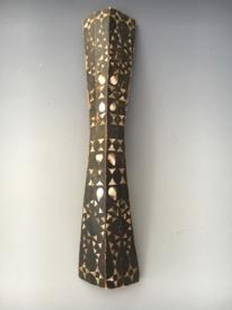
Sold2024Moluccas Islands Ancestor Figure. Carved wood.Moluccas Islands Ancestor Figure. Carved wood. For measures please refer to the pictures taken with a measuring tape. This is a NO RESERVE AUCTION: there are no hidden or confidential reserves, all acSee Sold Price
Sold202120th C. Indonesian Malaku Islands Ancestral Marker**Originally Listed At $1500** Southeast Asia, Indonesia, southeastern Malaku Islands (Moluccas / Spice Islands), ca. early 20th century CE. A massive carved wooden ancestral marker, made of two pieceSee Sold Price
Sold2019African Wedding Dance Shield Ambon Island Maluku IslandAfrican Wedding Dance Shield Ambon Island Maluku Island Chain, Indonesia 19c Wood w/Shell inlay COA Provided 31H x 6W x 6L PICK UP IN NEW HAVEN, CT est value $100-300See Sold Price
Sold2021Boating Maps, Long Island, Long Island north end, eastMaps from 1981 tropic Isle publishers, Inc. by Harry Klein, Long Island, Long Island Northwynn, East Coast harbors. Size, 11” x17”See Sold Price
Sold202417TH C. MERCATOR'S MAP - SMALLER ISLANDS ANGLESEA CHANNELL ISLANDS17TH CENTURY (1636) HAND COLORED MERCATOR'S MAP OF THE SMALLER ISLANDS, ANGLESEY CHANNELL ISLANDS, ISLE OF WIGHT, JARSAY, GARNESAY - FRAME MEASURES APPROX. 21" X 17"See Sold Price
Sold20231938 R Taylor White Pictorial Map of Rhode Island -- Rhode Island "Little Rhody"Title: 1938 R Taylor White Pictorial Map of Rhode Island -- Rhode Island "Little Rhody" Cartographer: Ruth Taylor White Year/Place: 1938, Boston Dimensions: 11.6 x 8.5 in. Description: This is Ruth TaSee Sold Price
Sold2021Boating maps, royal island harbor, egg islands, currentMaps from 1981 tropic Isle publishers, Inc By Harry Kline, Royal island harbor, egg Islands, current island Anchorage. Size 11“ x 17“See Sold Price
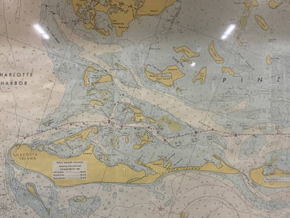
Sold2024Vintage Framed Pine Island & Lacoste Island MapVintage full color paper map, marked on top Pine island, Charlotte harbor and Lacosta island. Showing waterways and directions. Framed in a wooden frame. Approx 14 x 18 inches window measures 11.5 x 1See Sold Price
Sold20221970s Nautical Navigations Maps Long Island Sound, Block Island & More 47"x35"1970s Nautical Navigations Maps Long Island Sound, Block Island & More 47"x35"See Sold Price
Sold20171851 Tallis Map of Islands in the Atlantic1851 Tallis Map of Islands in the Atlantic J. Tallis 1851 London 14 x 10 in. plus matting Beautiful steel engraved map consisting of four maps of the islands: the island groups of Cape Verde, CanariesSee Sold Price
Sold2017Baldwin / Kitchin: Antique Maps Windward Islands, 1782Title/Content of Map: 1782 Baldwin / Kitchin Maps of the Windward Islands -- Island of St. Lucia [on sheet with] Island of St. Vincent [on sheet with] Island of Barbados [on sheet with] Chart of PartSee Sold Price
Sold2019Vintage Map of Fiji Islands and Samoa IslandsVintage Map of Fiji Islands and Samoa IslandsSee Sold Price
Sold20231902 Cram Map of Long Island -- Map of Long Island New YorkTitle: 1902 Cram Map of Long Island -- Map of Long Island New York Cartographer: G Cram Year/Place: 1902, Chicago Dimensions: 9.8 X 12.4 in. Description: This is an attractive map of Long island withSee Sold Price
Sold2022Submarine Map of Long Island Sound, Block IslandSubmarine Map of Long Island Sound, Block Island, together with a book on United States Submarines by Robert Hatfield Barnes with had inscribed dedication to the Officers and the Men of the United StaSee Sold Price
Sold2021Redstone Studios Oil on Canvas, "Map of NantucketRedstone Studios Oil on Canvas, "Map of Nantucket Island", including Muskeget Island, Tuckernuck Island and various points of interest including Brant Point Lighthouse, Sankaty Lighthouse, Great PointSee Sold Price
Jun 08Leon GalleryRobert Dudley (1573 - 1649) - Carta particolare del'Isola Mindano parte Australe con Celebes e₱500,000
Featured5 days LeftJasper521750 Bowen Map of Bermuda and St. Kitts -- A New & Accurate Map of Bermudas or Sommer's Islands...$600
1 day LeftTrillium Antique Prints & Rare BooksSanson - Map of the Sunda Islands, Sumatra, Java, & Borneo$75
5 days LeftJasper521720 Chatelain Map of Scotland -- Nouvelle Carte d'Ecosse, ou l'on Fait Observer l'Etat de la Nobles$240
1 day LeftTrillium Antique Prints & Rare BooksSanson - Map of the Philippines and Ladrones Islands$75


![Isles Philippines, Célèbes & Moluques'. East Indies.: TITLE/CONTENT OF MAP: 'Carte des Isle Philippines, Célèbes, & Moluques [Map of the Philippines, Sulawesi, and the Maluku Islands]' Philippines, Borneo, Sulawesi, Moluccas / Maluku & Lesser Sunda Isl](https://p1.liveauctioneers.com/5584/139429/70692793_1_x.jpg?height=310&quality=70&version=1554845662)


![Baldwin / Kitchin: Antique Maps Windward Islands, 1782: Title/Content of Map: 1782 Baldwin / Kitchin Maps of the Windward Islands -- Island of St. Lucia [on sheet with] Island of St. Vincent [on sheet with] Island of Barbados [on sheet with] Chart of Part](https://p1.liveauctioneers.com/5584/110608/56777137_1_x.jpg?height=310&quality=70&version=1507840413)


