Sold20201798 Monterey California North America MapTitle: Plan de la Baie de Monterey" - Monterey California North America map Karte Amerika Atlas du Voyage de la Perouse. Published: by G.G. & J. Robinson, Pater-noster Row. Size: Artwork: 10 x 15 1/2See Sold Price
Sold2015Chart of Monterey, CA 1844Heading: (California) Author: Duflot de Mofras, Eugene Title: Plan du Port et de la Baie de Monte-Rey Situes sur la Cote Septle. de la Californie [on sheet with] Baie de la Trinidad Place Published: [See Sold Price
Sold2016Map of New York Bay. North America. 1839.Print of steel engraving titled „Plan de la baie de New-York“.Drawn by unknown.Engraved by Blondeau.From „Etats-Unis D‘Amerique by M. Roux de Rochelle. Published by Firmin didot freres. Paris.See Sold Price
Sold2017Bellin: Antique Map Plan of Veracruz, Mexico, 1754Title/Content of Map: Plan de la Rade et Ville de la Vera-cruz. Situee par 19. deg. 10 min. de Lat. Sep. et 100 d. 15 m. a l'Occid de Paris Date Printed: 1754 Cartographer: Bellin, Jacques Nicolas SizSee Sold Price
Sold2020Plan de la Baie et de la Ville de PortobeloTITLE/CONTENT OF MAP: 'Plan de la Baie et de la Ville de Portobelo [Plan of the bay and the city of Portobelo]' The top image on the right hand side shows the entire map. To view a close up of the mapSee Sold Price
Sold2022Marc Chagall (1887-1985) Russian French (four)LA BAIE DE ANGES (M.286; H.286), 1960; LA TOUR EIFFEL VERTE (M.201; H.201), 1957; two color lithograph bookplates, the first sheet 12 ½ x 9 ½”, second sight 7 ¼ x 8 ¾See Sold Price
Sold2021Bellin, Jacques-Nicolas - Plan du port et ville deBellin, Jacques-Nicolas (1703-1772) Plan du port et ville de Louisbourg dans l'Isle royale (1744) Description: P.N.B. Ing. de la M. 1744. Extract from the Petit atlas maritime published in Paris in 17See Sold Price
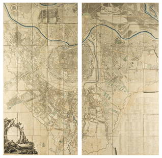
Sold2023Esnauts (Jacques) Nouveau Plan Routier de la Ville et Faubourgs de Paris Avec ses Principaux EdificeEsnauts (Jacques) and Michel Rapilly. Nouveau Plan Routier de la Ville et Faubourgs de Paris Avec ses Principaux Edifices Par M. Pichon, large wall map of Paris, the border decorated with 28 vignettesSee Sold Price
Sold2020Voyages.- La Perouse (Jean-Francois de Galaup) TheVoyages.- La Pérouse (Jean-Francois de Galaup) The Voyage of La Pérouse Round the World in the years 1785, 1786, 1787, and 1788, edited by M.L.A.Milet Mureau, 2 vol., engraved portrait frontSee Sold Price
Sold2017La Perouse: Map of Port of San Diego, 1797Map: Plan du Port de St. Diego en Californie/Plan du Port et du Department de St. Blas Cartographer: La Perouse Place & Date: Paris / 1797 Size: 19 1/2" x 13 1/4" Plate 35 from the Atlas volume of LaSee Sold Price
Sold2022Jean-Michel Folon "Saint-Michel" Mixed MediaJean-Michel Folon (Belgian, 1934-2005) Post-Modern mixed media collage with Biscuiterie de la Baie de Mont St Michel packaging mounted on paper with geometric watercolor painting, signed to lower righSee Sold Price
Sold2017Dela Haye: Plan de la Baye de l'Acul (Haiti), 1787Map: Plan de la Baye de l'Acul; Baye de Dame-Marie; Le Port François; Plan du Môle St. Nicolas; Baye des Irois Cartographer: Dela Haye / Dépôt de la Marine Place & Date: Paris / 1787 Size: 17 1/2"See Sold Price
Sold2023Freminville Original Watercolors, Poissons de L'Isle de La Perouse ou VanikoroFREMINVILLE, Christophe Paulin de la Poix de (French, 1787-1848). Poissons de L'Isle de La Perouse ou Vanikoro... 1. Le Caranx a bandes Quay (Mantenguesey) / 2. La Cluppe pectorale Quoy Coesio tacheteSee Sold Price
Sold2017J.-N. Bellin, "Plan de la Nouvelle Orleans""Plan de la Nouvelle Orleans", by Jacques Nicolas Bellin (French, 1703-1772), hand-colored copper engraved map on laid paper, from Abbe Antoine Francois Prevost'sL'Histoire Generale des Voyages..., voSee Sold Price
Sold2017Octavo Edition of La Perouse's VoyageRelation du voyage à la recherche de La Pérouse fait par ordre de l'Assemblée Constituante, pendant les années 1791, 1792, et pendant la Iere. et la 2e. année de la République Françoise. LA PERSee Sold Price
Sold2016Pacific Voyages.- La Perouse (Jean Francois Galaup de)Pacific Voyages.- La Perouse (Jean Francois Galaup de) Voyage de La Perouse autour du Monde, 5 vol. (including Atlas), mixed set, 4 text vol. first edition with engraved portrait frontispiece to vol.1See Sold Price
Sold2018Austria.- Grimm (Maximilian von) Grundriss der Kl: Kl:Austria.- Grimm (Maximilian von) Grundriss der Kl: Kl: Haupt und Residenzstadt Wien mit ihren Vorstadten nach den Neuen Hausnumern 1797 / Plan de la Ville de Vienne et de ses Fouxbourgs avec le DenombSee Sold Price
Sold2021Jacques Nicolas Bellin MapsJacques Nicolas Bellin , "Plan de La Nouvelle Orleans" and "Carte des Embouchures du Mississipi", two hand-colored engraved maps, from Le Petit Atlas Maritime, 1764, 7 1/2 in. x 11 in., framed . ProveSee Sold Price
Sold202119th Century Map of MemphisPLAN DE LA VILLE DE MEMPHIS (ETATS-UNIS) 40,000 HABITANTS pen and ink with watercolor hand drawn drainage system map, circa 1870. Depicts a grid street plan of the city of Memphis with labeled streetSee Sold Price
Sold2016Large plan of Paris 1814Heading: Author: Bonnisel, J. Title: Plan de la Ville et Faubourgs de Paris avec ses Monuments… Place Published: Paris Publisher: Date Published: 1814 Description: EngravedSee Sold Price
Sold2022SARTINE, ANTOINE DE Carte d'une partie des côtes de la Floride et de la Louisiane, contenant leSARTINE, ANTOINE DE Carte d'une partie des côtes de la Floride et de la Louisiane, contenant le cours du Mississipi, depuis ses... [Paris: Dépôt des Cartes et Plans de la Marine], 1778.See Sold Price
Sold20171785 Historic Book: Historie de Kentucke, + MAPColonial America 1785 “Historie de Kentucke, Nouvelle Colonie a l’Ouest de la Virginie” & Map by M. John Filson by M. Parraud, Paris Buisson 1785-Dated, Historic Book titled, “Historie de KentSee Sold Price
Sold2021Folk Art Montreal Historic Joe Beef SignVintage Quebec Folk Art Original Location Carved Montreal Historic Joe Beef Sign, From De La Commune Street. Signed M. Gauthier 78. Measures 29 X 12.5 Inches.See Sold Price
Sold2020Main plans, ports, and harbors of the MediterraneanHeading: Author: Roux, Joseph Title: Receuil sic des principaux plans, des ports, et rades de la Mer Mediterranée Place Published: Marseille Publisher:Joseph Roux et Fils Date Published: 176See Sold Price
2 days LeftFichter KunsthandelF. PIRANESI (*1758) after PIRANESI (*1720), Figurine capital from Pompeii, 1806, Etching€500
5 days LeftForum AuctionsSalvador Dalí (1904-1989) Le Cerf se voyant dans l'eau, from Le Bestiaire de la Fontaine Dalinisé£180
5 days LeftForum AuctionsSalvador Dalí (1904-1989) Le Bestiaire de la Fontaine Dalinisé (Field 74-1; M&L 653-664c)£4,500
May 21Capitoliumart s.r.l.SANDRA MARCONATO Modular compositionTapestry composed of three elements with diagonal polychrome ban€5,000
5 days LeftForum AuctionsSalvador Dalí (1904-1989) El sueño de la razón produce monstruos, from Les Caprices de Goya de£400
5 days LeftForum AuctionsSalvador Dalí (1904-1989) Immortalité stéréoscopique et stéréochimique de la monarchie, from£600
5 days LeftForum AuctionsSalvador Dalí (1904-1989) Sator, from Faust (La Nuit de Walpurgis) (Field 69-1D; M&L 304b)£450


![Chart of Monterey, CA 1844: Heading: (California) Author: Duflot de Mofras, Eugene Title: Plan du Port et de la Baie de Monte-Rey Situes sur la Cote Septle. de la Californie [on sheet with] Baie de la Trinidad Place Published: [](https://p1.liveauctioneers.com/642/76512/40002160_1_x.jpg?height=310&quality=70&version=1439854545)


![Plan de la Baie et de la Ville de Portobelo: TITLE/CONTENT OF MAP: 'Plan de la Baie et de la Ville de Portobelo [Plan of the bay and the city of Portobelo]' The top image on the right hand side shows the entire map. To view a close up of the map](https://p1.liveauctioneers.com/5584/182355/91727023_1_x.jpg?height=310&quality=70&version=1603285541)


![SARTINE, ANTOINE DE Carte d'une partie des côtes de la Floride et de la Louisiane, contenant le: SARTINE, ANTOINE DE Carte d'une partie des côtes de la Floride et de la Louisiane, contenant le cours du Mississipi, depuis ses... [Paris: Dépôt des Cartes et Plans de la Marine], 1778.](https://p1.liveauctioneers.com/292/250642/130213716_1_x.jpg?height=310&quality=70&version=1654271664)


![[ILLUSTRATED BOOKS]. Group of 4 Illustrated Titles. [V.p., ... (1 of 1)](https://p1.liveauctioneers.com/928/328184/176813601_1_x.jpg?height=282&quality=70&version=1714496988)


