Sold2021Map of Texan, Indian Terr. & N. Mex., 1868Terrific post-Civil War school atlas map of the region. Map drawn by Oliver J. Stuart. Numerous Indian tribes, counties, towns, forts, rivers, and other details. Inset of Galveston area. Full originalSee Sold Price
Sold20201892 Cowles Civil War Map of Battles in SoutheasternTitle: 1892 Cowles Civil War Map of Battles in Southeastern Virginia -- Military Department of Southeastern Virginia and Fort Monroe, 1861 [Plate XVI] Date: 1892, Washington Cartographer: C Cowles (coSee Sold Price
Sold20201892 Cowles Civil War Map of Battles in SoutheasternTitle: 1892 Cowles Civil War Map of Battles in Southeastern Virginia -- Military Department of Southeastern Virginia and Fort Monroe Showing the Approaches to Richmond and Petersburg, 1861 [Plate XVIISee Sold Price
Sold2023Four Plans to Confederate Forts at Mobile, AlabamaPublication Date: 1892 Title: Four Plans to Confederate Forts at Mobile, Alabama Cartographer: MCALESTER,MILES DANIEL Publisher: WAR DEPARTMENT Height: 16.5 Width: 16.50 Plate CVIII from the Atlas toSee Sold Price
Sold2019Civil War Atlas, "General Topographic Map, Ga.,Civil War Atlas, "General Topographic Map, Ga., Florida," Plate 145, H. - 18 1/2 in., W. - 29 1/2 in.See Sold Price
Sold2019Civil War Atlas, "General Topographic Map, Ga.,Civil War Atlas, "General Topographic Map, Ga., Carolina," Plate 143, H. - 18 1/2 in., W. - 29 in.See Sold Price
Sold2019Two Copies of Civil War Atlas, " General TopographicTwo Copies of Civil War Atlas, " General Topographic Map, La., Miss.," Plate 155, H. - 18 1/2 in., W. - 29 1/2 in. (2 Pcs.)See Sold Price
Sold2019Two Copies of Civil War Atlas, "General TopographicTwo Copies of Civil War Atlas, "General Topographic Map, South La., Miss.," Plate 156, H. - 18 1/2 in., W. - 30 in. (2 Pcs.)See Sold Price
Sold2023Fort Henry and Fort Donaldson (Civil War)Fort Henry and Fort Donaldson The Battle of Fort Henry was fought on February 6, 1862, in Donelson, Stewart County, Tennessee, during the American Civil War. It was the first imSee Sold Price
Sold2021Fort Henry and Fort Donaldson (Civil War)Fort Henry and Fort Donaldson The Battle of Fort Henry was fought on February 6, 1862, in Donelson, Stewart County, Tennessee, during the American Civil War. It was the first imSee Sold Price
Sold2021FROM FORT HENRY TO CORINTH : CAMPAIGNS OF THE CIVIL WARTitle: FROM FORT HENRY TO CORINTH : CAMPAIGNS OF THE CIVIL WAR Author: Brig General M.F.Force Publishing Info: Scribners Edition: First Edition Publishing Date: 1881 Additional Information: Book coverSee Sold Price
Sold20182 Colton Civil War Maps, Military Stations & Forts, 3Two (2) Colton Civil War maps, 3 items total. 1st item: J.H. Colton, Civil War era map of the United States showing Military Stations and Forts, prepared for The Rebellion Record, New York: G.P. PutnaSee Sold Price
Sold20192 Prints and 1 MapIncludes Fort Necessity map and Gettysburg, Pickett’s Charge Print. MEASUREMENTS: 9” high to 19-1/2” high. 11” wide to 16” wide.See Sold Price
Sold2017Johnson's Illustrated Family Atlas, Civil War EditionMap: Johnson's New Illustrated (Steel Plate) Family Atlas, Civil War Edition ISBN/ASIN: B00EMLKE5E Author: A. J. Johnson Publisher: Johnson and Ward Release Date: 1864 Size: 14.5 inches wide x 18.5 inSee Sold Price
Sold20211961 Fort Sumter Civil War Centennial Plate Block1961 Fort Sumter Civil War Centennial Plate Block Vintage Unused United States Postage StampsSee Sold Price
Sold2016George Cram: Nova Scotia Map Plate 2, 1891Map: Nova Scotia Plate 2 Maker: George Cram Date: 1891 Size: 21.75 x 13.5 inches For "The Home Knowledge Atlas" George F. Cram (1842-1928) served in the U.S. Army during the American Civil War. AfterSee Sold Price
Sold20191961 Civil War Centennial Fort Sumter Unused Plate1961 Civil War Centennial Fort Sumter Unused Plate Block StampsSee Sold Price
Sold2019Colton's Civil War map of the United States 1862Heading: (Maps) Author: Colton, J.H. Title: Colton's United States Showing the Military Stations, Forts &c. Place Published: New York Publisher: Date Published: 1862 Description:See Sold Price
Sold2015Battle Maps from Atlas of the Union & ConfederateLithographed by Julius Bien & Co., N.Y., under the direction of Daniel S. Lamont, Government printing office, Washington, D.C., 1893, including Plates LXXXI, LXXXII, LXXXIII, LXXXIV & LXXXV. All are 1See Sold Price
Sold2015Battle Maps from Atlas of the Union & ConfederateLithographed by Julius Bien & Co., N.Y., under the direction of Daniel S. Lamont, Government printing office, Washington, D.C., 1893, including Plates, CXVI, CXVII, CXVIII, CXIX, CXX. All are 18.5 x 2See Sold Price
Sold2015Battle Maps from Atlas of the Union & ConfederateLithographed by Julius Bien & Co., N.Y., under the direction of Daniel S. Lamont, Government printing office, Washington, D.C., 1893, including Plates, CXXVI, CXXVII, CXXVIII, CXXIX, CXXX. All are 18.See Sold Price
Sold2015Battle Maps from Atlas of the Union & ConfederateLithographed by Julius Bien & Co., N.Y., under the direction of Daniel S. Lamont, Government printing office, Washington, D.C., 1893, including Plates, CXXI, CXXII, CXXIII, CXXIV, CXXV. All are 18.5 xSee Sold Price
Sold2022Fine example of Johnson & Ward map of New York, 1863Beautiful map of New York state from Johnson and Ward’s New Illustrated Steel Plate Family Atlas. This scarce map gives a fascinating look at the state during the Civil War. Excellent originalSee Sold Price
Sold2020Vintage 1961 Fort Sumter Civil War Centennial UnusedVintage 1961 Fort Sumter Civil War Centennial Unused Plate Block StampsSee Sold Price
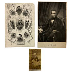
Jun 22Lakeshore Event CenterEphemera, Civil War Generals, Abraham Lincoln, Ulysses Grant, Lot of 3$30(1 bid)
Jun 23Schilb Antiquarian Rare Books1918 Robert E Lee Civil WAR Confederate General CSA Battles MAPS Illustrated$9(3 bids)
Jun 23Schilb Antiquarian Rare Books1890 1ed Confederate Memoirs of Joseph Johnston & Jefferson Davis Civil War CSA$44(2 bids)
4 days LeftHolabird Western Americana CollectionsJefferson Davis Confederate Stamp Sheet, Scott 11 [179366]$750
5 days LeftEarly American History Auctions1863 JOHN ARCHIBALD CAMPBELL ALS Re: a Friends Prisoner Exchange Confederate Asst. Secretary of War$450
5 days LeftEarly American History AuctionsAbraham Lincoln Gettysburg Address on Muslin Cotton Fabric measuring 21.5 x 15.5$100
5 days LeftEarly American History Auctions1905 Civil War General OLIVER OTIS HOWARD Typed Letter Signed as President of the Lincoln Memorial$300
3 days LeftWeatherham Estate TreasuresAbraham Lincoln Bronze Bust Sculpture On Marble Base - Signed Original - 10lbs$400
4 days LeftSimpson Galleries, LLC.JULIUS BIEN (1826-1909) AN AMERICAN CIVIL WAR RECONNAISSANCE MAP, "Map of Texas and Part of New$100
21 hrs LeftJasper521893 Civil War Map of Knoxville Area -- Topographical Map of the Approaches and Defences of$70
21 hrs LeftJasper521893 Civil War Map of Yorktown -- Secession Works at Yorktown [with] The Position of Yorktown with$55
Jun 23Schilb Antiquarian Rare Books1863 1ed Civil War Official Confederate Battle Reports CSA Manassas Charleston$395(6 bids)
21 hrs LeftJasper521854-5 Parke Profile Maps of California, Arizona and New Mexico -- Profiles from San Francisco Bay$55
21 hrs LeftJasper521893 Civil War Map of Siege of Yorktown, Battle of Siloh and Army of Ohio Operations -- Plan of$55
21 hrs LeftJasper521893 Civil War Map Washington, Paducah, KY and Logan's Cross-Roads plus Mill Springs, KY -- Defenses$70
21 hrs LeftJasper521853 Williamson Map of Tejon Pass, California -- Map and Profile of the Tejon Pass from explorations$55
21 hrs LeftJasper521853 Williamson Map of California's Tejon Pass Region -- Map and Profile of the Cañada de las$55
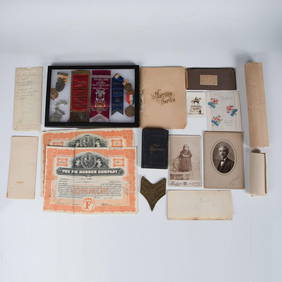
20 hrs LeftJasper521898 US CIVIL WAR GAR PERSONAL WAR SKETCHES HANNIBAL HAMLIN antique FOLIO$220(1 bid)
5 days LeftConnoisseur AuctionsCivil War Battle of Antietam, Abraham Lincoln, General McClellan$20(1 bid)
Jun 23Schilb Antiquarian Rare Books1860 Political Textbook 1ed SLAVERY Abe Lincoln Douglass Civil War Government$7(3 bids)


![1892 Cowles Civil War Map of Battles in Southeastern: Title: 1892 Cowles Civil War Map of Battles in Southeastern Virginia -- Military Department of Southeastern Virginia and Fort Monroe, 1861 [Plate XVI] Date: 1892, Washington Cartographer: C Cowles (co](https://p1.liveauctioneers.com/5584/159675/80583510_1_x.jpg?height=310&quality=70&version=1579644740)


![Jefferson Davis Confederate Stamp Sheet, Scott 11 [179366] (1 of 1)](https://p1.liveauctioneers.com/2699/331499/178846702_1_x.jpg?height=282&quality=70&version=1717095214)


![1893 Civil War Map of Yorktown -- Secession Works at Yorktown [with] The Position of Yorktown with (1 of 1)](https://p1.liveauctioneers.com/5584/331064/178466378_1_x.jpg?height=282&quality=70&version=1716924723)


