Sold2017Bradford: Antique Map of New Hemisphere, 1838Title/Content of Map: New Hemisphere by Bradford Date Printed: 1838/1841 Cartographer: Thomas G. Bradford Material/Medium: Paper Size: 13" x 16 1/2" A General Atlas of the World with a seperate Map ofSee Sold Price
Sold2022Antique Map of the World in Two HemispheresAntique Map of the World in Two Hemispheres - Orbis Vetus, Nicolas Sanson. Overall size: 19 1/2 x 25 1/2 in. Sight size: 15 x 21 in.See Sold Price
Sold2020Antique View and MapColossus of Rhodes. View of one of seven Wonders of Ancient World. Antique engraving. With antique double hemisphere world map, published London, 1822. Sights 10 1/2" x 16 1/2" and 7" x 9".See Sold Price
Sold2023Signed Richard Schultz Knoll Promotional Mini Bocce Ball Set. 2). Walnut Promotional Clock. 3). MidSigned Richard Schultz Knoll Promotional Mini Bocce Ball Set. 2). Walnut Promotional Clock. 3). Mid Century World Map, Airplane Hand Chrome Alarm Clock Dimensions: Height: 5 inches, Width: 4.5 inches,See Sold Price
Sold2024Group of 4 Antique MapsIncludes The World in hemispheres, Minnesota, Nebraska and Asiae Nova Descriptiq, Nebraska map measures 14 1/2 x 19 1/2 inchesSee Sold Price
Sold2017Bradford: Antique Map of Louisiana, 1838Title/Content of Map: Louisiana by Bradford Date Printed: 1838/1841 Cartographer: Thomas G. Bradford Material/Medium: Paper Size: 16 1/2" x 13" Hand colored. A General Atlas of the World with a SeparaSee Sold Price
Sold2017Bradford: Antique Map of Ohio, 1838Title/Content of Map: Ohio by Bradford Date Printed: 1838/1841 Cartographer: Thomas G. Bradford Material/Medium: Paper Size: 13" x 16 1/2" Hand colored. A General Atlas of the World with a Separate MaSee Sold Price
Sold2017Bradford: Antique Map of Maine, 1838Title/Content of Map: Maine by Bradford Date Printed: 1838/1841 Cartographer: Thomas G. Bradford Material/Medium: Paper Size: 13" x 16 1/2" Hand colored. A General Atlas of the World with a Separate MSee Sold Price
Sold2017Bradford: Antique Map of Tennessee, 1838Title/Content of Map: Tennessee by Bradford Date Printed: 1838/1841 Cartographer: Thomas G. Bradford Material/Medium: Paper Size: 13" x 16 1/2" Hand colored. A General Atlas of the World with a SeparaSee Sold Price
Sold2017Bradford: Antique Map of New Hampshire, 1838Title/Content of Map: New Hampshire by Bradford Date Printed: 1838/1841 Cartographer: Thomas G. Bradford Material/Medium: Paper Size: 13" x 16 1/2" Hand colored. A General Atlas of the World with a SeSee Sold Price
Sold2017Bradford: Antique Map of Kentucky, 1838Title/Content of Map: Kentucky by Bradford Date Printed: 1838/1841 Cartographer: Thomas G. Bradford Material/Medium: Paper Size: 16 1/2" x 13" Hand colored. A General Atlas of the World with a SeparatSee Sold Price
Sold2017Bradford: Antique Map of Arkansas, 1838Title/Content of Map: Arkansas by Bradford Date Printed: 1838/1841 Cartographer: Thomas G. Bradford Material/Medium: Paper Size: 13" x 16 1/2" Hand colored. A General Atlas of the World with a SeparatSee Sold Price
Sold2017Bradford: Antique Map of Illinois, 1838Title/Content of Map: Illinois by Bradford Date Printed: 1838/1841 Cartographer: Thomas G. Bradford Material/Medium: Paper Size: 13" x 16 1/2" Hand colored. A General Atlas of the World with a SeparatSee Sold Price
Sold2017Bradford: Antique Map of Alabama, 1838Title/Content of Map: Alabama by Bradford Date Printed: 1838/1841 Cartographer: Thomas G. Bradford Material/Medium: Paper Size: 13" x 16 1/2" Hand colored. A General Atlas of the World with a SeparateSee Sold Price
Sold2017Bradford: Antique Map of Pennsylvania, 1838Title/Content of Map: Pennsylvania by Bradford Date Printed: 1838/1841 Cartographer: Thomas G. Bradford Material/Medium: Paper Size: 16 1/2" x 13" Hand colored. A General Atlas of the World with a SepSee Sold Price
Sold2017Bradford: Antique Map of Upper Canada, 1838Map: Upper Canada Date Printed: 1838/1841 Cartographer: Thomas G. Bradford Material/Medium: Paper Size: 16 1/2" x 13 1/2" Hand colored. A General Atlas of the World, with a seperate map of each of theSee Sold Price
Sold2017Bradford: Antique Map of Indiana, 1838Title/Content of Map: Indiana by Bradford Date Printed: 1838/1841 Cartographer: Thomas G. Bradford Material/Medium: Paper Size: 13" x 16 1/2" Hand colored. A General Atlas of the World with a SeparateSee Sold Price
Sold2017Bradford: Antique Map of Massachusets, 1838Title/Content of Map: Massachusets by Bradford Date Printed: 1838/1841 Cartographer: Thomas G. Bradford Material/Medium: Paper Size: 13" x 16 1/2" Hand colored. A General Atlas of the World with a SepSee Sold Price
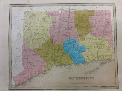
2017Bradford: Antique Map of Conneticut, 1838Title/Content of Map: Conneticut by Bradford Date Printed: 1838/1841 Cartographer: Thomas G. Bradford Material/Medium: Paper Size: 13" x 16 1/2" Hand colored. A General Atlas of the World with a SeparSee Sold Price
Sold2017Bradford: Antique Map of Lower Canada, 1838Title/Content of Map: Lower Canada and New Brunswick Date Printed: 1838/1841 Cartographer: Thomas G. Bradford Material/Medium: Paper Size: 16 1/2" x 13 1/2" Hand colored. A General Atlas of the WorldSee Sold Price
Sold2017Bradford: Antique Map of Rhode Island, 1838Title/Content of Map: Rhode Island by Bradford Date Printed: 1838/1841 Cartographer: Thomas G. Bradford Material/Medium: Paper Size: 13" x 16 1/2" Hand colored. A General Atlas of the World with a SepSee Sold Price
Sold2023Barclay & Milton C1810 Antique Map. World HemispheresCopper Engraved Map Published C1810, London for "Barclay's Universal Dictionary" by James Barclay. Original outline hand colour. Maps Engraved by W. Milton. Paper Size: 17 x 10.5 inch (43 x 27cm) MinoSee Sold Price
Sold2021Barlow 1807 Antique Map. World HemispheresCopper Engraved Map Published 1807 by Brightly & Kinnersley, Bungay, England for "A General View of the World, Geographical, Historical and Philosophical" by The Rev. E. Blomfield. Engraved by Barlow.See Sold Price
Sold2023Brookes & Baker 1797 Antique Map. World HemispheresCopper Engraved Map Published 1797, London for "The General Gazetteer; Or, Compendious Geographical Dictionary" by Richard Brookes. Engraved by B. Baker. Original outline hand colour. Folds as issued.See Sold Price
6 days LeftTrillium Antique Prints & Rare BooksDonovan's The Natural History of British Shells - 5 Volumes in 2 Books with 180 Engravings$400
3 days LeftJasper52After Charles Antoine Coypel, Sancho Panza arriving on Barataria Island (Don Quijote), 1723-1724$140
3 days LeftJasper52Antique engraving. Second Floor of Noah's Ark or Middle Floor of the Arke. Joodse Oudheden from$500
Jun 06World of Antiques, Inc.Antique 19th Century French Gilt Bronze Cave a Liqueur with Enameled Tantalus Decanter Set$5,000
Jun 06World of Antiques, Inc.A Pair of Antique Circa 1900 French Ormolu Dore Gilt Bronze Chenets Andirons Louis XVI style$600
Jun 06World of Antiques, Inc.Antique Set of 6 Meissen Porcelain Green Vine Cups and Saucers in Box$500
4 days LeftNY Elizabeth 1792 OLD INDIA HISTORY ANTIQUE ILLUSTRATED WITH MAPS OF THE EIGHTEENTH CENTURY IN FRENCH$50
Featured2 days LeftJasper52c1720 World showing Dutch East India Co possessions. CA as a island. By J.Malherbe$600