Sold20211760 Thornton Plan of the London Wards of BillingsgateTitle: 1760 Thornton Plan of the London Wards of Billingsgate and Faringdon -- Plan of Billingsgate Ward and Bridgeward Within, Divided into Parishes from a New Survey [on sheet with] Plan of FaringdoSee Sold Price
Sold2017Bowen: Antique Map of East Indies, 1772Map: East Indies Publication Date: 1772 Authors: G. ROBINSON, BOWEN, T. Publisher: G. ROBINSON Size: Miniature – 7.00 H x 11.10 W Inches "by Thos. Bowen geogr. Engraved for Jones's Geographical GramSee Sold Price
Sold20221720 Strype Map of London Ward by Southwark Bridge on Thames -- Queen Hith Ward and VintryTitle: 1720 Strype Map of London Ward by Southwark Bridge on Thames -- Queen Hith Ward and Vintry Ward… Cartographer: J Strype Year / Place: 1720, London Map Dimension (in.): 11.9 X 6.9 in. ThisSee Sold Price
Sold20201720 Strype Ward Map of London around St. PaulTitle/Content of Map: 1720 Strype Ward Map of London around St. Paul's Cathedral -- The Wards Of Farington Within And Baynard's Castle Â… Cartographer: J Strype Year/Place: 1720, London Size: 11.8See Sold Price
Sold20182-pg. Plan of Boston, Mitchell 1872Reserve Reduced! Impressive layout of Boston, hand colored by wards. Highly detailed large format map shows railroad lines, roads, streets, wharfs, bridges, buildings, rivers and other landmarks. ExteSee Sold Price
Sold20181877 NEW YORK History Illustrated MAPS Steamboats US1877 NEW YORK History Illustrated MAPS Steamboats US Bridges 2v Martha Lamb “…three thousand miles from civilization, becomes within three centuries the seat of the arrogant metropolis of the WestSee Sold Price
Sold2019Emmanuel Bowen, Map of GeorgiaEmmanuel Bowen, Map of Georgia, Emmanuel Bowen (British, 1694-1767), "A New Map of Georgia with part of Carolina, Florida and Louisiana", hand-colored lithograph, published in "Complete Collection ofSee Sold Price
Sold2023Emanuel Bowen Map North & South Carolina, Georgia[Emanuel Bowen Map of North & South Carolina and Georgia] , "A New & Accurate Map of the Provinces of North & South Carolina Georgia & c. Drawn from late Surveys and regulated by Astron Observat. By ESee Sold Price
Sold2022Bowen - Map of North and South CarolinaEmanuel Bowen (1694-1767), A New & Accurate Map of the Provinces of North & South Carolina, Georgia, & C., London, circa 1747, in two sheets, engraving on laid paper, with title cartouche in the upperSee Sold Price
Sold2015A FRAMED CHINESE PORCELAIN PAINTINGA Framed Chinese porcelain painting. Hand-painted in famille rose style, of a figurine crossing a bridge within misty mountainous scene. Showing themed calligraphy inscription on top right, followed bSee Sold Price
Sold2021Wedgwood Fairyland Lustre Vase, Imps On A BridgeExceptionally decorated scene of a procession of imps crossing a bridge within a fantasy forested landscape. Polychrome piece in blues, greens purples heightened with gilding throughout. Wedgwood backSee Sold Price
Sold2023A CHINESE RED CORAL 'FIGURES AND LANDSCAPE' SNUFF BOTTLEOf slender ovoid form,the snuff bottle carved around the body with continuous scene of an elderly figure accompanied by a young attendant striding on bridge within a mountain landscape,the reverse witSee Sold Price
Sold20241766 Emanuel Bowen "The Maps And Charts Of The Modern Part Of The Universal History"Printed for T. Osborne, A. Millar, J Rivington, B. Law And Co., T. Longman, C. Ware, and S. BladonSee Sold Price
Sold2023GEORGE CRAM'S AMERICAN ATLAS OF THE UNITED STATESGEORGE CRAM'S AMERICAN ATLAS OF THE UNITED STATESGeorge F. Cram, proprietor of the Western Map Depot, Chicago, IL, 1878. Color maps within.22.1 x 17.6 in. (56.1 x 44.7 cm.)See Sold Price
Sold20177 1/4" Winged Bannerstone. Hancock Co, IN. Ex-Richard7 1/4" Winged Bannerstone. Hancock Co, IN. Ex-Richard Tebbs. Found by Ward Bridges in 1949. Banded Slate. Pictured in Collectors I (CHAPA, p219). NiceSee Sold Price
Sold2016Richard Ward Triple Decker Shelf ClockRichard Ward, Salem Bridge, Connecticut Triple Decker Shelf Clock. Beautiful, rare clock with turned columns, gold gilt and gold gilt claw feet, top columns are tiger maple style, bottom columns are gSee Sold Price
Sold2016FRAMED CHINESE WATERCOLOR FAN PAINTING OF WATERSIDEChinese watercolor fan painting on paper, in graissele drawing depicted waterside panoramic scene showing bridge, trees, rockworks within landscape. Calligraphy of theme inscription followed by artistSee Sold Price
Sold2017Stackhouse: Earliest Independent United States Map 1783Item: Earliest Independent United States Map Maker: Thomas Stackhouse Date: 1783 Measures 16" x 20 1/4" Map fully within boarder. Margin uneven on left side. Strong printing, plate mark easily visibleSee Sold Price
Sold2020Air France. Flying Holidays this Year! Circa 1935.Air France. Flying Holidays this Year! Circa 1935. Offset lithograph travel poster with the airline’s route map printed within the outline of a propeller plane, covering major cities of Europe aSee Sold Price
Sold2019Two Copies of Emanuel Bowen (1693-1767), "A New Map ofTwo Copies of Emanuel Bowen (1693-1767), "A New Map of Georgia, Florida, Louisiana, Carolina," 1748, H.- 15 3/4 in., W.- 20 in.See Sold Price
Sold2023Three Engraved Maps, including Thomas BowenTHREE ENGRAVED MAPS, including THOMAS BOWEN (Welsh, died 1790), "The World, including the late Discoveries, by Capt. Cook and other Circumnavigators," handcolored engraving on laid paper, plate: 11 1/See Sold Price
Sold2020The first obtainable map of Georgia. RARE and IMPORTANTTitle: The first obtainable map of Georgia. RARE and IMPORTANT Date/Period: 1744-1748 Materials: Copperplate engraved Dimensions: 19 x 16 1/4” Map by Emanuel Bowen, published by John Harris in 'NaSee Sold Price
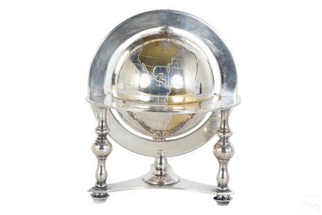
Sold2023Bulgari Sterling Silver & Vermeil Table Globe 805gA Bulgari Italian sterling silver table globe sculpture. Classical style design with spinning world map globe set within a round tri legged ring stand. Map continents finished in gold vermeil, and surSee Sold Price
Sold2020PAIR EARLY 20TH C. CHINESE CHINOISERIE LACQUER CABINETSThe rectangular forms centering two doors with parcel gilt maidens amongst friends amidst a landscape scene with bridges and a pavilion, within a border of stylized scrolling vine interspersed with frSee Sold Price
4 days LeftJasper521720 Strype Ward Map of London's Cheape Ward Between St. Paul's and Bank of England -- Cheape Ward$70
4 days LeftJasper521764 Bowen Map of West India to Iran -- India As Described By All Authors Before The Fifth Century$80
4 days LeftJasper521761 NEW DICTIONARY OF TRADE & COMMERCE R. ROLT antique FOLIO ILLUSTRATED w/MAPS$440
4 days LeftJasper521720 Strype Ward Map of Eastern portions of City of London -- Langborne Ward ? [on sheet with]$80
Featured4 days LeftJasper52Map Showing Distribution of Pinus Palustris (Longleaf Pine) & Pinus Cubensis (Cuban Pine) | Pinus$35
4 days LeftJasper521970s Hawaiian Airlines Pictorial Route Map -- Hawaiian Airlines Map of the Hawaiian Islans$35


![1760 Thornton Plan of the London Wards of Billingsgate: Title: 1760 Thornton Plan of the London Wards of Billingsgate and Faringdon -- Plan of Billingsgate Ward and Bridgeward Within, Divided into Parishes from a New Survey [on sheet with] Plan of Faringdo](https://p1.liveauctioneers.com/5584/208823/106313460_1_x.jpg?height=310&quality=70&version=1625000702)


![Emanuel Bowen Map North & South Carolina, Georgia: [Emanuel Bowen Map of North & South Carolina and Georgia] , "A New & Accurate Map of the Provinces of North & South Carolina Georgia & c. Drawn from late Surveys and regulated by Astron Observat. By E](https://p1.liveauctioneers.com/268/293228/155705053_1_x.jpg?height=310&quality=70&version=1687296979)


![1720 Strype Ward Map of Eastern portions of City of London -- Langborne Ward ? [on sheet with] (1 of 1)](https://p1.liveauctioneers.com/5584/327462/176400787_1_x.jpg?height=282&quality=70&version=1714507756)


