Sold2020BLAEU, WILLEM. Persia Sive Sophorum Regnum.BLAEU, WILLEM. Persia Sive Sophorum Regnum. Hand-colored double-page engraved map of modern-day Afghanistan, Pakistan, Iraq, Iran, and the Persian Gulf region. 15½x21 inches sheet size, top and bSee Sold Price
Sold2023WILLEM BLAEU (1571-1638) MAP of NORMANDIADouble-page engraved map with hand-colored highlights and printed on heavy laid paper 18 3/4 x 23 inches. framed 21 1/2 x 27 inches (overall)See Sold Price
Sold2022(AFRICA.) Two hand-colored double-page engraved eighteenth-century maps of the continent.(AFRICA.) Two hand-colored double-page engraved eighteenth-century maps of the continent. Nuremberg, 1715-1730s - Homann Heirs. Africa Secundum Legitimas Projectionis Stereographicae. 20¾x24¼See Sold Price
Sold2020SPEED, JOHN. Caermarden; and Breknoke.SPEED, JOHN. Caermarden; and Breknoke. Together two hand-colored double-page engraved county maps with town insets. Approximately 16x21 inches each sheet size, ample margins, English text on verso; vaSee Sold Price
Sold2017Two hand colored engraved double page large folio mapsTwo hand colored engraved double page large folio maps including The United States of America and Map of New York and the Adjacent Cities. 16 1/2" x 27" and 17 1/2" x 27" Provenance: Property from CSee Sold Price
Sold2021Blaeu, Willem and Jan22. Blaeu, Willem and Jan.Huntingdonensis Comitatus; Huntington Shire. Double-page hand-coloured engraved map. 15-1/2 x 19-3/4 inches plus margins, in glass-fronted gilt and black wooden frame (worn aSee Sold Price
Sold2022BLAEU, WILLEM Virginiae partis australis et Floridae partis orientalis, interjacentiumq, regionumBLAEU, WILLEM Virginiae partis australis et Floridae partis orientalis, interjacentiumq, regionum Nova Descriptio. Amsterdam: Blaeu, circa 1640. Engraved double-page map with hand-coloring, text on thSee Sold Price
Sold2022(GREAT BRITAIN.) Willem Blaeu. Magnae Britanniae et Hiberniae Tabula.(GREAT BRITAIN.) Willem Blaeu. Magnae Britanniae et Hiberniae Tabula. Double-page engraved map of the British Isles. 20x23¼ inches sheet size, wide margins, blank verso; original hand-color in ouSee Sold Price
Sold2022(FRANCE.) Willem Blaeu. Gallia le Royaume de France.(FRANCE.) Willem Blaeu. Gallia le Royaume de France. Double-page engraved decorative map of France. 18¾x23 inches sheet size, wide margins, Latin text on verso; original hand-color in outline; foSee Sold Price
Sold2022(TITLE-PAGES.) Group of 5 hand-colored engraved seventeenth-century atlas title-pages.(TITLE-PAGES.) Group of 5 hand-colored engraved seventeenth-century atlas title-pages. Vp, vd - Willem and Joan Blaeu. Novus Atlas, das ist Welt-beschreibung... Vierde Theil. 19¾x12¼ inchesSee Sold Price
Sold2021(CELESTIAL.) Ignace Gaston Pardies. [Plate 6 -(CELESTIAL.) Ignace Gaston Pardies. [Plate 6 - Constellations of the Southern Sky]. Hand-colored double-page engraved celestial chart with flanking descriptive columns in Latin and French. 19x28¼See Sold Price
Sold2022(LONDON.) Georg Braun; and Franz Hogenberg. Londinum Feracissimi Angliae Regni Metropolis.(LONDON.) Georg Braun; and Franz Hogenberg. Londinum Feracissimi Angliae Regni Metropolis. Hand-colored double-page engraved plan of London from Civitates Orbis Terrarum. 15½x21 inches sheet sizeSee Sold Price
Sold2022SPEED, JOHN. The Kingdome of Persia.SPEED, JOHN. The Kingdome of Persia. Hand-colored double-page engraved map of modern-day Iran, Pakistan, and Afghanistan with carte-a-figures and city plan border panels. 16½x21¼ inches sheeSee Sold Price
Sold2020(CELESTIAL.) Cellarius, Andreas. Typus Aspectuum,(CELESTIAL.) Cellarius, Andreas. Typus Aspectuum, Oppositionum et Coniuntionum Etz in Planetis. Hand-colored double-page engraved celestial chart with a map of the world on a north-polar projection shSee Sold Price
Sold2018GEORG BRAUN & FRANS HOGENBERG HAND COLORED MAPGEORG BRAUN & FRANS HOGENBERG HAND COLORED DOUBLE-PAGE ENGRAVED MAP, H 13 1/4", W 19", "LUTETIA, VULGARI NOMINE PARIS":DEPICTING 16TH CENTURY PARIS, WITH A DECORATIVE TITLE-CARTOUCHE FEATURING COAT OFSee Sold Price
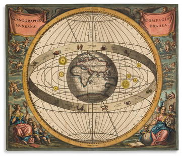
Sold2021(CELESTIAL.) Cellarius, Andreas. Scenographia Compagis(CELESTIAL.) Cellarius, Andreas. Scenographia Compagis Mundanae Brahea. Hand-colored double-page engraved chart of the Tychonic-model solar system with the large central globe positioned to show EarthSee Sold Price
Sold2020SPEED, JOHN. Bohemia.SPEED, JOHN. Bohemia. Hand-colored double-page engraved map of the Czech Republic with carte-a-figures and city plan border panels. 16¼x20½ inches sheet size, margins shaved to the neatline,See Sold Price
Sold2022(ITALY.) Gerard Mercator. Italia.(ITALY.) Gerard Mercator. Italia. Hand-colored double-page engraved map of Italy. 15½x19¼ inches sheet size, ample margins, French text on verso; center fold reinforced on verso, Duisberg, 1See Sold Price
Sold2022(ASIA.) Jean Janvier. l'Asie Divisee en ses Princepaux Etats.(ASIA.) Jean Janvier. l'Asie Divisee en ses Princepaux Etats. Large hand-colored double-page engraved map of the Asian continent, Indonesia, and a remarkably distorted island(?) of New Guinea. 21½See Sold Price
Sold2023Matthaeus Merian. Moscua.[Map-Russia-Moscow] Matthaeus Merian. Moscua. Frankfurt, 1638. Hand-colored double-page engraved plan of Moscow on heavy laid paper. Beautiful bird's eye view of Moscow, with a key on the left hand siSee Sold Price
Sold2020ORTELIUS, ABRAHAM. Hispaniae Novae Sivae Magnae, RecensORTELIUS, ABRAHAM. Hispaniae Novae Sivae Magnae, Recens et Vera Descriptio. Hand-colored double-page engraved map of southwestern Mexico. 17x21½ inches sheet size, wide margins, Latin text on verSee Sold Price
Sold2019ROBERT de VAUGONDY, GILLES Map.ROBERT de VAUGONDY, GILLES: Environs de Paris, Par Le Sr. Robert Geographe Ordinaire Du Roi with Privileged 1753 Hand-colored double-page engraved map of the country surrounding Paris. 20 ¼ x 2See Sold Price
Sold2022BRAUN, GEORG; and HOGENBERG, FRANZ. Civitas Exoniae (Vulgo Excester) Urbs Primaria in ComitatuBRAUN, GEORG; and HOGENBERG, FRANZ. Civitas Exoniae (Vulgo Excester) Urbs Primaria in Comitatu Devoniae. Hand-colored double-page engraved plan of Exeter, Devonshire, from Civitates Orbis Terrarum. 15See Sold Price
Sold201517th C. John Speed, Huntington & Ely MapJohn Speed (British, 1552-1629), "Huntington, both Shire and Shire Town with the ancient citie Ely Described," hand colored, double engraved-page map originally created by noted cartographer, John SpeSee Sold Price
Jun 13Swann Auction Galleries(AMERICAN SOUTHEAST.) Willem Blaeu. Virginiae Partis Australis, et Floridae Partis Orientalis.$375
BonhamsSPEED (JOHN) AND WILLEM BLAEU Pictorial title-pages to Speed's 'Theatre of the Empire of Great B...£10
BonhamsBLAEU (JAN) Delfi Batavorum vernacule Delft, [Amsterdam, 1649 or later]; BLAEU (WILLEM) Novus X...£10
BonhamsETHIOPIA, SOUTH AFRICA AND MADAGASCAR BLAEU (WILLEM) Aethiopia Superior vel Interior, [Amsterdam...£300
Jun 25Freeman's | Hindman[Travel & Exploration] Bowdich, T. Edward: Mission from Cape Coast Castle to Ashantee...$250
Jun 13Swann Auction GalleriesSELLER, JOHN. Two miniature hand-colored engraved maps: New England and New York [and] A New Mapp of$750
Jun 13Swann Auction Galleries(FRANCE and SWITZERLAND.) Johannes Blaeu. Geographiae Blauianae Volumen Septimum, quo Liber XIV, XV$3,000
Jun 13Swann Auction Galleries(CHINA.) Martino Martini; and Joannes Blaeu. Pecheli Sive Peking, Imperii Sinarum Provincia Prima.$1,500
Jun 13Swann Auction Galleries(NEW ENGLAND.) Arnoldus Montanus; or John Ogilby. Novi Belgii Quod Nunc Novi Jorck Vocatur, Novae qe$450
Jun 13Swann Auction Galleries(ASIA.) John Speed. Asia with the Islands Adjoyning Described, the Atire of the People, & Townes of$900
Jun 13Swann Auction Galleries(MEDITERRANEAN ISLANDS.) Abraham Ortelius. Insularum Aliquot Maris Mediterranei Descriptio.$375
Jun 13Swann Auction Galleries(AMERICAN SOUTHEAST.) Gerard Mercator; and Jodocus Hondius. Virginiae Item et Floridae Americae$1,300
3 days LeftWorthington Galleries18th c. Map OBSERVATIONS SUR LES POINTS CARDINAUX. LIGNES, ET CIRCLES DE LA SPHÈ$10
Jun 25Freeman's | Hindman[Color-Plate Books] Jones, Owen, and Jules Goury: Plans, Elevations, Sections, and Details of the$2,000
7 days LeftNye & CompanyJohann Baptista Homann, German 1664-1724, Nova Anglia, Hand-Colored Engraving$250
Jun 13Swann Auction GalleriesRUSCELLI, GIROLAMO. Group of 26 double-page engraved maps from La Geografia di Claudio Tolomeo$1,500
Jun 13Swann Auction Galleries(AMERICAS.) Petrus Bertius; and Pierre Mariette. Carte de l'Amerique.$500
Jun 13Swann Auction Galleries(NEW YORK CITY.) Group of 9 nineteenth-century maps of Manhattan,$600(1 bid)
Jun 13Swann Auction Galleries(THE WHITE HOUSE.) G.W., W.E., and H.V Baist. Two large hand-colored lithographed plans of$375
2 days LeftFreeman's | HindmanHAMILTON, William. -- HANCARVILLE, Pierre-Francois Hugues d'. Collection of Etruscan, Greek and$35,000
2 days LeftFreeman's | Hindman[MAP]. TODESCHI, Pietro. [Nova et Acurata Totius Americae Tabula auct. G.I. Blaeu] America quarta$5,000
Jun 13Swann Auction Galleries(WORLD.) Nicolas de Fer. Mappe-Monde ou Carte Generale de la Terre.$1,500
3 days LeftWorthington GalleriesFirst Edition Hand-colored Map THE NORTH RIDING OF YORKSHIRE by Robert Morden$50


![(CELESTIAL.) Ignace Gaston Pardies. [Plate 6 -: (CELESTIAL.) Ignace Gaston Pardies. [Plate 6 - Constellations of the Southern Sky]. Hand-colored double-page engraved celestial chart with flanking descriptive columns in Latin and French. 19x28¼](https://p1.liveauctioneers.com/199/226915/117191944_1_x.jpg?height=310&quality=70&version=1637249113)


![Matthaeus Merian. Moscua.: [Map-Russia-Moscow] Matthaeus Merian. Moscua. Frankfurt, 1638. Hand-colored double-page engraved plan of Moscow on heavy laid paper. Beautiful bird's eye view of Moscow, with a key on the left hand si](https://p1.liveauctioneers.com/179/305680/163317457_1_x.jpg?height=310&quality=70&version=1697214016)


![AFRICA BLAEU (WILLEM) Africae nova descriptio, [c. 1630 or later] (1 of 2)](https://p1.liveauctioneers.com/1043/316318/178467347_1_x.jpg?height=282&quality=70&version=1717580405)

![BLAEU (JAN) Delfi Batavorum vernacule Delft, [Amsterdam, 1649 or later]; BLAEU (WILLEM) Novus X... (1 of 9)](https://p1.liveauctioneers.com/1043/319451/178359083_1_x.jpg?height=282&quality=70&version=1717515630)

![[Travel & Exploration] Bowdich, T. Edward: Mission from Cape Coast Castle to Ashantee... (1 of 3)](https://p1.liveauctioneers.com/65/332523/179335283_1_x.jpg?height=282&quality=70&version=1717622830)
![SELLER, JOHN. Two miniature hand-colored engraved maps: New England and New York [and] A New Mapp of (1 of 1)](https://p1.liveauctioneers.com/199/332329/179231700_1_x.jpg?height=282&quality=70&version=1717450360)


![[Color-Plate Books] Jones, Owen, and Jules Goury: Plans, Elevations, Sections, and Details of the (1 of 4)](https://p1.liveauctioneers.com/65/332523/179335054_1_x.jpg?height=282&quality=70&version=1717622830)


![[MAP]. TODESCHI, Pietro. [Nova et Acurata Totius Americae Tabula auct. G.I. Blaeu] America quarta (1 of 1)](https://p1.liveauctioneers.com/197/329395/177650542_1_x.jpg?height=282&quality=70&version=1715364962)

