Sold2019Ceylon 1860 Antique Map by Blackie. Sri LankaSteel Engraved Map Published 1860, by Blackie & Son, London for "The Imperial Atlas of Modern Geography" by Walter Graham Blackie. Hand Coloured outline as issued. Paper Size: 14.5 x 10.5 inch (37 x 2See Sold Price
Sold20211886 Map of the Chinese EmpireAuthor: Blackie Title: 1886 Map of the Chinese Empire Materials: Ink on Paper Size/Dimensions: 21"X15" Description: Map of the Chinese Empire dated 1886. Part of the Imperial Atlas of Modern GeographySee Sold Price
Sold20211886 Map of the Philippine IslandsAuthor: Blackie Title: 1886 Map of the Philippine Islands Medium: Ink on Paper Dimensions: 10.5"X15" Map of the Philippine Islands dated 1886. Part of the Imperial Atlas of Modern Geography. This wasSee Sold Price
Sold20211886 Map of AfricaTitle: 1886 Map of Africa Author: Blackie Medium: Ink on Paper Dimensions: 21"X15" Description: Map of Africa dated 1886. Part of the Imperial Atlas of Modern Geography. This was the revised edition uSee Sold Price
20211886 Map of AfricaAuthor: Blackie Title: 1886 Map of Africa Materials: Ink on Paper Size/Dimensions: 21"X15" Description: Map of Africa dated 1886. Part of the Imperial Atlas of Modern Geography. This was the revised eSee Sold Price
Sold20211886 World Hemispherical MapTitle: 1886 World Hemispherical Map Author: Blackie Medium: Ink on Paper Dimensions: 21"X15" Description: World hemispherical map dated 1886. Part of the Imperial Atlas of Modern Geography. This was tSee Sold Price
Sold20211886 Map of Arabia and the Persian GulfAuthor: Blackie Title: 1886 Map of Arabia and the Persian Gulf Medium: Ink on Paper Dimensions: 21"X15" Map of Arabia and the Persian Gulf dated 1886. Part of the Imperial Atlas of Modern Geography. TSee Sold Price
Sold20211886 Map of AsiaAuthor: Blackie Title: 1886 Map of Asia Materials: Ink on Paper Size/Dimensions: 21"X15" Description: Map of Asia dated 1886. Part of the Imperial Atlas of Modern Geography. This was the revised editiSee Sold Price
Sold20211886 Egypt MapAuthor: Blackie Title: 1886 Egypt Map Medium: Ink on Paper Dimensions: 21"X15" Map of the Upper and Lower Egypt dated 1886. Part of the Imperial Atlas of Modern Geography. This was the revised editionSee Sold Price
Sold20211886 Persia and Afghanistan MapAuthor: Blackie Title: 1886 Persia and Afghanistan Map Medium: Ink on Paper Dimensions: 21"X15" Map of Persia and Afghanistan dated 1886. Part of the Imperial Atlas of Modern Geography. This was the rSee Sold Price
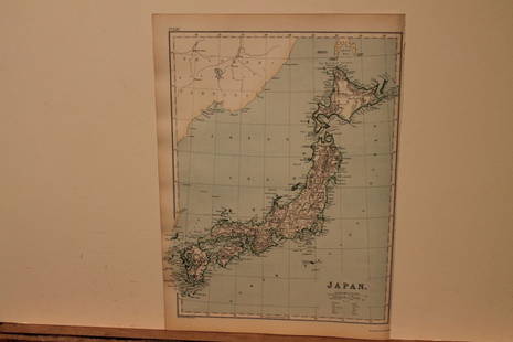
Sold20211886 Map of JapanAuthor: Blackie Title: 1886 Map of Japan Medium: Ink on Paper Dimensions: 10.5"X15" Map of Japan dated 1886. Part of the Imperial Atlas of Modern Geography. This was the revised edition under the supeSee Sold Price
Sold2022Gall & Inglis (publishers) The Edinburgh Imperial AtlasGall & Inglis (publishers) The Edinburgh Imperial Atlas Ancient and Modern, revised and corrected to the Present Time, from the Best Authorities. Edinburgh: Gall & Inglis, c.1860. Folio (52.5 x 33.8cmSee Sold Price
Sold2023WILKES, Charles (1798-1877). Narrative of the United States Exploring Expedition. Philadelphia: LeaWILKES, Charles (1798-1877). Narrative of the United States Exploring Expedition. Philadelphia: Lea & Blanchard, 1845. 6 volumes, comprising 5 text volumes and atlas, imperial 8vo (269 x 173 mm). TextSee Sold Price
Sold2020Territorial Growth of the US 1892Title/ Content of Map:Territorial Growth of the US 1892 Date Printed: 1892 Cartographer: Material/Medium: paper Dimensions: approx. 11x 13.5 inches Additional Information: Illif's Imperial Atlas ReserSee Sold Price
Sold2020Atlas of the county of Sandusky, Ohio by William HoppleThe County of Sandusky Ohio an Imperial Atlas and Art Folio including chronological chart, statistical tables and description of surveys, 1898. The front and back covers are detached and the spine isSee Sold Price
Sold2021Washington DC 1892Title: Washington DC 1892 Date Printed: 1892 Cartographer: Material/Medium: paper Size: approx. 11x 13.5 inches Additional Information: Illif's Imperial Atlas Reserve: $30.00 Shipping: DomestSee Sold Price
Sold20211894 Map of MontanaTitle: 1894 Map of Montana Medium: Ink on Paper Dimensions: 21.5"X14.5" Description: Map of Montana dated 1894. Printed by George Cram for the Imperial Atlas. Published in Chicago. Key lower left. ColSee Sold Price
Sold2024Spain & Portugal 1892Title/Content of Map: Spain & Portugal 1892 Date Printed: 1892 Material/Medium: Paper Size: Approx. 14"x11" Additional Info: Iliff's Imperial Atlas of the World. Publisher: J. A. Stewart & Co, StocktoSee Sold Price
Sold2020Asia 1892Title/Content of Map: Asia 1892 Date Printed: 1892 Material/Medium: Paper Size: approx. 13.5x 21.5 inches Additional Info: Iliff's Imperial Atlas of the World. Publisher: Chicago Reserve: $35.00 ShippSee Sold Price
Sold2024South Africa 1892Title/Content of Map: South Africa 1892 Date Printed: 1892 Material/Medium: Paper Size: Approx. 14"x11" Additional Info: Iliff's Imperial Atlas of the World. Publisher: J. A. Stewart & Co, Stockton, CSee Sold Price
Sold2021Chicago 1896Title: Chicago 1896 Date Printed: 1892 Cartographer: Material/Medium: paper Size: approx. 10.5x 14 inches Additional Information: Illif's Imperial Atlas Reserve: $30.00 Shipping: Domestic: FlSee Sold Price
Sold2021Yellowstone National Park 1891Title/Content of Map: Yellowstone National Park 1891 Date Printed: 1891Material/Medium: Paper Size: 10.5x12.5 inches Iliff's Imperial Atlas, Chicago Reserve: $30.00 Shipping: Domestic: Flat-rate ofSee Sold Price
Sold2021Ireland 1890Title/Content of Map: Ireland 1890 Date Printed: 1890Material/Medium: Paper Size: approx. 11x14 inches Iliff's Imperial Atlas, Chicago Reserve: $30.00 Shipping: Domestic: Flat-rate of $15.00 to anywSee Sold Price
Sold2022Scotland 1890Title/Content of Map: Scotland 1890 Date Printed: 1890 Material/Medium: Paper Size: approx. 11x14 inches Additional Info: Iliff's Imperial Atlas, Chicago Reserve: $30.00 Shipping: Domestic: Flat-rateSee Sold Price
Jun 30Modern JewelryTIFFANY&Co. Ring Atlas Open 3P Diamond 750 K18 WG White Gold US 7 authentic$1,325