Sold2022Coulton Waugh 1930 Map "Old Cape Cod" Hand ColoredHand colored print of "Old Cape Cod" map circa 1930 by Coulton Waugh. Measuring approx. 17" wide x 13" tall. In good condition, see photos. Provenance: Direct acquisition from The Bob and Anne FellerSee Sold Price
Sold20161666 Original Hand Colored Map of Virginiaapprox 21" X 17"...... Pas Caerte van Nieu Nederlandt en de Engelsche Virginies, van Cabo Cod tot Cabo Canrick. (Chart of New Netherland and the English Virginias from Cape Cod to Cape Canrick [i.e. HSee Sold Price
Sold2021CURRIER & IVES - Loss Of The U.S. M. Steam Ship Arctic.Currier & Ives - Loss Of The U.S.M. Steam Ship Arctic, Off Cape Race Wednesday September 27th 1834.Original hand colored lithograph, small folio. Framed and matted in an attractive old wooden frame. NSee Sold Price
Sold2020Coulton Waugh Old Provincetown Hand Colored LithographGreat looking piece. Excellent condition. Listed artist. KNOWN for his work on comic strips. Well done. Measures 12 x 11" from edge of Matte and 17 x 16". Shipping costs include insurance. Shipping: DSee Sold Price
Sold2024Henricus Hondius 1630 "Nova Virginiae Tabula" Hand Colored Map of Virginia and Chesapeake #1Antique, original hand-colored map of Virginia and the Chesapeake Bay originally by Henricus Hondius in 1630 titled "Nova Virginiae Tabula". With French text on reverse final catchword "n'en" and signSee Sold Price
Sold2021(18C.) Antique Hand Colored Map of Old Vienna 1791Antique hand colored etched old map from the famous works published in Vienna in 1791. In three parts, compiled with drawn lines representing extant postal routes at the time. Housed in wooden frame.See Sold Price
Sold2022Original Antique Map -Pommern Provinz - Map of Bornholm Island Baltic SeaAntique outline hand colored map from edition of Meyer’s world atlas, edited by Ludwig Ravenstein, published by Bibliographic Institute in 1872. Technique: Engraving. Place: Leipzig, Germany. SSee Sold Price
Sold2022Original Antique Map - Mecklenburg-Schwerin - Map of Northern GermanyAntique outline hand colored map from edition of Meyer’s world atlas, edited by Ludwig Ravenstein, published by Bibliographic Institute in 1872. Technique: Engraving. Place: Leipzig, Germany. SSee Sold Price
Sold2022Original Antique Map -Bremen Oldenburg - Map of Bremen OldenburgAntique outline hand colored map from edition of Meyer’s world atlas, edited by Ludwig Ravenstein, published by Bibliographic Institute in 1872. Technique: Engraving. Place: Leipzig, Germany. SSee Sold Price
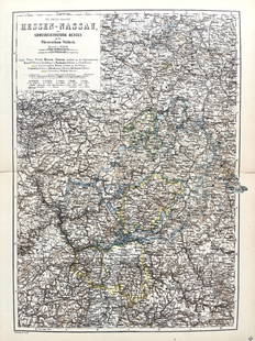
Sold2022Original Antique Map -Hessen Nassau - Map of Furstenthum WaldeckAntique outline hand colored map from edition of Meyer’s world atlas, edited by Ludwig Ravenstein, published by Bibliographic Institute in 1872. Technique: Engraving. Place: Leipzig, Germany. SSee Sold Price
Sold2022Original Antique Map - Konicreich Bohmen - Map of Bohmen - Prague - CarlsbadAntique outline hand colored map from edition of Meyer’s world atlas, edited by Ludwig Ravenstein, published by Bibliographic Institute in 1872. Technique: Engraving. Place: Leipzig, Germany. SSee Sold Price
Sold2024Willem Blaeu 1640 "Nova Virginiae Tabula" Original Hand Colored Map of VirginiaThis loose (unframed) and very scarce original antique 1640 hand-colored "Nova Virginiae Tabula" map of Virginia is in good overall condition, with light-age appropriate wear and apparent repairs-oneSee Sold Price
Sold2024Original Antique Ortelius 1595 Alexandri Magni Macedonis Expedition Map of Alexander's ExpeditionsWell framed as shown. Antique hand-colored map showing Alexander of Macedonia's expeditions by Abraham Ortelius. Framed, matted, and sealed. Unexamined out of frame. Approx. sight size 15 3/8" x 19 3/See Sold Price
Sold2020Jan Jansson Hand Colored Old Map of South AmericaJan Jansson (Johannes Janssonius; Dutch, 1588-1664). Framed antique etching print of South America. Titled AMERICAE PARS MERIDIONALIS. Hand colored. Unknown printing date in two sheets joined in the mSee Sold Price
Sold2017Antique 1839 Old Italy Toscana Monte Cristo Old HandAntique 1839 Old Italy Toscana Monte Cristo Old Hand Colored Map Carta Geometrica Approximately 19 1/4" x 15 1/2".See Sold Price
Sold20201699 D’Eilanden van Capo Verde, de Kust en’t Landt derThis attractive antique hand-colored map features the Cape Verde Islands off the west coast of Africa, and a portion of the coast of western Africa including Muritaniya, Cape Verde, Gambia, and SenegaSee Sold Price
Sold20191848 Mitchell map of VirginiaFully hand-colored original, antique and scarce map that encompasses the future state of West Virginia. “A New Map of Virginia with its Canals, Roads & Distances from Place to Place Along the StageSee Sold Price
Sold2018Hand drawn and colored map of Massachusetts includingHand drawn and colored map of Massachusetts including Cape Cod, Plymouth, Kingston, Duxbury, etc. professionally matted and framed. sight size: 15 1/2" x 19 1/2" Provenance: Property from Credit SuiSee Sold Price
Sold2017Old Map of 1873 "Colton's Dakota"Old Map entitled "Colton's Dakota". Purchased by the consignor as "an original hand colored tinted map from circa 1873". Published by G.W. (and) C.B. Colton & Co. No. 172 William St. New York. At bottSee Sold Price
Sold2021FOUR ANTIQUE HAND COLORED ENGRAVINGS 17TH & 18TH CLot of four antique 17th and 18th century hand colored engravings. Each one framed, includes two Views of Veere, Netherlands, a view of Arnemuiden, as well as an old map of Nova Scotia and New BrunswiSee Sold Price
Sold2023Atlas Maior, vol 4, map 45 - Joan Blaeu, 1667 Antique Copper Engraving Detailed Map. Rhenolandiae etAtlas Maior, vol 4, map 45 - Joan Blaeu, 1667 Antique Copper Engraving Detailed Map. Rhenolandiae et Amstellandiae exactißima Tabula. Original antique copper engraving, hand colored in outline andSee Sold Price
Sold2018Original & Signed "French Dolls" by Cote Etching inArt-Deco "French Dolls" by Cote Hand Colored Etching Under Glass C. 1930 France Original and signed. Etching by Cote Completely original including the wavy antique glass (which has caused reflectionsSee Sold Price
Sold2017Mitchell: Antique Map of Alabama, 1848Clean 1848 Mitchell hand-colored map of Alabama. Highly detailed and collectible map of Alabama with original, rich hand-coloring. A lovely snapshot of mid-19th century history. Nicely centered with gSee Sold Price
Sold2023South America by John Dower. Gran Colombia. La Plata. Brazil 1845 old mapTitle: South America by John Dower. Gran Colombia. La Plata. Brazil 1845 old map Description: South America' by John Dower (1845). Antique map with original hand colouring, 28.0 x 22.5cm, 11 x 8.75 inSee Sold Price
4 days LeftWorthington GalleriesFirst Edition Hand-colored Map THE NORTH RIDING OF YORKSHIRE by Robert Morden$50
2 days LeftFreeman's | Hindman[MAP]. TODESCHI, Pietro. [Nova et Acurata Totius Americae Tabula auct. G.I. Blaeu] America quarta$5,000
Jun 12Jasper52Bohemia Newly described by John Speed… 1626. Bassett/Chiswell edition 1676 map$1,100
Featured10 hrs LeftJasper52Afrique…Nord-Ouest' & 'Inde' by Meissas. N Africa India Singapore 1861 old map$20
Jun 13Swann Auction Galleries(HUDSON RIVER.) William F. Link. The Hudson by Daylight. Map from New York Bay to the Head of Tide$225
Featured10 hrs LeftJasper52Africa. Mauritius, Bourbon (Reunion) & Natal by Edward Weller 1860 old map$55


![[MAP]. TODESCHI, Pietro. [Nova et Acurata Totius Americae Tabula auct. G.I. Blaeu] America quarta (1 of 1)](https://p1.liveauctioneers.com/197/329395/177650542_1_x.jpg?height=282&quality=70&version=1715364962)


