Sold202417TH C. ANTIQUE MAP SIEGE OF LA ROCHELLE, FRANCE, FRAMED"Seige et Reddition de La Rochelle, Octobre 1628", handcolored engraving on wove paper, Claes Jansz. Visscher (II), (workshop of), Germany, 1627 - 1629. In gilt molded frame, matted under UV non-glareSee Sold Price
2017Homann: Antique Map of Malta & Valetta View, 1720Map: Insularum Maltae et Gozae Cartographer: J. B. Homann Place & Date: Nurnberg / 1720 Size: 20" x 18" Condition: old color on islands and inset plan, cartouche and inset view in b&w; light overall aSee Sold Price
Sold2017Depot de la Marine: Antique Map of Gulf of Mexico, 1800Map: Carte des Côtes du Golfe du Mexique Cartographer: Collin/Besançon/Dépôt Général de la Marine/ Place & Date: Paris / 1800 (Year IX) Size: 35 5/8" x 23 3/4" Condition: b&w; a beautifully presSee Sold Price
Sold20231833 MAP OF PALESTINE EMBROIDERED on COTTON GREEK UNIQUE antique JudaicaDescriptionONE OF A KIND HAND EMBROIDERED COTTON GREEK MAP of PALESTINESize 23 b 33 3/4"Some wear.Reserve: $1,000.00Shipping:Domestic: Flat-rate of $25.00 to anywhere within the contiguous U.S.InternaSee Sold Price
Sold20241717 MAP of AMERICA antique authentic CALIFORNIA AS AN ISLAND L'AmeriqueAmericas. L'Amerique, Meridionale et Septentrionale Dressee Selon les Dernieres Relations et Suivant les Nouvelles Decouverte... by Fer (Nicholas de) (1646-1720) engraver Inselin, C. A Paris :b Chez lSee Sold Price
Sold2017Group of Antique Hawaiian Territory Survey MapsGroup of Antique Hawaiian Territory Survey Maps, five total including: Maui County, Kahoolawe, Niihau and Molokai, color surveys by the Andrew B. Graham Co. of Washington D.C., dated 1897, largest 27"See Sold Price
Sold20221833 MAP OF PALESTINE EMBROIDERED on COTTON GREEK UNIQUE antique JudaicaONE OF A KIND HAND EMBROIDERED COTTON GREEK MAP of PALESTINE Size 23 b 33 3/4" Some wear. Reserve: $1,050.00 Shipping: Domestic: Flat-rate of $25.00 to anywhere within the contiguous U.S. InternationaSee Sold Price
Sold2017SABRINA KNOWLES; JENNY POHLMAN Large sculptureSABRINA KNOWLES (b. 1955) JENNY POHLMAN (b. 1960) Large wall-mounted sculpture, "Three Valkyries Ibis," Seattle, WA, 2003 Blown and sculpted glass, ferrous and non-ferrous metals, beads and antique WeSee Sold Price
Sold2023Seutter - Map of North America including Great Lakes, Florida, Virginia, New England, Mexico, WestThis engraving is from a composite atlas presented by the Homann Heirs. Many of the maps in the collection were completed by J. B. Homann, Homann Erben, M. Seutter, and T. C. Lotter. The maps were oriSee Sold Price
Sold2022A RUSSIAN OIL PAINTING MAP BY LUCIEN DULFANLucien Dulfan (Russian, b. 1942) oil on canvas painting titled Map. Signed by the author lower right. Inscribed additionally on verso. Framed. Lucien Dulfan is a Soviet-born conceptualist artist, resiSee Sold Price
Sold2017Bertoja/Galle: Antique Plan & View of Venice, 1831Map: Pianta della Regia Città di Venezia Cartographer: Bertoja / A. Lazzari / G. Gallo Place & Date: Venice / 1831 Size: 22 1/2" x 19 1/2" Condition: b&w. some wrinkling and and a few nicks in the edSee Sold Price
Sold20241794 RUSSIA DIVIDED INTO ITS GOVERNMENTS antique MAP 18 x 22"RUSSIA DIVIDED INTO ITS GOVERNMENTS by SAMUEL DUNN c. 1794 Size overall 18 x 22 in. 100% original Very good condition Reserve: $75.00 Shipping: Domestic: Flat-rate of $25.00 to anywhere within theSee Sold Price
Sold20241730 antique MAP of GERMANY Netherlands Belgium Luxemburg 18th CENTURYNetherlands, Belgium, Luxemburg Tabula generalis totius Belgii qua Provinciae XVII Infer. Germania olim sub S.R.I. Vircula Burgundiae by Homann, Johann Baptist, 1663-1724 Nuremberg, 1730 Size 20.5 bySee Sold Price
Sold2024EUROPE POLITICAL. Austria-Hungary. United Sweden & Norway. JOHNSTON 1899 mapTITLE/CONTENT OF MAP: 'Europe, political' DATE PRINTED: 1899 IMAGE SIZE: Approx 27.0 x 21.0cm, 10.5 x 8.25 inches (Medium) TYPE: Colour antique map CONDITION: Good; suitable for framing. The image shoSee Sold Price
Sold2024EUROPE. Political. Austro-Hungarian Monarchy. Shipping routes. JOHNSTON 1906 mapTITLE/CONTENT OF MAP: 'Europe' DATE PRINTED: 1906 IMAGE SIZE: Approx 33.0 x 43.5cm, 13 x 17 inches (Large); Please note that this is a folding map. TYPE: Antique colour map CONDITION: Good; suitable fSee Sold Price
Sold2024VIENNA & ROME. City plans. Wien. Roma. Austria. Italy. JOHNSTON 1900 old mapTITLE/CONTENT OF MAP: 'Vienna (Wien) and its environs; Rome and environs' DATE PRINTED: 1900 IMAGE SIZE: Approx 26.5 x 20.0cm, 10.25 x 7.75 inches (Medium) TYPE: Antique colour map CONDITION: Good; suSee Sold Price
Sold20241730 MAP of GERMANY antique 14 by 20"A Correct Map of the North East Part of Germany containing the Electorates of Saxony and Brandenburg, and the duchies of Silesia, Mecklenburg, Pomerania & c. Drawn from the best authorities and adjustSee Sold Price
Sold20241598 COSMOGRAPHY by Sebastian Munster antique RARE ILLUSTRATED w/ MAPS PIGSKINMUNSTER, Sebastian (1489-1552). Cosmographey, das ist, Beschreibung aller Länder, Herrschafften und fürnemesten Stetten des gantzen Erdbodens Cosmography: that is, description of all countries... BaSee Sold Price
Sold20241558 BIBLE ILLUSTRATED BIBLIA SACRA antique 190 text woodcuts by B. Salomon RAREBiblia sacra ad optima quaeque veteris, ut vocant translionis exemplaria summa diligentia, pariq; fide castigata. Lyon, Jean de Tournes 1558. With approximately 190 text woodcuts by B. Salomon (Le petSee Sold Price
Sold2017Alex Katz b. 1927, 1976, 9" x 12" oil landscapeAlex Katz (born 1927) oil, 1976, 9" x 12" oil on masonite, titled: "Premium Point", 1976, provenance: Marlborough Gallery New York, original gallery tag stock #non 20 272. Alex Katz had an exhibitionSee Sold Price
Sold2021ATTR. Giuseppe Zocchi Italian b.1711 Arno River BridgeATTRIBUTED TO: Giuseppe Zocchi (Italian b.1711 -d.1767). Titled: The Arno River at the Santa Trinita Bridge. Medium: Oil on Canvas, Year of work: c.1742. Image Size: 30-1/4 x 37-1/8 inches, No Frame,See Sold Price
Sold2021Olga De Amaral (b.1932) Woven wool textile hangingOlga De Amaral (b.1932) Woven wool textile Wall Hanging. Water damage to cloth label signed?, H. 54 x W. 69 inchesSee Sold Price
Sold2021Rafael Sorinao (Cuban b. 1920) Oil on canvas, MemoriaRafael Sorinao (Cuban b. 1920) Oil on canvas, Memoria Cosmical - 1987. The verso is signed, dated and titled. H. 48” x W. 36” Provenance: Capital Bank.See Sold Price
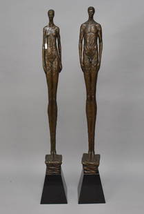
Sold2023Tom Corbin (American, b. 1954) Pair of 5ft. Tall Bronzes- Male and Female Signed and numbered atTom Corbin (American, b. 1954) Pair of 5ft. Tall Bronzes- Male and Female Signed and numbered at base ‘Tom Corbin 37/60 and 48/60. 62H x 7W x 6 ½D inchesSee Sold Price
2 days LeftTrillium Antique Prints & Rare BooksPrevost - Map of China, Korea, Japan, Phlippines and Surrounding Islands$50
May 30NY Elizabeth M. HANSIZ'S 1727 GERMANIA SACRA BLINDSTAMPED PIGSKIN ANTIQUE FOLIO WITH MAP$50(1 bid)
278 Lots AwayHermann Historica GmbHA large iron Celtic Latène sword, 1st century B.C. to 1st century A.D.See Sold Price
5 days LeftJasper521899. North West Passage, after Sir John Everett Millais - Antique illustration$30(1 bid)
2 days LeftTrillium Antique Prints & Rare BooksPrevost - Pair of Engravings of Chinese Boats or Junks$50
2 days LeftTrillium Antique Prints & Rare BooksPrevost - Pair of Engravings of Indian Coast and Ocean$50
May 25Auction WallstreetFlorida Highwaymen Al Black (b. 1947) Oil on Board painting. Without frame: 16.8"x23"$500(1 bid)