Sold2018Bellin: Antique Map of South Pole & Southern HemisphereTitle/Content of Map: South Pole & Southern Hemisphere Date Printed: 1740-70's Cartographer: J.N. Bellin & J.F. La Harpe Material/Medium: Paper Size: 22 1/4" x 22 1/4" Copperplate engraved. From the 'See Sold Price
Sold2017SDUK: Antique Celestial Star Map, South Pole, 1847Title/Content of Map: '[STARS, VI., South Pole.]' ASTRONOMY CELESTIAL. Star map. Star chart, VI. Date Printed: The alignment of the constellations is shown as at 1830; this date is printed on the map.See Sold Price
Sold2021Fullarton (Pub) 1856 Lot of 4 Antique British MapsIncl Ports and Harbours on the South East Coast of England, Ditto North West Scotland, Ditto South Coast England, and Plymouth Sound. Steel Engraved Map Published 1856-58, by A. Fullarton, London forSee Sold Price
Sold2024Kohler & Weigel - Map of the World with North and South Pole viewsThis originally hand-colored engraving is from Johnn David Kohler's Schul- und Reisen-Atlas aller zu Erlernung der alten, mittlern und neuen Geographie dienlichen Universal- und Particular-Charten...See Sold Price
Sold2017William Darton, (10) antique mapsWilliam Darton, (10) antique maps, William Darton (British, 19th c.), "The Western Hemisphere or New World", "South America", etc., 12.75"h x 10.5"w (sheet), unframed Provenance: Property from a majorSee Sold Price
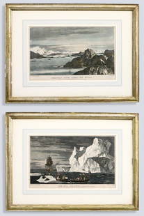
Sold20232 After Hodges Seascape EngravingsAfter William Hodges, British, 1744-1797. Two 18th century engraved seascapes on paper with hand-coloring from "A Voyage Towards the South Pole and Round the World..." by Captain James Cook. Titled "CSee Sold Price
20241897 HISTORICAL GEOGRAPHY of BRITISH COLONIES - AFRICA w/ MAPS V.4 antiqueHISTORICAL GEOGRAPHY of BRITISH COLONIES by C.P.LUCAS Vol. IV SOUTH and EAST AFRICA Part I: Historical Part II: Geographical Illustrated w/ maps Size 6 by 9.5" Very good condition, minor wear Text inSee Sold Price
Sold2023Nat. Encyclo. 1890's Mixed Lot of 32 Antique MapsIncl Sweden/Norway, Eastern USA, British Isles Geological, North America X 2, South America, Russia in Europe, Scotland, Britannia Antiqua, Suez Canal, China Proper, England and Wale, World HemisphereSee Sold Price
Sold2018Antique map, south America, Peruvia id est, Novi OrbisAntique map, south America, Peruvia id est, Novi Orbis pars Meridionalis a Praestantissima eius in Occidentem Regione sic Appellata. 1598, engraved in Cologne by Johann Bussemacher, framed, map size iSee Sold Price
Sold2018Antique map, south America, 1598, Johann BussemacherAntique map, south America, Peruvia id est, Novi Orbis pars Meridionalis a Praestantissima eius in Occidentem Regione sic Appellata. 1598, engraved in Cologne by Johann Bussemacher, framed, map size iSee Sold Price
Sold2018Johannes Kip After L. Knyff Antique British MapJohannes Kip After Leonard Knyff (1650-1722) antique map. Measures 13.75" x 18.75" (plate size) and 18" x 22 7/8" (sheet size). Vg/Vg+ condition. Unframed, loose and not mounted or glued down. We shipSee Sold Price
Sold2024Antique Map - South America - D.Veremondo Rossi - Brazil - Argentina - PeruThis wonderful engraving " Carta rappresentante l'America Meridionale" (Map representing South America.) originates from "ll Gazzettiere americano contenente un distinto ragguaglio di tutte le paSee Sold Price
Sold2024Antique Map - South America - Chart of Strait of Magellan - Patagonia - ChileThis large, original copper engraved, antique map, a chart of the Straits of Magellan, South America and the Patagonian & South Chilean shoreline was engraved by Robert Benard and published in theSee Sold Price
Sold20222 ANTIQUE MAPS SOUTH AMERICA1- 1830 Huntington Map South America Brazil Bolivia Peru Argentina Colombia Chile 11"x8 3/4". 2- Carte de la Partie Meridionale du Bresil c. 1780. 15"x9 3/4".See Sold Price
Sold2023Brookes & Baker 1797 Antique Map. South AmericaCopper Engraved Map Published 1797, London for "The General Gazetteer; Or, Compendious Geographical Dictionary" by Richard Brookes. Engraved by B. Baker. Original outline hand color. Folds as issued.See Sold Price
Sold2023Sherratt, Russell & Barclay 1821 Antique Map. South Shetland, Antarctic. Rare"Sketch of New South Shetland" Taken in Jan.y & Feb.y 1821. By R. Sherratt. Copper Engraved Map Published C1825., by Fisher & Son, "A Complete Atlas of the World" by John Russell et al. The companionSee Sold Price
Sold2019Barclay, James 1809 Antique Map. South AmericaOutline Hand Coloured Copper Engraved Map Published 1809, Leeds for "Barclay's Complete and Universal Dictionary of the English Language..." by the Rev. James Barclay. Paper Size: 10 x 8 inch (26 x 20See Sold Price
Sold2021Barlow 1807 Antique Map. South AmericaCopper Engraved Map Published 1807 by Brightly & Kinnersley, Bungay, England for "A General View of the World, Geographical, Historical and Philosophical" by The Rev. E. Blomfield. Engraved by Barlow.See Sold Price
Sold2021Findlay, Alex C1835 Antique Map. South AmericaSteel Engraved Map Published C1835 by Thomas Kelly, London for "A New and Universal English Dictionary" by the Rev. James Barclay. Maps Drawn & Engraved by Alexander Findlay. Paper Size: 10.5 x 8 inchSee Sold Price
Sold2022Butler, Samuel 1842 Antique Map. South AmericaSteel Engraved Map Published 1842, London for "An Atlas of Modern Geography" by Samuel Butler. Drawn & Engraved by Sidney Hall. Centre fold as published. Original outline hand colour. Paper Size: 10.5See Sold Price
Sold2022Kelly, Christopher 1836 Antique Map. South AmericaCopper Engraved Map Published 1836, London for "A New and Complete System of Universal Geography" by Christopher Kelly. Maps Engraved by Findlay, Wallis and others. Paper Size: 10.5 x 8 inch (27 x 20cSee Sold Price
Sold2024Walker, John C1805 Antique Map. South AmericaCopper Engraved Map Published C1805, London for "The Universal Gazetteer: Being a Concise Description" [Walker's Geography] by John Walker. Folds as issued. Paper Size: 10 x 8 inch (25 x 20cm) Some crSee Sold Price
Sold2024Russell, J. 1804 Antique Map. South AmericaCopper Engraved Map with outline hand color Published 1804 by W. Peacock, London for "A Compendious Geographical Dictionary" Drawn and Engraved by J. Russell. Folds as issued. Paper Size: 6.5 x 5 inchSee Sold Price
Sold2023Brookes, Richard 1791 Antique Map. South AmericaCopper Engraved Map Published 1791, London for "The General Gazetteer; Or, Compendious Geographical Dictionary" by Richard Brookes. Folds as issued. Paper Size: 10 x 8 inch (26 x 21cm)See Sold Price
Jun 12Jasper52A plan of the operations of the King's army… in New York… FADEN/STEDMAN 1794 map$6,500
14 hrs LeftJasper52Colonial Southern Africa. British Portuguese German. Madagascar. TIMES 1900 map$15
14 hrs LeftJasper52Africa. Congo Free Trade Area. British South Africa Company. STANFORD 1896 map$180
14 hrs LeftJasper52Colonial Southern Africa. British Portuguese German. Madagascar. TIMES 1895 map$20
Jun 12Jasper52A Topographical Map of the northn. part of New York Island… FADEN/STEDMAN 1794$3,200
14 hrs LeftJasper52Southern Africa Cape of Good Hope-Madagascar ADMIRALTY sea chart 1935 (1955) map$60
14 hrs LeftJasper52South Namibia coast. Walvis Bay-Orange River ADMIRALTY sea chart 1881 (1954) map$85
Jun 12Jasper52Rhodesia… British South Africa Company. Game reserves. Zimbabwe Zambia 1910 map$340
2 days LeftFreeman's | HindmanCOOK, James, Captain. -- [SECOND VOYAGE]. A Voyage towards the South Pole, and Round the World...$1,500


![SDUK: Antique Celestial Star Map, South Pole, 1847: Title/Content of Map: '[STARS, VI., South Pole.]' ASTRONOMY CELESTIAL. Star map. Star chart, VI. Date Printed: The alignment of the constellations is shown as at 1830; this date is printed on the map.](https://p1.liveauctioneers.com/5584/106754/54692074_1_x.jpg?height=310&quality=70&version=1500663236)


![Walker, John C1805 Antique Map. South America: Copper Engraved Map Published C1805, London for "The Universal Gazetteer: Being a Concise Description" [Walker's Geography] by John Walker. Folds as issued. Paper Size: 10 x 8 inch (25 x 20cm) Some cr](https://p1.liveauctioneers.com/3952/316007/169443235_1_x.jpg?height=310&quality=70&version=1705170023)


![COOK, James, Captain. -- [SECOND VOYAGE]. A Voyage towards the South Pole, and Round the World... (1 of 2)](https://p1.liveauctioneers.com/197/329395/177650491_1_x.jpg?height=282&quality=70&version=1715364962)


