Sold20231755 Fry Jefferson Map, French Edition First State"Carte de la Virginie et du Maryland dressee sur la grande carte angloise de Mrs. Josue Fry et Pierre Jefferson", hand colored first state of Robert de Vaugondy's French edition of the Fry Jefferson mSee Sold Price
Sold2017Amedee Rosier " The Grand Canal" Oil on PanelAmedee Rosier French 1831 - 1898 Venice, The Grand Canal Signed Lower Left. Label Verso " Montgomery Gallery" San Francisco, California. Dimensions: Art: 11" H x 16"See Sold Price
Sold2016GUILLAUME DELISLE (FRENCH 1675-1726), DOUBLE-PAGEGUILLAUME DELISLE (FRENCH 1675-1726), DOUBLE-PAGE ENGRAVED MAP, "CARTE DE LA LOUISIANE ET DU COURS DU MISSISSIPI", PARIS 1718, SECOND STATE. SIGHT 20 X 26"; FRAMED 26 3/4 X 32 3/4"See Sold Price
Sold2023RARE BUCHOLTZ-LUDWIG ANTEBELLUM POCKET MAP OF VIRGINIARARE BUCHOLTZ-LUDWIG ANTEBELLUM POCKET MAP OF VIRGINIA, hand-colored lithograph, Map of the State of Virginia Containing the Counties, Principal Towns, Railroads, Rivers, Canals & All Other Internal ISee Sold Price
Sold2020Ludwig Bemelmans, Fox Hunt Scene W/P(American/French 1898-1962), likely created for "Welcome Home," Harper & Brothers, 1960, signed lower right. Framed, not examined out of frame. Frame size: 28 1/2" high, 22" wide. Provenance: PropertySee Sold Price
Sold2023Jean Issy de Botton Floral Still Life O/C PaintingA Jean Issy de Botton (French, 1898-1978) oil on canvas still life depicting a floral and fruit arrangement on table. Signed lower left. Provenance: purchased from an estate in Orange, NJ, from the coSee Sold Price
Sold2022Adelaide Cole Chase American, 1868-1944 Portrait of Mrs. Hollis French, circa 1898Adelaide Cole Chase American, 1868-1944 Portrait of Mrs. Hollis French, circa 1898 Signed Adelaide Chase (ul); inscribed Mrs. Hollis French / 24 W .... St on the stretcher bar Oil on canvas 47 1/2 x 2See Sold Price
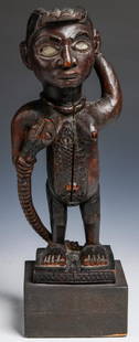
Sold2018Kongo "N'kisi" Magic Fetish, Congo, 19th/early 20th c.Kongo "N'kisi" Magic Fetish, Democratic Republic of Congo, Africa. Carved wooden female effigy shown with snake to breast, raised scarrification, inset glass eyes (female and snake). Well handled patiSee Sold Price
Sold2022Eugene Boudin (French, 1824-1898) Oil PaintingDESCRIPTION: Artist: Eugene Boudin, French (1824 - 1898), Year: circa 1894, Medium: Oil on board, signed. Depicting a dock setting with sailboats. ORIGIN: France DIMENSIONS: painting Size: 12" x 16" |See Sold Price
Sold2020Gastaldi Map of Africa*** START PRICE IS THE RESERVE *** [Africa]. GASTALDI, Giacomo (1500-1566) & FORLANI, Paolo (fl. 1560-1571). La Descrittione dell'Africa. Engraved Map. Venice: Paolo Forlani, 1562. 19 x 25 1/4 inchesSee Sold Price
Sold2022Stanislas Lépine (French, 1835-1892) Le Canal de la ViletteStanislas Lépine (French, 1835-1892) Le Canal de la Vilette signed 'S.Lepine' (lower left), inscribed with title (on remnants of an old label attached to the reverse) oil on canvas 24 x 33cm (9 7See Sold Price
Sold2015De Bry (Theodore) - Descriptio Hydrographicathe 2-sheet map of Africa and Asia, from the east coast of Brazil to Japan, charting the first Dutch voyage to the East Indies by Houtman, large titlecartouche upper centre of right sheet, ships, compSee Sold Price
Sold2022KELLY MILLER BROS. CIRCUS POSTERONE SHEET, WITH DATE TAIL, C.1960. GIANT JUNGLE BEAST FROM THE RIVER NILE IN AFRICA. UNMOUNTED, VERY GOOD. IMAGE 28"X48"See Sold Price
Sold2023Peter Max - Delta - Acrylic on CanvasPeter Max (1937 - ) United States of America. Delta. Acrylic on Canvas. H 43 x W 37 in. The artwork listed is an Original Mixed Media Peter Max Painting titled Delta. Max's art has been exhibited in mSee Sold Price
Sold2018Spanish American War Bond 1898American, 1898, $20 Spanish-American War 3% coupon bond, titled "Three Percent Loan of 1898", "United States of America", "1898-1918", serial number "20982", 16 rows of unclipped coupons, 22-1/2 xSee Sold Price
Sold20241831 Woodbridge Map of South America and Africa -- Comparative, Geographical & Statistical Map ofTitle: 1831 Woodbridge Map of South America and Africa -- Comparative, Geographical & Statistical Map of South America & Africa Cartographer: W. Woodbridge Year / Place: 1831, Hartford Map Dimension (See Sold Price
Sold2022A Songye Wood Male Mask (Kifwebe) Height 25 1/16 inches (63.8 cm).A Songye Wood Male Mask (Kifwebe) Central Africa, Democratic Republic of Congo Height 25 1/16 inches (63.8 cm). Property from Dayton Art Institute, Dayton, Ohio Provenance: Ms. Dianne Komminsk, giftedSee Sold Price
Sold2022(REPUBLIC OF TEXAS.) James Hamilton Young. A New Map of Texas, with the Contiguous American &(REPUBLIC OF TEXAS.) James Hamilton Young. A New Map of Texas, with the Contiguous American & Mexican States. Hand-colored engraved map of Texas with inset text panels relating information on its riveSee Sold Price
Sold2022(CIVIL WAR.) John Bachmann. Panorama of the Seat of War.(CIVIL WAR.) John Bachmann. Panorama of the Seat of War. Portfolio of 6 double-page chromolithographed panoramic perspective maps of Confederate states. Folio, 23½x17 inches, contemporary half moSee Sold Price
Sold2016A Map of the United States & MexicoHenry Tanner (1786-1858). New York: Tanner, 1850. Hand-colored Pocket Map. 23 x 29 inches visible, 38 x 39 1/2 inches framed.See Sold Price
Sold2024Ohio copy of Mathew Carey’s 1796 GENERAL ATLASCarey, Mathew (publisher). CAREY’S GENERAL ATLAS. Philadelphia: Printed by Mathew Carey, May 1, 1796. FOLIO (14.75 x 9.5 inches), COMPLETE AS PUBLISHED (including a Rare Map of The United States bySee Sold Price
Sold2018Young New Map of TexasA New Map of Texas with the contiguous American and Mexican States. James Hamilton Young. Engraved map with original hand color. Philadelphia: S. Augustus Mitchell, 1839. 13 x 15 1/2 inches visible, 1See Sold Price
Sold2024Early United States and large Mexico, 1808 by J. B. PierreTitle: Early United States and large Mexico, 1808 by J. B. Pierre Date/Period: c1808 Materials: Hand colored, Copperplate engraved Size: 12 3/4 x 8 3/4” Map of the early United States and a largSee Sold Price
Sold2019Circle of Hubert Robert, (French, 1733-1808)Circle of Hubert Robert (French, 1733-1808) "Architectural Capriccio by a Canal" oil on linen unsigned, remnant of old label on stretcher. Framed. 29" x 37", framed 38-1/2" x 46-1/2" Provenance: BlounSee Sold Price
Featured2 mins LeftJasper52CENTRAL AFRICA. French Congo German east British Angola Tanzania. BACON 1893 map$15
2 mins LeftJasper52CENTRAL AFRICA. Tanzania, Kenya, Angola, Zambia, Congo, Mozambique 1903 map$15(1 bid)
Jun 13Swann Auction Galleries(AFRICA.) Gerard Mercator; and Jodocus Hondius. Two double-page engraved regional maps of the$600
2 mins LeftJasper52COLONIAL CENTRAL AFRICA. Congo German East Africa Rhodesia. BARTHOLOMEW 1898 map$40
Featured2 mins LeftJasper52Central Africa. Congo Free State Rhodesia German East Africa. STANFORD 1896 map$280
2 mins LeftJasper52Central Africa. Congo Free State Rhodesia German East Africa. STANFORD 1904 map$220
2 mins LeftJasper52Central Africa. Congo Free State Rhodesia German East Africa. STANFORD 1894 map$280
2 mins LeftJasper52Colonial Central Africa. Belgian Congo. French Equatorial Africa. TIMES 1922 map$15
2 mins LeftJasper52NILE VALLEY. Sudan Tanzania Ethiopia Uganda Lake Victoria. Britannica. 1898 map$15
2 mins LeftJasper52FRENCH SUDAN (Now Mali). Soudan Français. Bamako city plan de la ville 1931 map$25
2 mins LeftJasper52FRENCH SUDAN (Now Mali). Soudan Français. Bamako city plan de la ville 1938 map$25
2 mins LeftJasper52FRENCH SUDAN (Now Mali). Soudan Français. Bamako city plan de la ville 1929 map$25
2 mins LeftJasper52Le Canal de Mosambique, l'Isle de Madagascar… Mozambique. Africa. BONNE 1788 map$15
2 mins LeftJasper52Le Canal de Mosambique, l'Isle de Madagascar… Mozambique. Africa. BONNE 1790 map$20
2 mins LeftJasper52L'Afrique Françoise ou du Senegal'. French West Africa. DE L’ISLE 1727 map$100
2 mins LeftJasper52CENTRAL AFRICA. International African Association (Congo) Gabon Angola 1889 map$45
Featured2 mins LeftJasper52COLONIES FRANÇAISES en AFRIQUE. Africa Sénégal Madagascar. LEVASSEUR c1850 map$65


![Gastaldi Map of Africa: *** START PRICE IS THE RESERVE *** [Africa]. GASTALDI, Giacomo (1500-1566) & FORLANI, Paolo (fl. 1560-1571). La Descrittione dell'Africa. Engraved Map. Venice: Paolo Forlani, 1562. 19 x 25 1/4 inches](https://p1.liveauctioneers.com/1968/163248/82424552_1_x.jpg?height=310&quality=70&version=1583340284)


